Donald · Central Belt
Blairdenon Hill
Blairdenon Hill (631m) is the western terminus of the Ochil watershed, a broad grassy dome rising above Sherrifmuir and the Allan Water. A vegetated rock marks the highest point of an otherwise featureless top, and the trig is set further along the ridge. The hill is known to local walkers as the wettest of the Ochil Donalds — its peaty plateau drains slowly toward both the Forth and the Allan.
Quick facts
- Height
- 631.9m/ 2073ft
- Prominence
- 95 m
- Distance
- 12 km
- Ascent
- 473 m
- Time
- 3–5 hrs
- Grid ref
- NN865018
- Parking
- NN881014
- Nearest city
- Stirling· 11km
- Dogs
- Dogs on lead required near livestockDog-friendly guide ↗
Height and prominence cross-checked against the Database of British and Irish Hills (CC BY).
No GPX track yet
Walked this route? Share your track to help other walkers.
Standard route
grass slopes 65% · heather patches 25% · summit area 10%
The most direct line starts from the Sheriffmuir road at NT828022 and follows estate tracks west to the open hill before climbing peaty slopes to the summit — 12km with 473m of ascent. The line crosses heather and rough pasture before the broad plateau, where quad tracks fade out. Many walkers continue east along the watershed toward Ben Cleuch in a longer Ochil round.
Terrain
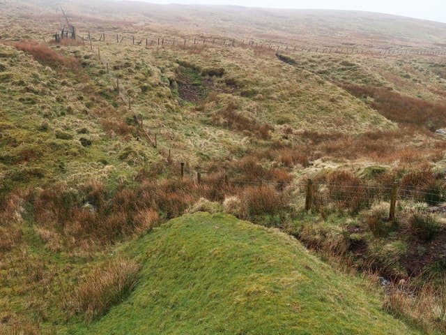
The plateau is famously boggy — the andesitic bedrock holds water and creates wide stretches of soft peat and sphagnum bog. The Sheriffmuir approach uses good tracks for the lower section but the summit dome is path-free. Fence lines run intermittently across the top and provide some navigational structure in mist.
In winter
Modest in stature but high enough to catch full Atlantic weather, Blairdenon's saturated peat becomes treacherously slick when frozen and topped with thin snow. The plateau ices over readily and the gentle gradient hides serious cornicing on the steep northern coires above Glen Tye. Visibility drops fast on this exposed western edge of the Ochils.
Best time of year
Getting there
- Glasgow1h 5m
- Edinburgh1h 9m
OS maps: OS Landranger 58
Mobile signal: Signal is good; EE and Vodafone dependable. Clear views across central Scotland.
Current conditions
Daylight Today
- Sunrise
- 04:52
- Sunset
- 21:51
- Civil dawn
- 03:56
- Civil dusk
- 22:47
NOAA Solar Calculator · 17 July 2026
Around Blairdenon Hill on the SCOT network
Getting there, basing yourself, and what to do off the hill.
Getting there: Dunblane station
Stirling-area; Sheriffmuir; gateway north
9km from the hill
tripscot.co.uk
On TripSCOTBase yourself in Callander
Trossachs gateway — Ben Ledi, Stuc a Chroin, Rob Roy Way
24km from the hill
tripscot.co.uk
On TasteSCOTAfter the hill: Tullibardine
Blackford — central Highland distillery on the A9 between Stirling and Perth
7km from the hill
tastescot.co.uk
Blairdenon Hill — common questions
- What difficulty is Blairdenon Hill?
- On the OutdoorSCOT scale, Blairdenon Hill comes in at 3/5 — moderately challenging. Expect roughly 12km and 473m of ascent on the usual route — 3-5 hours for most parties. Ground conditions: The plateau is famously boggy — the andesitic bedrock holds water and creates wide stretches of soft peat and sphagnum bog.
- How much drop does Blairdenon Hill have?
- The drop is 95m: measured from the summit of Blairdenon Hill down to the saddle joining it to higher terrain.
- Where's the parking for Blairdenon Hill?
- Park at NN881014. Double-check the grid reference on an OS map first; informal laybys here fill early in high season.
- What's the best month to climb Blairdenon Hill?
- Aim for March, April, May, June, July, August, September, October, November on Blairdenon Hill. In the remaining months treat it as a winter hill — full kit, solid navigation, and a look at the relevant SAIS avalanche forecast before you go.
- Can dogs go up Blairdenon Hill?
- Dogs are fine on a lead. The route passes livestock or ground-nesting bird habitat, so keep them close throughout.
- Will I get phone signal on Blairdenon Hill?
- Signal is good; EE and Vodafone dependable. Clear views across central Scotland.
- Is Blairdenon Hill safe in winter?
- Modest in stature but high enough to catch full Atlantic weather, Blairdenon's saturated peat becomes treacherously slick when frozen and topped with thin snow. The plateau ices over readily and the gentle gradient hides serious cornicing on the steep northern coires above Glen Tye. Visibility drops fast on this exposed western edge of the Ochils.
Get the OutdoorSCOT weekly
One email a week — new route, hill and bothy guides, seasonal conditions and the odd hard-won lesson. No spam, unsubscribe in one click.