Graham · Central Belt
Ben Cleuch
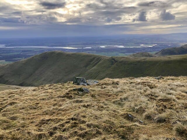
Ben Cleuch (721m) is the highest of the Ochil Hills, rising from the NN90 escarpment behind Tillicoultry and Dollar. A trig pillar set in a sunken windshelter crowns a tussocky plateau with views south across the Forth meanders to Edinburgh and the Pentlands, and north to the Highland line at Ben Vorlich and Schiehallion. As county top of Clackmannanshire it draws Hillfoots locals on weekday evenings, yet wind funnelling up the Mill Glen scarp still surprises first-timers.
Quick facts
- Height
- 721m/ 2365ft
- Prominence
- 595 m
- Distance
- 13 km
- Ascent
- 591 m
- Time
- 3–6 hrs
- Grid ref
- NN902006
- Parking
- NN917089
- Nearest city
- Stirling· 13km
- Dogs
- Dogs on lead required near livestockDog-friendly guide ↗
Height and prominence cross-checked against the Database of British and Irish Hills (CC BY).
No GPX track yet
Walked this route? Share your track to help other walkers.
Standard route
glen path 20% · open hillside 45% · grassy plateau 25% · summit area 10%
The classic ascent climbs the Mill Glen from Tillicoultry car park, threading the burn through hawthorn and rowan before breaking out below the Law. A clear path then climbs the steep grass shoulder of Ben Ever, drops to the Maddy Moss bealach and rises onto the Cleuch plateau. Total distance 13km with 591m of ascent; descent via the Daiglen burn or back over Andrew Gannel Hill to the same parking.
Terrain
Mill Glen path is rocky and slippery after rain, with handrails on the steeper steps. Above 400m the gradient eases to short Ochils turf grazed by sheep — fast going in dry weather but bog-saturated in spring. The summit windshelter offers the only respite on a plateau that catches every airflow from the Forth estuary.
In winter
Snow rarely lingers below 500m but the Cleuch tops collect easterly drift, with windslab forming on the lee of Andrew Gannel. SAIS does not cover the Ochils, so judgement is on the walker; verglas glazes the basalt steps in Mill Glen after thaw-refreeze cycles. December daylight is roughly eight hours at this latitude — manageable but plan around an early start.
Best time of year
Getting there
- Glasgow1h 7m
- Edinburgh1h 3m
OS maps: OS Landranger 58
Mobile signal: Good signal from Stirling/Alloa; 3 bars at the cairn
Current conditions
Daylight Today
- Sunrise
- 04:46
- Sunset
- 21:56
- Civil dawn
- 03:48
- Civil dusk
- 22:54
NOAA Solar Calculator · 13 July 2026
Around Ben Cleuch on the SCOT network
Getting there, basing yourself, and what to do off the hill.
Getting there: Dunblane station
Stirling-area; Sheriffmuir; gateway north
12km from the hill
tripscot.co.uk
On TripSCOTBase yourself in Callander
Trossachs gateway — Ben Ledi, Stuc a Chroin, Rob Roy Way
28km from the hill
tripscot.co.uk
On TasteSCOTAfter the hill: Tullibardine
Blackford — central Highland distillery on the A9 between Stirling and Perth
7km from the hill
tastescot.co.uk
Ben Cleuch — common questions
- How difficult is Ben Cleuch?
- Ben Cleuch carries a 3/5 (moderately challenging) grade on the OutdoorSCOT scale. Count on about 13km, 591m of ascent and a 3-6 hour day on the standard route. Ground conditions: Mill Glen path is rocky and slippery after rain, with handrails on the steeper steps.
- How much drop does Ben Cleuch have?
- The drop is 595m: measured from the summit of Ben Cleuch down to the saddle joining it to higher terrain.
- Where's the parking for Ben Cleuch?
- Park at NN917089. Double-check the grid reference on an OS map first; informal laybys here fill early in high season.
- What's the best month to climb Ben Cleuch?
- Aim for April, May, June, July, August, September, October on Ben Cleuch. In the remaining months treat it as a winter hill — full kit, solid navigation, and a look at the relevant SAIS avalanche forecast before you go.
- Can dogs go up Ben Cleuch?
- Dogs are fine on a lead. The route passes livestock or ground-nesting bird habitat, so keep them close throughout.
- Will I get phone signal on Ben Cleuch?
- Good signal from Stirling/Alloa; 3 bars at the cairn
- Is Ben Cleuch safe in winter?
- Snow rarely lingers below 500m but the Cleuch tops collect easterly drift, with windslab forming on the lee of Andrew Gannel. SAIS does not cover the Ochils, so judgement is on the walker; verglas glazes the basalt steps in Mill Glen after thaw-refreeze cycles. December daylight is roughly eight hours at this latitude — manageable but plan around an early start.
Get the OutdoorSCOT weekly
One email a week — new route, hill and bothy guides, seasonal conditions and the odd hard-won lesson. No spam, unsubscribe in one click.