Donald · Central Belt
Innerdownie
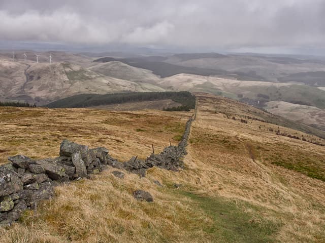
Innerdownie (610m) is the easternmost Donald in the Ochil chain, a rolling heather dome above the Devon gorge near Rumbling Bridge. An embedded rock beside an old march wall marks the summit. The hill is the natural eastern continuation of the great Ochil watershed — beyond it the ground falls away to the Devon and the Cleish Hills appear across the valley. It is most often paired with Whitewisp Hill in a there-and-back round.
Quick facts
- Height
- 610m/ 2001ft
- Prominence
- 52 m
- Distance
- 12 km
- Ascent
- 458 m
- Time
- 3–5 hrs
- Grid ref
- NN966031
- Parking
- NN980047
- Nearest city
- Stirling· 20km
- Dogs
- Dogs on lead required near livestockDog-friendly guide ↗
Height and prominence cross-checked against the Database of British and Irish Hills (CC BY).
No GPX track yet
Walked this route? Share your track to help other walkers.
Standard route
grass slopes 60% · heather patches 30% · summit area 10%
From the Glen Quey car park near Glendevon at NN980047 a clear path climbs through forestry plantations and onto open hill to gain Whitewisp Hill, then follows the watershed wall east to Innerdownie's summit — 12km with 458m of ascent. The track is forestry-graded for the lower section and the upper ridge is short heather with a march wall as handrail. The summit rock requires a small detour from the wall to identify.
Terrain
Mixed terrain — forestry tracks giving way to open hill of heather and short grass on andesitic bedrock. The march wall along the watershed is well-built and continuous, and serves as the principal navigational feature. Glen Quey reservoir below provides a useful visual anchor on the descent and the Devon gorge is a striking lower feature.
In winter
The eastern Ochils catch full Atlantic weather and Innerdownie's exposed top sees significant snow accumulation despite its modest altitude. The forestry sections shelter the lower approach but the open ridge ices hard along the march wall. Verglas on the embedded summit rock makes it slick — touch the wall instead. SAIS no coverage; rely on local conditions reports.
Best time of year
Getting there
- Glasgow1h 16m
- Edinburgh1h 59m
OS maps: OS Landranger 58
Mobile signal: Coverage is solid; EE and Vodafone reliable. Fine Ochils viewpoint above Rumbling Bridge.
Current conditions
Daylight Today
- Sunrise
- 04:45
- Sunset
- 21:56
- Civil dawn
- 03:47
- Civil dusk
- 22:54
NOAA Solar Calculator · 13 July 2026
Around Innerdownie on the SCOT network
Getting there, basing yourself, and what to do off the hill.
Getting there: Gleneagles station
Glen Devon; Ochil ridges; Auchterarder; PGA Centenary course access
10km from the hill
tripscot.co.uk
On TripSCOTBase yourself in Callander
Trossachs gateway — Ben Ledi, Stuc a Chroin, Rob Roy Way
34km from the hill
tripscot.co.uk
On TasteSCOTAfter the hill: Tullibardine
Blackford — central Highland distillery on the A9 between Stirling and Perth
8km from the hill
tastescot.co.uk
Innerdownie — common questions
- How difficult is Innerdownie?
- Innerdownie carries a 3/5 (moderately challenging) grade on the OutdoorSCOT scale. Count on about 12km, 458m of ascent and a 3-5 hour day on the standard route. Terrain: Mixed terrain — forestry tracks giving way to open hill of heather and short grass on andesitic bedrock.
- How prominent is Innerdownie?
- Innerdownie has 52m of topographic prominence — the height of its summit above the highest col connecting it to higher ground.
- Where should I park to climb Innerdownie?
- Standard parking is at NN980047. Check the parking grid reference on an OS map before travel; informal laybys can fill on summer weekends.
- When should I climb Innerdownie?
- The standard good-weather months for Innerdownie are March, April, May, June, July, August, September, October, November. Outside those months, expect winter conditions on the high ground — full mountain kit, navigation skills, and a check of the SAIS avalanche forecast for the relevant region.
- Can I bring my dog up Innerdownie?
- On a lead only — the route crosses ground with livestock or nesting-bird interest.
- What's mobile reception like on Innerdownie?
- Coverage is solid; EE and Vodafone reliable. Fine Ochils viewpoint above Rumbling Bridge.
- Is Innerdownie safe in winter?
- The eastern Ochils catch full Atlantic weather and Innerdownie's exposed top sees significant snow accumulation despite its modest altitude. The forestry sections shelter the lower approach but the open ridge ices hard along the march wall. Verglas on the embedded summit rock makes it slick — touch the wall instead. SAIS no coverage; rely on local conditions reports.
Get the OutdoorSCOT weekly
One email a week — new route, hill and bothy guides, seasonal conditions and the odd hard-won lesson. No spam, unsubscribe in one click.