Donald · Central Belt
Ben Cleuch
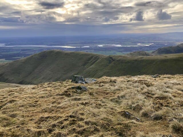
Ben Cleuch is the highest of the Ochils — Scotland's great volcanic wall between the Forth and Strathallan. A circular windshelter wraps the trig pillar, and on a fair day the view stretches from the Pentlands across the Forth to the Trossachs and the southern edge of the Highlands.
Quick facts
- Height
- 721m/ 2365ft
- Prominence
- 595 m
- Distance
- 13 km
- Ascent
- 591 m
- Time
- 3–6 hrs
- Grid ref
- NN902006
- Parking
- NN917089
- Nearest city
- Stirling· 13km
- Dogs
- Dogs on lead required near livestockDog-friendly guide ↗
Height and prominence cross-checked against the Database of British and Irish Hills (CC BY).
No GPX track yet
Walked this route? Share your track to help other walkers.
Standard route
grass slopes 60% · heather moorland 30% · rocky outcrops 10%
The classic ascent from Tillicoultry climbs the famous Daiglen and Ben Cleuch tourist path past the Mill Glen, then crosses the heather of the Law before the final pull. Many parties extend it over Andrew Gannel Hill to make a half-day round.
Terrain
Tillicoultry path is well-maintained pitched stone all the way to the Law. Above that, springy turf and short heath cover steep slopes. The escarpment edges are abrupt — keep children well clear of the lip.
In winter
Pitched stone steps glaze with verglas after a freeze-thaw cycle and have caused many ankle injuries over the years. The summit funnels easterly winds savagely; the windshelter is no joke and gets full use in February.
Best time of year
Getting there
- Glasgow1h 7m
- Edinburgh1h 3m
OS maps: OS Landranger 58
Mobile signal: Reliable up top; EE and Vodafone both fine. Clear views across central Scotland.
Current conditions
Daylight Today
- Sunrise
- 04:46
- Sunset
- 21:56
- Civil dawn
- 03:48
- Civil dusk
- 22:54
NOAA Solar Calculator · 13 July 2026
Pair with
Curated multi-hill combinations from Ben Cleuch.
Around Ben Cleuch on the SCOT network
Getting there, basing yourself, and what to do off the hill.
Getting there: Dunblane station
Stirling-area; Sheriffmuir; gateway north
12km from the hill
tripscot.co.uk
On TripSCOTBase yourself in Callander
Trossachs gateway — Ben Ledi, Stuc a Chroin, Rob Roy Way
28km from the hill
tripscot.co.uk
On TasteSCOTAfter the hill: Tullibardine
Blackford — central Highland distillery on the A9 between Stirling and Perth
7km from the hill
tastescot.co.uk
Ben Cleuch — common questions
- How difficult is Ben Cleuch?
- Ben Cleuch carries a 3/5 (moderately challenging) grade on the OutdoorSCOT scale. Count on about 13km, 591m of ascent and a 3-6 hour day on the standard route. Ground conditions: Tillicoultry path is well-maintained pitched stone all the way to the Law.
- How much drop does Ben Cleuch have?
- The drop is 595m: measured from the summit of Ben Cleuch down to the saddle joining it to higher terrain.
- Where's the parking for Ben Cleuch?
- Park at NN917089. Double-check the grid reference on an OS map first; informal laybys here fill early in high season.
- What's the best month to climb Ben Cleuch?
- Aim for April, May, June, July, August, September, October on Ben Cleuch. In the remaining months treat it as a winter hill — full kit, solid navigation, and a look at the relevant SAIS avalanche forecast before you go.
- Can dogs go up Ben Cleuch?
- Dogs are fine on a lead. The route passes livestock or ground-nesting bird habitat, so keep them close throughout.
- Will I get phone signal on Ben Cleuch?
- Reliable up top; EE and Vodafone both fine. Clear views across central Scotland.
- Is Ben Cleuch safe in winter?
- Pitched stone steps glaze with verglas after a freeze-thaw cycle and have caused many ankle injuries over the years. The summit funnels easterly winds savagely; the windshelter is no joke and gets full use in February.
Get the OutdoorSCOT weekly
One email a week — new route, hill and bothy guides, seasonal conditions and the odd hard-won lesson. No spam, unsubscribe in one click.