Corbett · Far North
Cranstackie
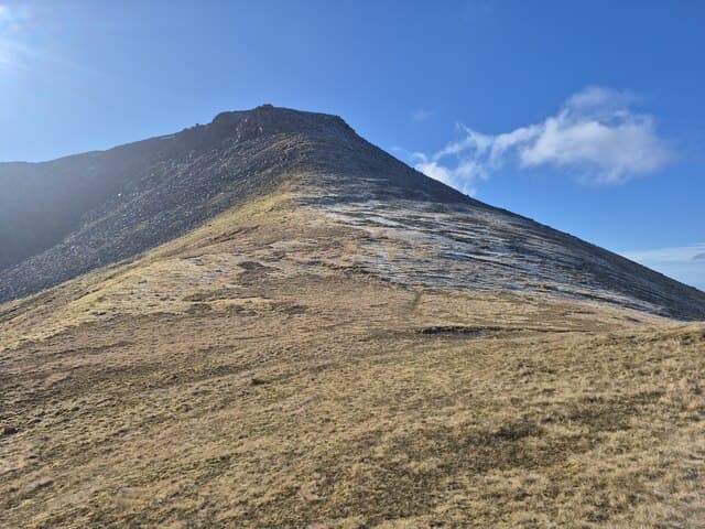
Cranstackie is the northern outlier of the Foinaven group — a quartzite ridge rising above the road from Rhiconich to Durness in the far north-west of Sutherland. The hill is overshadowed by its more famous neighbour but offers many of the same characteristics on a friendlier scale: pale quartzite blocks underfoot, a long summit ridge, and views to Cape Wrath that no other Corbett quite matches. Often climbed together with neighbouring Beinn Spionnaidh as a Sutherland double.
Quick facts
- Height
- 801m/ 2628ft
- Prominence
- 560 m
- Distance
- 13 km
- Ascent
- 850 m
- Time
- 4–6 hrs
- Grid ref
- NC350556
- Parking
- NC356588
- Nearest
- Ullapool
- Dogs
- Dogs on lead required near livestockDog-friendly guide ↗
Height and prominence cross-checked against the Database of British and Irish Hills (CC BY).
No GPX track yet
Walked this route? Share your track to help other walkers.
Standard route
moorland path 20% · quartzite slope 40% · rocky ridge 30% · summit rocks 10%
Start at the small parking area near Carbreck on the A838 (NC356588), a few kilometres south of Durness. Walk south across rough peat moorland for around 2km, then climb the broad north ridge of Cranstackie onto the quartzite. Follow the ridge south to the summit cairn. To include Beinn Spionnaidh, continue along the ridge — the bealach between them is broad and uncomplicated. Allow 5–6 hours for Cranstackie alone, 7–8 for the double.
Terrain
Wet peat and tussock on the approach — slow but short. Above 400m the terrain becomes quartzite blocks of the same family as Foinaven's, polished and slippery in the wet. The summit ridge is broad and uncomplicated; the descent line is straightforward if you stay on the broad north ridge.
In winter
Far-north winter conditions apply: short daylight (under 7 hours in late December), exposure to Atlantic and Arctic systems, and treacherous quartzite under verglas. The approach moorland freezes into a rink in cold spells. Magnificent on a clear cold day, miserable in marginal weather.
Best time of year
Getting there
- Glasgow6h 35m
- Edinburgh6h 41m
OS maps: OS Landranger 9
Mobile signal: The hill itself is blank; brief EE/Vodafone on the A838 between Rhiconich and Durness
Current conditions
Daylight Today
- Sunrise
- 04:33
- Sunset
- 22:17
- Civil dawn
- 03:24
- Civil dusk
- 23:26
NOAA Solar Calculator · 13 July 2026
Pair with
Curated multi-hill combinations from Cranstackie.
Around Cranstackie on the SCOT network
Getting there, basing yourself, and what to do off the hill.
Cranstackie — common questions
- How difficult is Cranstackie?
- Cranstackie carries a 3/5 (moderately challenging) grade on the OutdoorSCOT scale. Count on about 13km, 850m of ascent and a 4-6 hour day on the standard route. Underfoot: Wet peat and tussock on the approach — slow but short.
- What is Cranstackie's prominence?
- 560m of prominence. That's the vertical drop from the summit to the col that links Cranstackie to the next higher ground.
- Where do I park for Cranstackie?
- Most walkers start from NC356588 near Ullapool. Verify the grid reference on an OS map before you set off — space is tight on busy summer weekends.
- When is the best time to climb Cranstackie?
- May, June, July, August, September give the most reliable conditions on Cranstackie. Beyond that window the high ground turns wintry: carry full mountain kit, be confident navigating, and check the SAIS avalanche forecast for the area.
- Is Cranstackie dog-friendly?
- Yes, but dogs must be kept on a lead — there is livestock or ground-nesting bird interest on the route.
- Is there mobile signal on Cranstackie?
- The hill itself is blank; brief EE/Vodafone on the A838 between Rhiconich and Durness
- Is Cranstackie safe in winter?
- Far-north winter conditions apply: short daylight (under 7 hours in late December), exposure to Atlantic and Arctic systems, and treacherous quartzite under verglas. The approach moorland freezes into a rink in cold spells. Magnificent on a clear cold day, miserable in marginal weather.
Get the OutdoorSCOT weekly
One email a week — new route, hill and bothy guides, seasonal conditions and the odd hard-won lesson. No spam, unsubscribe in one click.