Corbett · Far North
Beinn Spionnaidh
Beinn Spionnaidh — 'the strength mountain' — is the northern arm of the Cranstackie horseshoe, the most northerly Corbett on mainland Scotland and a natural pairing with its neighbour. The 773m summit sits at the end of a quartzite ridge running roughly south to north above the Strath Dionard, with the dramatic cliffs of the Foinaven group visible to the south-west and the Pentland Firth to the north. The hill is rarely climbed alone — most parties do the two-Corbett round from the A838 — but on its own it makes a short and satisfying half-day from the road.
Quick facts
- Height
- 773m/ 2536ft
- Prominence
- 211 m
- Distance
- 10 km
- Ascent
- 720 m
- Time
- 2–5 hrs
- Grid ref
- NC361572
- Parking
- NC356588
- Nearest
- Ullapool
- Dogs
- Dogs on lead required near livestockDog-friendly guide ↗
Height and prominence cross-checked against the Database of British and Irish Hills (CC BY).
No GPX track yet
Walked this route? Share your track to help other walkers.
Standard route
moorland path 20% · quartzite slope 40% · rocky ridge 30% · summit area 10%
Starting point and approach mirror Cranstackie's: park at the small layby on the A838 near Carbreck (NC356588). Cross the rough moorland east of the road, then climb the broad south ridge of Beinn Spionnaidh directly. For the natural double, continue south over the bealach to Cranstackie. Beinn Spionnaidh alone takes 4–5 hours; the double takes 7–8.
Terrain
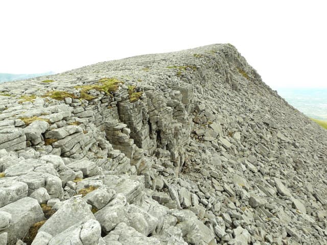
Wet moorland on the short approach, transitioning to quartzite blocks on the upper south ridge. The blocks here are smaller and less polished than on Foinaven proper — slightly easier underfoot in the wet but still demanding careful footwork. The top itself is a broad rocky plateau with the cairn protected by a low wind-shelter, useful in any northerly weather.
In winter
In winter Beinn Spionnaidh experiences the same far-north exposure as Cranstackie and Foinaven — short midwinter daylight, fierce wind off the Pentland Firth, and treacherous quartzite under ice. The shorter route compared to Foinaven makes it a more sensible choice for first-time winter visitors to the area. In clear cold conditions the views to Cape Wrath are among the finest in Britain.
Best time of year
Getting there
- Glasgow6h 37m
- Edinburgh6h 42m
OS maps: OS Landranger 9
Mobile signal: No signal on the hill; brief EE/Vodafone on the A838 between Rhiconich and Durness
Current conditions
Daylight Today
- Sunrise
- 04:39
- Sunset
- 22:12
- Civil dawn
- 03:34
- Civil dusk
- 23:17
NOAA Solar Calculator · 17 July 2026
Pair with
Curated multi-hill combinations from Beinn Spionnaidh.
Around Beinn Spionnaidh on the SCOT network
Getting there, basing yourself, and what to do off the hill.
Beinn Spionnaidh — common questions
- What difficulty is Beinn Spionnaidh?
- On the OutdoorSCOT scale, Beinn Spionnaidh comes in at 2/5 — moderate. Expect roughly 10km and 720m of ascent on the usual route — 2-5 hours for most parties. Ground conditions: Wet moorland on the short approach, transitioning to quartzite blocks on the upper south ridge.
- How much drop does Beinn Spionnaidh have?
- The drop is 211m: measured from the summit of Beinn Spionnaidh down to the saddle joining it to higher terrain.
- Where's the parking for Beinn Spionnaidh?
- Park at NC356588 near Ullapool. Double-check the grid reference on an OS map first; informal laybys here fill early in high season.
- What's the best month to climb Beinn Spionnaidh?
- Aim for May, June, July, August, September on Beinn Spionnaidh. In the remaining months treat it as a winter hill — full kit, solid navigation, and a look at the relevant SAIS avalanche forecast before you go.
- Can dogs go up Beinn Spionnaidh?
- Dogs are fine on a lead. The route passes livestock or ground-nesting bird habitat, so keep them close throughout.
- Will I get phone signal on Beinn Spionnaidh?
- No signal on the hill; brief EE/Vodafone on the A838 between Rhiconich and Durness
- Is Beinn Spionnaidh safe in winter?
- In winter Beinn Spionnaidh experiences the same far-north exposure as Cranstackie and Foinaven — short midwinter daylight, fierce wind off the Pentland Firth, and treacherous quartzite under ice. The shorter route compared to Foinaven makes it a more sensible choice for first-time winter visitors to the area. In clear cold conditions the views to Cape Wrath are among the finest in Britain.
Get the OutdoorSCOT weekly
One email a week — new route, hill and bothy guides, seasonal conditions and the odd hard-won lesson. No spam, unsubscribe in one click.