Corbett · Far North
Ben Loyal - An Caisteal
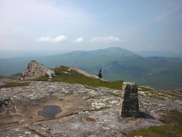
Ben Loyal — often called the Queen of Scottish mountains — rises in four granite turrets above the Kyle of Tongue at the northern edge of the country. An Caisteal at 764m is the highest of the tops and the official Corbett summit. The mountain stands almost on its own in the rolling Sutherland country between Tongue and Altnaharra, and the views from its summit ridge run from Foinaven and Ben Hope in the west to the Caithness flow country in the east. The walking is moderate; the setting is among the wildest in Britain.
Gaelic: “mountain, the, castle” · Pronunciation: ben loyal an kash-til
Quick facts
- Height
- 764.2m/ 2507ft
- Prominence
- 609 m
- Distance
- ~16 km
- Ascent
- ~850 m
- Time
- 4–7 hrs
- Grid ref
- NC578488
- Parking
- NC585533
- Nearest
- Ullapool
- Dogs
- Dogs on lead required near livestockDog-friendly guide ↗
Height and prominence cross-checked against the Database of British and Irish Hills (CC BY).
No GPX track yet
Walked this route? Share your track to help other walkers.
Standard route
farm track 15% · bog and heather 30% · rocky ridge 40% · summit scramble 15%
The standard ascent leaves the road south of Tongue near Ribigill Farm (NC585533). A rough track and path lead south across open moorland to the foot of the hill, then climb steeply onto the broad north ridge. Once on the granite, the route follows the ridge south over Sgor a' Bhatain to An Caisteal, the highest top. A short scramble onto the summit blocks adds character. Strong walkers continue south over Beinn Bheag and Carn an Tionail. Allow 6–7 hours.
Terrain
Wet moorland and rough heather on the approach — slow in any weather, sticky in rain. The granite ridge above is firmer underfoot with some short rocky steps. The summit of An Caisteal involves a brief easy scramble onto a tower of granite blocks; not technical but exposed.
In winter
Ben Loyal in winter is a serious far-north expedition. Midwinter daylight on this coast struggles past mid-afternoon, the approach from Ribigill freezes into a rink, and the granite ridge is fully exposed to Atlantic and Arctic winds. On a stable cold day with good visibility the mountain comes into its own — pale granite turrets above white moor — but in marginal weather the distance from help and the absence of phone signal change the calculation.
Kit for this: the winter Munro kit list · which boots take crampons
Best time of year
Getting there
- Glasgow5h 27m
- Edinburgh5h 26m
OS maps: OS Landranger 10
Mobile signal: Patchy on the lower approach; brief 4G on the summit looking north to Tongue and the Kyle
Current conditions
Daylight Today
- Sunrise
- 07:51
- Sunset
- 18:17
- Civil dawn
- 07:10
- Civil dusk
- 18:57
NOAA Solar Calculator · 14 October 2026
Pair with
Curated multi-hill combinations from Ben Loyal - An Caisteal.
Around Ben Loyal - An Caisteal on the SCOT network
Getting there, basing yourself, and what to do off the hill.
Ben Loyal - An Caisteal — common questions
- What difficulty is Ben Loyal - An Caisteal?
- On the OutdoorSCOT scale, Ben Loyal - An Caisteal comes in at 3/5 — moderately challenging. Expect roughly 16km and 850m of ascent on the usual route — 4-7 hours for most parties. Ground conditions: Wet moorland and rough heather on the approach — slow in any weather, sticky in rain.
- How much drop does Ben Loyal - An Caisteal have?
- The drop is 609m: measured from the summit of Ben Loyal - An Caisteal down to the saddle joining it to higher terrain.
- Where's the parking for Ben Loyal - An Caisteal?
- Park at NC585533 near Ullapool. Double-check the grid reference on an OS map first; informal laybys here fill early in high season.
- What's the best month to climb Ben Loyal - An Caisteal?
- Aim for May, June, July, August, September on Ben Loyal - An Caisteal. In the remaining months treat it as a winter hill — full kit, solid navigation, and a look at the relevant SAIS avalanche forecast before you go.
- Can dogs go up Ben Loyal - An Caisteal?
- Dogs are fine on a lead. The route passes livestock or ground-nesting bird habitat, so keep them close throughout.
- Will I get phone signal on Ben Loyal - An Caisteal?
- Patchy on the lower approach; brief 4G on the summit looking north to Tongue and the Kyle
- Is Ben Loyal - An Caisteal safe in winter?
- Ben Loyal in winter is a serious far-north expedition. Midwinter daylight on this coast struggles past mid-afternoon, the approach from Ribigill freezes into a rink, and the granite ridge is fully exposed to Atlantic and Arctic winds. On a stable cold day with good visibility the mountain comes into its own — pale granite turrets above white moor — but in marginal weather the distance from help and the absence of phone signal change the calculation.
Get the OutdoorSCOT weekly
One email a week — new route, hill and bothy guides, seasonal conditions and the odd hard-won lesson. No spam, unsubscribe in one click.