Munro · Cairngorms
Monadh Mor
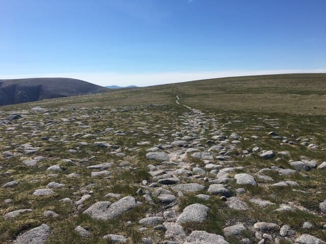
Monadh Mor is the 1113m Munro on the southern Cairngorm plateau, paired with Beinn Bhrotain across a broad bealach. The hill is one of the remotest summits in the range — its very name simply means "big mountain" and the position high above the head of Glen Geusachan gives a real sense of wilderness. The summit is a rock on a wide flat plateau with arctic-alpine vegetation; the view east toward Devil's Point and Cairn Toul across the head of the Glen Dee basin is among the great Cairngorm panoramas.
Gaelic: “big” · Pronunciation: monadh more
Quick facts
- Height
- 1113.4m/ 3653ft
- Prominence
- 139 m
- Distance
- 18 km
- Ascent
- 980 m
- Time
- 6–9 hrs
- Grid ref
- NN938942
- Parking
- NO062898
- Nearest city
- Inverness· 58km
- Dogs
- Dogs on lead required near livestockDog-friendly guide ↗
Height and prominence cross-checked against the Database of British and Irish Hills (CC BY).
No GPX track yet
Walked this route? Share your track to help other walkers.
Standard route
Estate track 40% · Open moorland 35% · Summit plateau 25%
Begin at Linn of Dee, follow Glen Lui through to White Bridge, then turn west up Glen Geusachan to gain the broad south ridge of Monadh Mor. Around 28km return with 980m of ascent — bike strongly recommended for the long approach track. Almost always combined with Beinn Bhrotain across the connecting bealach for a two-Munro southern Cairngorms day.
Terrain
The Glen Lui and White Bridge tracks are bike-friendly gravel. Off the track the climb into Glen Geusachan is wet bog and pathless heather. The summit plateau is broad granite gravel and arctic moss — featureless on a misty day. No exposure on the plateau, but the navigation challenge demands compass work.
In winter
A long and committing remote winter Munro. The plateau becomes a featureless white expanse under cloud cover. Cornicing along the south rim of Glen Geusachan. Phone signal is absent throughout — at least 15km from any road in any direction. SAIS Northern Cairngorms applies. Plan a bivvy or use Corrour bothy to break the day.
This hill is in the Northern Cairngorms SAIS forecast area. Check SAIS forecasts in winter (December–April).
Best time of year
Getting there
- Glasgow3h 50m
- Edinburgh3h 39m
OS maps: OS Landranger 36, OS Landranger 43
Mobile signal: No signal whatsoever on the remote southern Cairngorm plateau. Linn of Dee is the last place with any coverage. Download maps before leaving Braemar.
Current conditions
Daylight Today
- Sunrise
- 06:00
- Sunset
- 20:35
- Civil dawn
- 05:18
- Civil dusk
- 21:18
NOAA Solar Calculator · 24 August 2026
Pair with
Curated multi-hill combinations from Monadh Mor.
Around Monadh Mor on the SCOT network
Getting there, basing yourself, and what to do off the hill.
Monadh Mor — common questions
- How difficult is Monadh Mor?
- Monadh Mor carries a 3/5 (moderately challenging) grade on the OutdoorSCOT scale. Count on about 18km, 980m of ascent and a 6-9 hour day on the standard route. Ground conditions: The Glen Lui and White Bridge tracks are bike-friendly gravel.
- How much drop does Monadh Mor have?
- The drop is 139m: measured from the summit of Monadh Mor down to the saddle joining it to higher terrain.
- Where's the parking for Monadh Mor?
- Park at NO062898. Double-check the grid reference on an OS map first; informal laybys here fill early in high season.
- What's the best month to climb Monadh Mor?
- Aim for May, June, July, August, September, October on Monadh Mor. In the remaining months treat it as a winter hill — full kit, solid navigation, and a look at the relevant SAIS avalanche forecast before you go.
- Can dogs go up Monadh Mor?
- Dogs are fine on a lead. The route passes livestock or ground-nesting bird habitat, so keep them close throughout.
- Will I get phone signal on Monadh Mor?
- No signal whatsoever on the remote southern Cairngorm plateau. Linn of Dee is the last place with any coverage. Download maps before leaving Braemar.
- Is Monadh Mor safe in winter?
- A long and committing remote winter Munro. The plateau becomes a featureless white expanse under cloud cover. Cornicing along the south rim of Glen Geusachan. Phone signal is absent throughout — at least 15km from any road in any direction. SAIS Northern Cairngorms applies. Plan a bivvy or use Corrour bothy to break the day.
Get the OutdoorSCOT weekly
One email a week — new route, hill and bothy guides, seasonal conditions and the odd hard-won lesson. No spam, unsubscribe in one click.