Munro · Cairngorms
Beinn Bhrotain
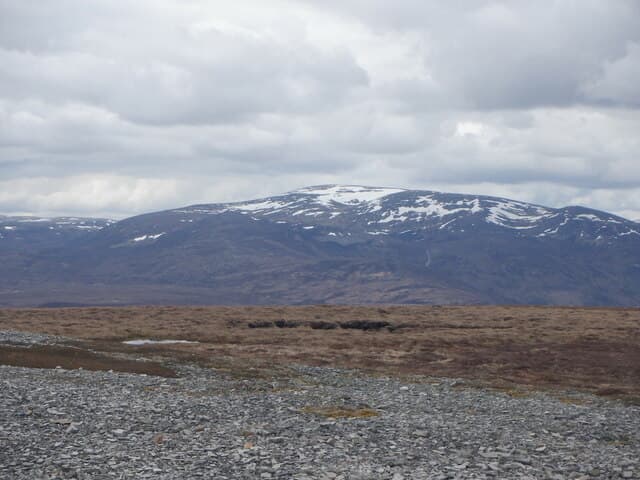
Beinn Bhrotain — "the hill of the mastiff" — is the 1157m Munro that forms the southern wall of the Lairig Ghru pass, looking across to Ben Macdui. The summit is a trig pillar on a wide granite plateau dotted with the Cairngorms' distinctive weathered tors and boulder fields. With its near-neighbour Monadh Mor, the hill forms the southern wall of the Lairig Ghru and overlooks the source of the River Eidart and the head of Glen Geusachan. Long approach distances from any road keep this one of the least-visited high Cairngorms.
Quick facts
- Height
- 1157m/ 3796ft
- Prominence
- 258 m
- Distance
- 19 km
- Ascent
- 1018 m
- Time
- 6–9 hrs
- Grid ref
- NN954922
- Parking
- NO062898
- Nearest city
- Inverness· 60km
- Dogs
- Dogs on lead required near livestockDog-friendly guide ↗
Height and prominence cross-checked against the Database of British and Irish Hills (CC BY).
No GPX track yet
Walked this route? Share your track to help other walkers.
Standard route
Estate track 35% · Open moorland 35% · Summit plateau 30%
The most direct approach starts at the Linn of Dee, taking the Glen Lui track to White Bridge then climbing the Allt Garbh into Coire an t-Sabhail. Around 28km return with 1018m of ascent — bike strongly recommended for the lower 8km of estate track. Almost always combined with Monadh Mor across the broad bealach to the north for a two-Munro day. The Glen Feshie approach from Achlean is shorter but rougher.
Terrain
The Glen Lui and White Bridge tracks are firm gravel — bike to White Bridge to save time. Off the track the climb up the Allt Garbh is on rough heather and stones, with intermittent path. The summit plateau is granite gravel, mossy turf and weathered tors; the trig pillar sits on a small platform. The connecting ground to Monadh Mor is broad and undemanding.
In winter
A genuinely remote winter Munro. The long approach distances make daylight a real constraint. The plateau is a featureless snow plain in poor visibility and the rims of Glen Geusachan are corniced for much of the season. Carry full kit, plan bearings precisely and consider an overnight at Corrour bothy to break the day. SAIS Northern Cairngorms applies.
This hill is in the Northern Cairngorms SAIS forecast area. Check SAIS forecasts in winter (December–April).
Best time of year
Getting there
- Glasgow3h 48m
- Edinburgh3h 36m
OS maps: OS Landranger 43
Mobile signal: No reception above 900m in the remote southern Cairngorms. Mar Lodge car park has reasonable 4G. The Lairig Ghru and White Bridge approaches are fully out of range. Download Harvey Cairngorms map before setting off.
Current conditions
Daylight Today
- Sunrise
- 04:56
- Sunset
- 21:47
- Civil dawn
- 04:01
- Civil dusk
- 22:42
NOAA Solar Calculator · 23 July 2026
Pair with
Curated multi-hill combinations from Beinn Bhrotain.
Around Beinn Bhrotain on the SCOT network
Getting there, basing yourself, and what to do off the hill.
Beinn Bhrotain — common questions
- How difficult is Beinn Bhrotain?
- Beinn Bhrotain carries a 4/5 (challenging) grade on the OutdoorSCOT scale. Count on about 19km, 1018m of ascent and a 6-9 hour day on the standard route. Terrain: The Glen Lui and White Bridge tracks are firm gravel — bike to White Bridge to save time.
- How prominent is Beinn Bhrotain?
- Beinn Bhrotain has 258m of topographic prominence — the height of its summit above the highest col connecting it to higher ground.
- Where should I park to climb Beinn Bhrotain?
- Standard parking is at NO062898. Check the parking grid reference on an OS map before travel; informal laybys can fill on summer weekends.
- When should I climb Beinn Bhrotain?
- The standard good-weather months for Beinn Bhrotain are May, June, July, August, September, October. Outside those months, expect winter conditions on the high ground — full mountain kit, navigation skills, and a check of the SAIS avalanche forecast for the relevant region.
- Can I bring my dog up Beinn Bhrotain?
- On a lead only — the route crosses ground with livestock or nesting-bird interest.
- What's mobile reception like on Beinn Bhrotain?
- No reception above 900m in the remote southern Cairngorms. Mar Lodge car park has reasonable 4G. The Lairig Ghru and White Bridge approaches are fully out of range. Download Harvey Cairngorms map before setting off.
- Is Beinn Bhrotain safe in winter?
- A genuinely remote winter Munro. The long approach distances make daylight a real constraint. The plateau is a featureless snow plain in poor visibility and the rims of Glen Geusachan are corniced for much of the season. Carry full kit, plan bearings precisely and consider an overnight at Corrour bothy to break the day. SAIS Northern Cairngorms applies.
Get the OutdoorSCOT weekly
One email a week — new route, hill and bothy guides, seasonal conditions and the odd hard-won lesson. No spam, unsubscribe in one click.