Munro · Cairngorms
Glas Maol
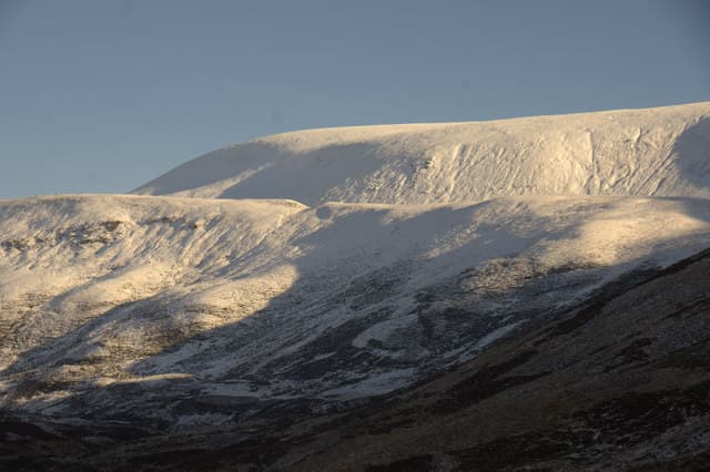
Glas Maol (1067m) is the highest of the four Munros that ring the Cairnwell Pass at Glenshee — the highest paved road pass in Britain at 670m. Together with Creag Leacach, Carn an Tuirc and Cairn of Claise it forms a classic short-day round of four Munros that starts only 400m below the first summit. The hill itself is a broad subarctic plateau where alpine plants survive in deep gravel beds and red deer graze in summer.
Gaelic: “grey-green” · Pronunciation: glass maol
Quick facts
- Height
- 1067.7m/ 3503ft
- Prominence
- 195 m
- Grid ref
- NO166765
- Parking
- NO139780
- Nearest city
- Dundee· 52km
- Dogs
- Dogs on lead required near livestockDog-friendly guide ↗
Height and prominence cross-checked against the Database of British and Irish Hills (CC BY).
No GPX track yet
Walked this route? Share your track to help other walkers.
Standard route
Ski piste / estate track 30% · Open plateau 50% · Summit 20%
The standard route starts from the Glenshee ski-centre car park on the A93. Cross the bridge and climb east over the rough heathery hillside onto Meall Odhar (broad path), continue south-east over the col onto the Glas Maol plateau, then follow the line of fence posts to the summit cairn. Most parties extend west to Creag Leacach for a second Munro. Around 12km with 750m of ascent for the pair; Glas Maol alone is 8km with 530m up — one of the shortest Munro days in Scotland.
Terrain
The first kilometre out of the ski-centre car park crosses ski-runs and broken hillside — boggy in places. Above the col onto Meall Odhar the path becomes a clear track over gravel and short turf. The Glas Maol plateau is a broad, almost flat tableland of mossy turf and gravel where the line of fence-posts provides the only landmark. The Caenlochan corrie rim drops abruptly to the east — keep well back in cloud or wind.
In winter
A regularly snow-bound winter Munro and a popular ski-touring objective. The plateau is exposed to severe winds and cornices form continuously along the Caenlochan corrie rim — keep well clear of edges. The A93 itself is reliably gritted but can close in heavy snow. The Glenshee chairlift is not a public lift for hill-walkers but the ski-area is busy and visible. SAIS Southern Cairngorms applies.
This hill is in the Northern Cairngorms SAIS forecast area. Check SAIS forecasts in winter (December–April).
Best time of year
Getting there
- Glasgow3h 40m
- Edinburgh2h 11m
OS maps: OS Landranger 43
Mobile signal: Good signal at the Glenshee ski centre car park — sits in the A93 valley which has reasonable 4G. Signal weakens to patchy above 1000m on the plateau.
Current conditions
Daylight Today
- Sunrise
- 04:56
- Sunset
- 21:44
- Civil dawn
- 04:00
- Civil dusk
- 22:40
NOAA Solar Calculator · 23 July 2026
Pair with
Curated multi-hill combinations from Glas Maol.
Around Glas Maol on the SCOT network
Getting there, basing yourself, and what to do off the hill.
Getting there: Pitlochry station
Schiehallion, Ben Vrackie, Beinn a Ghlo, Edradour distillery
29km from the hill
tripscot.co.uk
On TripSCOTBase yourself in Ballater
Eastern Cairngorms / Royal Deeside
28km from the hill
tripscot.co.uk
On TasteSCOTAfter the hill: Royal Lochnagar
Balmoral — Queen Victoria's favourite; eastern Cairngorms setting
17km from the hill
tastescot.co.uk
Glas Maol — common questions
- How hard is Glas Maol?
- We grade Glas Maol at 4/5, which puts it in challenging territory. Terrain: The first kilometre out of the ski-centre car park crosses ski-runs and broken hillside — boggy in places.
- How prominent is Glas Maol?
- Glas Maol has 195m of topographic prominence — the height of its summit above the highest col connecting it to higher ground.
- Where should I park to climb Glas Maol?
- Standard parking is at NO139780. Check the parking grid reference on an OS map before travel; informal laybys can fill on summer weekends.
- When should I climb Glas Maol?
- The standard good-weather months for Glas Maol are May, June, July, August, September, October. Outside those months, expect winter conditions on the high ground — full mountain kit, navigation skills, and a check of the SAIS avalanche forecast for the relevant region.
- Can I bring my dog up Glas Maol?
- On a lead only — the route crosses ground with livestock or nesting-bird interest.
- What's mobile reception like on Glas Maol?
- Good signal at the Glenshee ski centre car park — sits in the A93 valley which has reasonable 4G. Signal weakens to patchy above 1000m on the plateau.
- Is Glas Maol safe in winter?
- A regularly snow-bound winter Munro and a popular ski-touring objective. The plateau is exposed to severe winds and cornices form continuously along the Caenlochan corrie rim — keep well clear of edges. The A93 itself is reliably gritted but can close in heavy snow. The Glenshee chairlift is not a public lift for hill-walkers but the ski-area is busy and visible. SAIS Southern Cairngorms applies.
Get the OutdoorSCOT weekly
One email a week — new route, hill and bothy guides, seasonal conditions and the odd hard-won lesson. No spam, unsubscribe in one click.