Munro · Cairngorms
Cairn of Claise
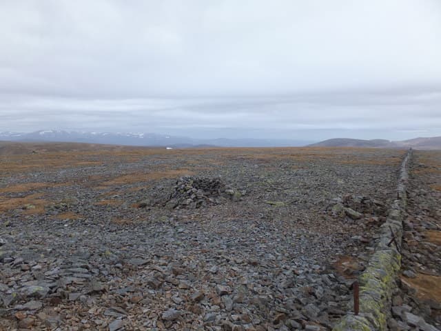
Cairn of Claise (1064m) is a broad, gentle Munro sitting in the middle of the Mounth plateau — the high tableland that links the Glenshee Munros to the southern Cairngorms. It can be reached as part of a longer Mounth round including Càrn an Tuirc, Tom Buidhe and Tolmount, or paired with Glas Maol from the Cairnwell. The summit is a low cairn on the county march between Perth & Kinross and Aberdeenshire, on what was historically one of the great drove roads through the hills.
Quick facts
- Height
- 1063.1m/ 3488ft
- Prominence
- 119 m
- Distance
- 18 km
- Ascent
- 936 m
- Time
- 6–9 hrs
- Grid ref
- NO185788
- Parking
- NO139780
- Nearest city
- Dundee· 53km
- Dogs
- Dogs on lead required near livestockDog-friendly guide ↗
Height and prominence cross-checked against the Database of British and Irish Hills (CC BY).
No GPX track yet
Walked this route? Share your track to help other walkers.
Standard route
Ski infrastructure / track 25% · Open plateau 60% · Summit 15%
The most efficient line is from the Glenshee ski-centre car park as a long four-Munro round taking in Càrn an Tuirc, Cairn of Claise, Glas Maol and Creag Leacach. Climb Càrn an Tuirc directly from the A93 layby at the head of Glen Cluny, traverse south-east across the plateau to Cairn of Claise, then south to Glas Maol and west over Creag Leacach. Return to the ski-centre car park down the Cairnwell pass shoulder. Around 18km with 1100m of cumulative ascent.
Terrain
The Càrn an Tuirc ascent path from the A93 is steep heathery hillside with a faint path that comes and goes. Above 900m the going turns to broad gravel and short turf — easy walking but devoid of landmarks. The plateau between Càrn an Tuirc and Cairn of Claise is over 2km of almost-flat moss and gravel where bearings are essential in cloud. The line of old fence posts is the most reliable handrail.
In winter
A serious winter plateau day. The terrain looks easy in summer but in cloud or whiteout the featureless top is one of the most disorienting places in Scotland. Cornices form along the Caenlochan corrie rim to the south and the Garbh Choire rim to the north. Drifting can be severe; the A93 itself sometimes closes. SAIS Southern Cairngorms applies. Confident compass-and-pace navigation is essential.
This hill is in the Northern Cairngorms SAIS forecast area. Check SAIS forecasts in winter (December–April).
Best time of year
Getting there
- Glasgow3h 43m
- Edinburgh2h 14m
OS maps: OS Landranger 43
Mobile signal: Good signal at the ski centre. The plateau above 1000m has patchy signal. Download the OS map before setting off.
Current conditions
Daylight Today
- Sunrise
- 04:55
- Sunset
- 21:44
- Civil dawn
- 04:00
- Civil dusk
- 22:40
NOAA Solar Calculator · 23 July 2026
Pair with
Curated multi-hill combinations from Cairn of Claise.
Around Cairn of Claise on the SCOT network
Getting there, basing yourself, and what to do off the hill.
Getting there: Pitlochry station
Schiehallion, Ben Vrackie, Beinn a Ghlo, Edradour distillery
32km from the hill
tripscot.co.uk
On TripSCOTBase yourself in Ballater
Eastern Cairngorms / Royal Deeside
25km from the hill
tripscot.co.uk
On TasteSCOTAfter the hill: Royal Lochnagar
Balmoral — Queen Victoria's favourite; eastern Cairngorms setting
15km from the hill
tastescot.co.uk
Cairn of Claise — common questions
- How hard is Cairn of Claise?
- We grade Cairn of Claise at 4/5, which puts it in challenging territory. The usual route is around 18km with 936m of climbing; allow 6-9 hours. Ground conditions: The Càrn an Tuirc ascent path from the A93 is steep heathery hillside with a faint path that comes and goes.
- How much drop does Cairn of Claise have?
- The drop is 119m: measured from the summit of Cairn of Claise down to the saddle joining it to higher terrain.
- Where's the parking for Cairn of Claise?
- Park at NO139780. Double-check the grid reference on an OS map first; informal laybys here fill early in high season.
- What's the best month to climb Cairn of Claise?
- Aim for May, June, July, August, September, October on Cairn of Claise. In the remaining months treat it as a winter hill — full kit, solid navigation, and a look at the relevant SAIS avalanche forecast before you go.
- Can dogs go up Cairn of Claise?
- Dogs are fine on a lead. The route passes livestock or ground-nesting bird habitat, so keep them close throughout.
- Will I get phone signal on Cairn of Claise?
- Good signal at the ski centre. The plateau above 1000m has patchy signal. Download the OS map before setting off.
- Is Cairn of Claise safe in winter?
- A serious winter plateau day. The terrain looks easy in summer but in cloud or whiteout the featureless top is one of the most disorienting places in Scotland. Cornices form along the Caenlochan corrie rim to the south and the Garbh Choire rim to the north. Drifting can be severe; the A93 itself sometimes closes. SAIS Southern Cairngorms applies. Confident compass-and-pace navigation is essential.
Get the OutdoorSCOT weekly
One email a week — new route, hill and bothy guides, seasonal conditions and the odd hard-won lesson. No spam, unsubscribe in one click.