Graham · Cairngorms
Badandun Hill
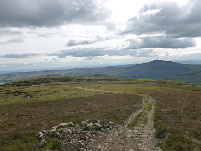
A flat-topped Angus moorland hill on the watershed between Glen Prosen and Glen Isla. The summit trig point looks across a sea of heather toward Mount Blair to the west and the bigger Mounth Munros north of Glen Clova.
Quick facts
- Height
- 740.3m/ 2429ft
- Prominence
- 155 m
- Distance
- 14 km
- Ascent
- 607 m
- Time
- 4–7 hrs
- Grid ref
- NO207678
- Parking
- NO234670
- Nearest city
- Dundee· 42km
- Dogs
- Dogs on lead required near livestockDog-friendly guide ↗
Height and prominence cross-checked against the Database of British and Irish Hills (CC BY).
No GPX track yet
Walked this route? Share your track to help other walkers.
Standard route
estate track 35% · heather moorland 45% · grassy upper slopes 10% · summit area 10%
Park at the road end at Glenmarkie Lodge in Glen Prosen and follow the Land Rover track up Burn of Inchmill, then climb the heathery south-east shoulder onto the broad flat top. The trig is centrally placed.
Terrain
Decent estate vehicle track up the burn, then deep managed heather and bilberry on the upper slopes. Plateau ground is springy peat in places.
In winter
East-facing Angus hill that catches Continental easterlies — frozen heather is a delight to crunch over and snow is generally dry. Wind chill on the open top is the chief winter concern; no avalanche issues at this height.
This hill is in the Northern Cairngorms SAIS forecast area. Check SAIS forecasts in winter (December–April).
Best time of year
Getting there
- Glasgow3h 32m
- Edinburgh2h 0m
OS maps: OS Landranger 44
Mobile signal: Reasonable signal near Kirriemuir; 2 bars on the Angus Glens summit
Current conditions
Daylight Today
- Sunrise
- 04:39
- Sunset
- 21:59
- Civil dawn
- 03:39
- Civil dusk
- 22:59
NOAA Solar Calculator · 13 July 2026
Pair with
Curated multi-hill combinations from Badandun Hill.
Around Badandun Hill on the SCOT network
Getting there, basing yourself, and what to do off the hill.
Getting there: Pitlochry station
Schiehallion, Ben Vrackie, Beinn a Ghlo, Edradour distillery
28km from the hill
tripscot.co.uk
On TripSCOTBase yourself in Pitlochry
Perthshire base — Schiehallion, Beinn a Ghlo, Ben Vrackie
28km from the hill
tripscot.co.uk
On TasteSCOTAfter the hill: Royal Lochnagar
Balmoral — Queen Victoria's favourite; eastern Cairngorms setting
23km from the hill
tastescot.co.uk
Badandun Hill — common questions
- How hard is Badandun Hill?
- We grade Badandun Hill at 4/5, which puts it in challenging territory. The usual route is around 14km with 607m of climbing; allow 4-7 hours. Terrain: Decent estate vehicle track up the burn, then deep managed heather and bilberry on the upper slopes.
- How prominent is Badandun Hill?
- Badandun Hill has 155m of topographic prominence — the height of its summit above the highest col connecting it to higher ground.
- Where should I park to climb Badandun Hill?
- Standard parking is at NO234670. Check the parking grid reference on an OS map before travel; informal laybys can fill on summer weekends.
- When should I climb Badandun Hill?
- The standard good-weather months for Badandun Hill are April, May, June, July, August, September, October. Outside those months, expect winter conditions on the high ground — full mountain kit, navigation skills, and a check of the SAIS avalanche forecast for the relevant region.
- Can I bring my dog up Badandun Hill?
- On a lead only — the route crosses ground with livestock or nesting-bird interest.
- What's mobile reception like on Badandun Hill?
- Reasonable signal near Kirriemuir; 2 bars on the Angus Glens summit
- Is Badandun Hill safe in winter?
- East-facing Angus hill that catches Continental easterlies — frozen heather is a delight to crunch over and snow is generally dry. Wind chill on the open top is the chief winter concern; no avalanche issues at this height.
Get the OutdoorSCOT weekly
One email a week — new route, hill and bothy guides, seasonal conditions and the odd hard-won lesson. No spam, unsubscribe in one click.