Corbett · Cairngorms
Monamenach
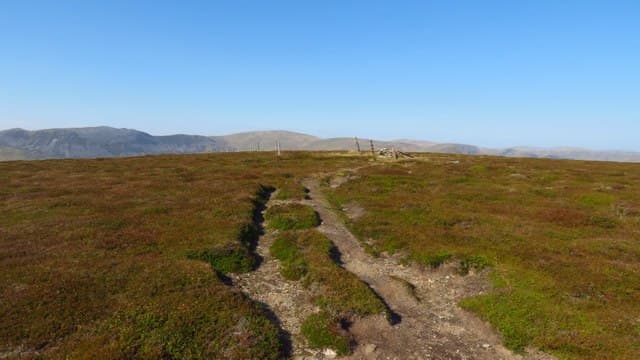
Monamenach — 'the middle mount' — is the 807m Corbett at the head of Glen Isla, central to the Angus Glens. The mountain is the easternmost of the gentler Cairngorm-fringe Corbetts, looking south across the Lowland fringe of Angus and north into the deer-forest of the upper Glen Isla. Drive in from Kirriemuir up the long Glen Isla road — one of the great quiet drives of eastern Scotland — and the mountain rises straight from the road end at Auchavan.
Quick facts
- Height
- 807m/ 2648ft
- Prominence
- 200 m
- Distance
- 11 km
- Ascent
- 580 m
- Time
- 2–5 hrs
- Grid ref
- NO176706
- Parking
- NO191696
- Nearest city
- Dundee· 46km
- Dogs
- Dogs on lead required near livestockDog-friendly guide ↗
Height and prominence cross-checked against the Database of British and Irish Hills (CC BY).
No GPX track yet
Walked this route? Share your track to help other walkers.
Standard route
estate track 25% · heather moorland 45% · grassy upper slopes 20% · summit area 10%
Park at Auchavan at the head of the public road in Glen Isla (NO191696). Cross the Brighty bridge and follow the estate track north up the side of the Glas Burn. After around 3km, branch off the track and head west onto Monamenach's broad east shoulder. A measured plod across moor brings you to the summit cairn. Allow 4–5 hours.
Terrain
Decent estate track on the lower approach. Off the track, a steady climb through short heather and grass leads onto the broad rounded summit — no rocky steps anywhere on the standard line. Drier than the western Corbetts thanks to the Angus Glens rain shadow.
In winter
A friendly winter Corbett — gentle gradients carry no avalanche concerns and the route is easy to follow under cover. The Glen Isla road can be slow when iced but is generally driveable to Auchavan. Cold easterlies from the North Sea coast can be brutal on the open summit; bring full insulation.
This hill is in the Northern Cairngorms SAIS forecast area. Check SAIS forecasts in winter (December–April).
Best time of year
Getting there
- Glasgow3h 33m
- Edinburgh2h 4m
OS maps: OS Landranger 43
Mobile signal: Reasonable signal on this Angus Glens Corbett — around 2 bars on top
Current conditions
Daylight Today
- Sunrise
- 04:39
- Sunset
- 21:59
- Civil dawn
- 03:39
- Civil dusk
- 22:59
NOAA Solar Calculator · 13 July 2026
Around Monamenach on the SCOT network
Getting there, basing yourself, and what to do off the hill.
Getting there: Pitlochry station
Schiehallion, Ben Vrackie, Beinn a Ghlo, Edradour distillery
26km from the hill
tripscot.co.uk
On TripSCOTBase yourself in Pitlochry
Perthshire base — Schiehallion, Beinn a Ghlo, Ben Vrackie
26km from the hill
tripscot.co.uk
On TasteSCOTAfter the hill: Royal Lochnagar
Balmoral — Queen Victoria's favourite; eastern Cairngorms setting
22km from the hill
tastescot.co.uk
Monamenach — common questions
- How hard is Monamenach?
- We grade Monamenach at 2/5, which puts it in moderate territory. The usual route is around 11km with 580m of climbing; allow 2-5 hours. Underfoot: Decent estate track on the lower approach.
- What is Monamenach's prominence?
- 200m of prominence. That's the vertical drop from the summit to the col that links Monamenach to the next higher ground.
- Where do I park for Monamenach?
- Most walkers start from NO191696. Verify the grid reference on an OS map before you set off — space is tight on busy summer weekends.
- When is the best time to climb Monamenach?
- April, May, June, July, August, September, October give the most reliable conditions on Monamenach. Beyond that window the high ground turns wintry: carry full mountain kit, be confident navigating, and check the SAIS avalanche forecast for the area.
- Is Monamenach dog-friendly?
- Yes, but dogs must be kept on a lead — there is livestock or ground-nesting bird interest on the route.
- Is there mobile signal on Monamenach?
- Reasonable signal on this Angus Glens Corbett — around 2 bars on top
- Is Monamenach safe in winter?
- A friendly winter Corbett — gentle gradients carry no avalanche concerns and the route is easy to follow under cover. The Glen Isla road can be slow when iced but is generally driveable to Auchavan. Cold easterlies from the North Sea coast can be brutal on the open summit; bring full insulation.
Get the OutdoorSCOT weekly
One email a week — new route, hill and bothy guides, seasonal conditions and the odd hard-won lesson. No spam, unsubscribe in one click.