Marilyn · Orkney & Shetland
Ward of Bressay
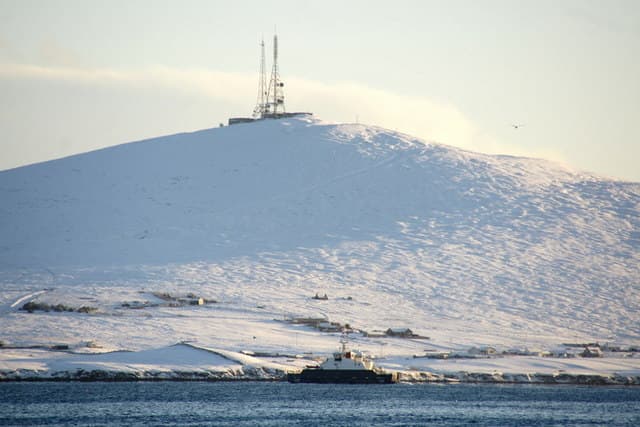
The Ward of Bressay tops the small island that shelters Lerwick harbour, just a few minutes by ferry from the Shetland capital. The 226m summit looks west over the masts and rooftops of Lerwick and east out past the Noss cliffs to the open North Sea.
Quick facts
- Height
- 226m/ 741ft
- Prominence
- 226 m
- Grid ref
- HU 50283 38709
- Dogs
- Dogs on lead required near livestockDog-friendly guide ↗
Height and prominence cross-checked against the Database of British and Irish Hills (CC BY).
No GPX track yet
Walked this route? Share your track to help other walkers.
Standard route
heather moorland 60% · grass slopes 25% · rocky summit 15%
Walkers usually start from the road end above Gunnista or from the church at Bressay, climbing pasture and rough moor to the summit telecoms mast. The track is easy to follow as far as the mast and reasonable underfoot.
Terrain
Grazed grass on the lower slopes gives way to heather and short peat above, with a service track running most of the way to the mast. Boggy patches in hollows but generally drier than open Shetland moor.
In winter
Winters are wet and gusty rather than snowy; salt and rain rather than ice are the usual underfoot issue. The ferry runs year round but Lerwick gales can curtail crossings.
Best time of year
Getting there
- Glasgow14h 44m
- Edinburgh12h 6m
Ferry access
Aberdeen → Lerwick (Shetland)
- Crossing time720 min
- Summer sailingsDaily overnight sailing (Apr–Oct)
- Winter sailingsDaily overnight sailing (Nov–Mar)
- Book ahead14 days
A 12-hour overnight sailing — book a cabin berth. Plan a multi-day Shetland trip; the island is large and the journey is substantial. Flights from Aberdeen/Edinburgh are a faster alternative.
Book on ferry operator ↗OS maps: OS Landranger 4, OS Explorer 466N
Mobile signal: Mixed. EE intermittent up top; better near Lerwick.
Current conditions
Daylight Today
- Sunrise
- 06:29
- Sunset
- 19:31
- Civil dawn
- 05:46
- Civil dusk
- 20:14
NOAA Solar Calculator · 14 September 2026
Ward of Bressay — common questions
- How difficult is Ward of Bressay?
- Ward of Bressay carries a 1/5 (easy) grade on the OutdoorSCOT scale. Ground conditions: Grazed grass on the lower slopes gives way to heather and short peat above, with a service track running most of the way to the mast.
- How much drop does Ward of Bressay have?
- Ward of Bressay's prominence is its full height — 226m — because it is the highest point of its landmass, with no higher ground connected to it. Passing the 150m-drop threshold on all sides is exactly what makes it a Marilyn.
- What's the best month to climb Ward of Bressay?
- Aim for March, April, May, June, July, August, September, October on Ward of Bressay. In the remaining months treat it as a winter hill — full kit, solid navigation, and a look at the relevant SAIS avalanche forecast before you go.
- Can dogs go up Ward of Bressay?
- Dogs are fine on a lead. The route passes livestock or ground-nesting bird habitat, so keep them close throughout.
- Will I get phone signal on Ward of Bressay?
- Mixed. EE intermittent up top; better near Lerwick.
- How do I get the ferry to Ward of Bressay?
- Aberdeen → Lerwick (Shetland). Daily overnight sailing (Apr–Oct) in summer; Daily overnight sailing (Nov–Mar) in winter. Book at least 14 days ahead. A 12-hour overnight sailing — book a cabin berth. Plan a multi-day Shetland trip; the island is large and the journey is substantial. Flights from Aberdeen/Edinburgh are a faster alternative.
- Is Ward of Bressay safe in winter?
- Winters are wet and gusty rather than snowy; salt and rain rather than ice are the usual underfoot issue. The ferry runs year round but Lerwick gales can curtail crossings.
Get the OutdoorSCOT weekly
One email a week — new route, hill and bothy guides, seasonal conditions and the odd hard-won lesson. No spam, unsubscribe in one click.