Marilyn · Outer Hebrides
Uisinis
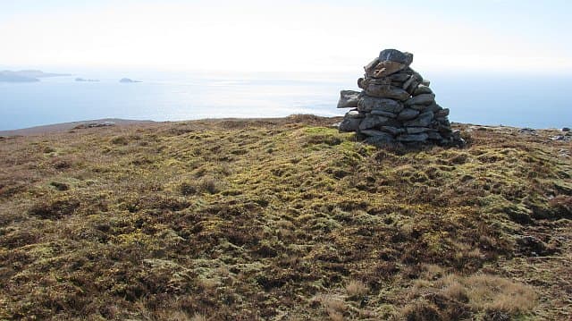
Uisinis is a 374m headland Marilyn at the far southeast corner of the Pairc peninsula in south Lewis, crowned by an unmanned Stevenson lighthouse on the cliff edge a kilometre to the east. The summit has one of the most maritime feels of any Outer Hebridean hill.
Quick facts
- Height
- 374m/ 1227ft
- Prominence
- 229 m
- Grid ref
- NB 33748 05614
- Dogs
- Dogs on lead required near livestockDog-friendly guide ↗
Height and prominence cross-checked against the Database of British and Irish Hills (CC BY).
No GPX track yet
Walked this route? Share your track to help other walkers.
Standard route
blanket bog 50% · Lewisian gneiss 35% · coastal grass 15%
A committing 22-26km return from Eishken, usually 9-11 hours. Many parties walk in via the old stalkers' tracks and stop at Uisinis bothy, making a two-day trip rather than a single push.
Terrain
Estate tracks for the first stretch, then pathless peat, gneiss and clifftop machair. The east cliffs above the Minch are vertical sea cliffs — give them wide berth in poor visibility.
In winter
Almost always tackled with a bothy night to break the distance. Daylight in midwinter is too short for a single-day round; spring is the practical season.
Best time of year
Getting there
- Glasgow8h 58m
- Edinburgh10h 2m
Ferry access
Uig (Skye) → Tarbert (Harris)
- Crossing time105 min
- Summer sailings2 sailings daily (Apr–Oct)
- Winter sailings1 sailing daily (Nov–Mar)
- Book ahead14 days
- Last ferry backCheck CalMac timetable — last sailing to Uig varies seasonally
Drive to Uig on Skye (Skye Bridge from Kyle of Lochalsh), then ferry to Harris. Alternative: Ullapool → Stornoway (Lewis, 2h45) and drive south.
Book on CalMac ↗OS maps: OS Landranger 13, OS Landranger 14, OS Explorer 457
Mobile signal: Poor. Remote Harris peninsula; very limited coverage.
Current conditions
Daylight Today
- Sunrise
- 05:15
- Sunset
- 21:50
- Civil dawn
- 04:20
- Civil dusk
- 22:45
NOAA Solar Calculator · 30 July 2026
Around Uisinis on the SCOT network
Getting there, basing yourself, and what to do off the hill.
Uisinis — common questions
- What difficulty is Uisinis?
- On the OutdoorSCOT scale, Uisinis comes in at 3/5 — moderately challenging. Ground conditions: Estate tracks for the first stretch, then pathless peat, gneiss and clifftop machair.
- How much drop does Uisinis have?
- The drop is 229m: measured from the summit of Uisinis down to the saddle joining it to higher terrain. Passing the 150m-drop threshold on all sides is exactly what makes it a Marilyn.
- What's the best month to climb Uisinis?
- Aim for April, May, June, July, August, September on Uisinis. In the remaining months treat it as a winter hill — full kit, solid navigation, and a look at the relevant SAIS avalanche forecast before you go.
- Can dogs go up Uisinis?
- Dogs are fine on a lead. The route passes livestock or ground-nesting bird habitat, so keep them close throughout.
- Will I get phone signal on Uisinis?
- Poor. Remote Harris peninsula; very limited coverage.
- How do I get the ferry to Uisinis?
- Uig (Skye) → Tarbert (Harris). 2 sailings daily (Apr–Oct) in summer; 1 sailing daily (Nov–Mar) in winter. Book at least 14 days ahead. Drive to Uig on Skye (Skye Bridge from Kyle of Lochalsh), then ferry to Harris. Alternative: Ullapool → Stornoway (Lewis, 2h45) and drive south.
- Is Uisinis safe in winter?
- Almost always tackled with a bothy night to break the distance. Daylight in midwinter is too short for a single-day round; spring is the practical season.
Get the OutdoorSCOT weekly
One email a week — new route, hill and bothy guides, seasonal conditions and the odd hard-won lesson. No spam, unsubscribe in one click.