Marilyn · Outer Hebrides
Beinn Bhreac
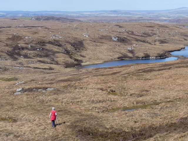
Beinn Bhreac, the speckled hill, sits on the east coast of Lewis between Loch Erisort and Tiumpan Head. The summit at 191m looks out over the Minch toward the Sutherland mountains and on a clear evening makes a fine sunset perch.
Quick facts
- Height
- 191m/ 627ft
- Grid ref
- NB 40681 12105
- Dogs
- Dogs on lead required near livestockDog-friendly guide ↗
No GPX track yet
Walked this route? Share your track to help other walkers.
Standard route
Lewisian gneiss 50% · blanket bog 35% · rough grassland 15%
A short walk from the B895 north of Garrabost or from minor roads near Shulishader takes about two hours return. The route is pathless across knolly gneiss but the distance is short.
Terrain
Classic Lewis knoll-and-lochan ground with bare gneiss outcrops between bog hollows. Short heather and grass on the higher drier shoulders.
In winter
Maritime gales and squally rain dominate; little snow but cloud often grounds out on this exposed eastern coast. Daylight is short from November to January.
Best time of year
Getting there
- Glasgow8h 53m
- Edinburgh10h 52m
OS maps: OS Landranger 14, OS Explorer 457
Mobile signal: Poor. Northern Lewis; very limited coverage.
Current conditions
Daylight Today
- Sunrise
- 04:24
- Sunset
- 22:33
- Civil dawn
- 03:09
- Civil dusk
- 23:48
NOAA Solar Calculator · 27 June 2026
Around Beinn Bhreac on the SCOT network
Getting there, basing yourself, and what to do off the hill.
Beinn Bhreac — common questions
- How hard is Beinn Bhreac?
- Beinn Bhreac is rated 1/5 (easy) on the OutdoorSCOT scale. Terrain: Classic Lewis knoll-and-lochan ground with bare gneiss outcrops between bog hollows.
- When is the best time to climb Beinn Bhreac?
- The standard good-weather months for Beinn Bhreac are April, May, June, July, August, September, October. Outside those months, expect winter conditions on the high ground — full mountain kit, navigation skills, and a check of the SAIS avalanche forecast for the relevant region.
- Can I bring my dog up Beinn Bhreac?
- Yes, but dogs must be kept on a lead — there is livestock or ground-nesting bird interest on the route.
- Is there mobile signal on Beinn Bhreac?
- Poor. Northern Lewis; very limited coverage.
- Is Beinn Bhreac safe in winter?
- Maritime gales and squally rain dominate; little snow but cloud often grounds out on this exposed eastern coast. Daylight is short from November to January.
Get the OutdoorSCOT weekly
One email a week — new route, hill and bothy guides, seasonal conditions and the odd hard-won lesson. No spam, unsubscribe in one click.