Marilyn · Glen Coe & Lochaber
Sgurr na Dubh-chreige
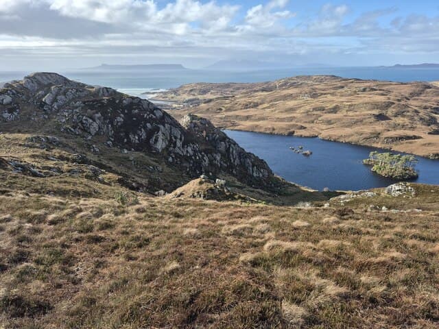
Sgurr na Dubh-chreige — the peak of the black crag — is just 197m high but a fully fledged Marilyn on the rocky Arisaig peninsula near Loch nan Ceall. The summit is a knot of dark gneiss with an outlook over the Small Isles that belies the modest height.
Gaelic: “sharp peak, of the, black” · Pronunciation: skoor na doo chreige
Quick facts
- Height
- 197m/ 646ft
- Prominence
- 164 m
- Grid ref
- NM 69066 93775
- Nearest city
- Fort William· 46km
- Dogs
- Dogs on lead required near livestockDog-friendly guide ↗
Height and prominence cross-checked against the Database of British and Irish Hills (CC BY).
No GPX track yet
Walked this route? Share your track to help other walkers.
Standard route
heather moorland 50% · rocky slopes 35% · grass slopes 15%
From the B8008 near Arisaig village, head north on a track and then over open hillside to the cairn. Short and easy, mostly on grippy gneiss with occasional bog. Under 2 hours and a useful winter day option when the higher hills are unreachable.
Terrain
Knobbly Lewisian gneiss — small slabs and ribs separated by deep heather pockets and tiny lochans. Underfoot dryer than most coastal Marilyns thanks to free-draining rock.
In winter
At 197m on the open coast, winter is effectively a non-issue. The dark gneiss can ice in cold spells; otherwise this is a year-round walk and a useful day when the inland hills are storm-bound.
This hill is in the Glen Coe SAIS forecast area. Check SAIS forecasts in winter (December–April).
Best time of year
Getting there
- Glasgow5h 57m
- Edinburgh7h 16m
OS maps: OS Landranger 40, OS Explorer 398W
Mobile signal: Reasonable. The Arisaig coastal masts give good signal on the summit.
Current conditions
Daylight Today
- Sunrise
- 05:18
- Sunset
- 21:42
- Civil dawn
- 04:26
- Civil dusk
- 22:33
NOAA Solar Calculator · 30 July 2026
Around Sgurr na Dubh-chreige on the SCOT network
Getting there, basing yourself, and what to do off the hill.
Sgurr na Dubh-chreige — common questions
- How hard is Sgurr na Dubh-chreige?
- We grade Sgurr na Dubh-chreige at 1/5, which puts it in easy territory. Terrain: Knobbly Lewisian gneiss — small slabs and ribs separated by deep heather pockets and tiny lochans.
- How prominent is Sgurr na Dubh-chreige?
- Sgurr na Dubh-chreige has 164m of topographic prominence — the height of its summit above the highest col connecting it to higher ground. Marilyns are defined by that measure: at least 150m of drop on all sides.
- When should I climb Sgurr na Dubh-chreige?
- The standard good-weather months for Sgurr na Dubh-chreige are March, April, May, June, July, August, September, October. Outside those months, expect winter conditions on the high ground — full mountain kit, navigation skills, and a check of the SAIS avalanche forecast for the relevant region.
- Can I bring my dog up Sgurr na Dubh-chreige?
- On a lead only — the route crosses ground with livestock or nesting-bird interest.
- What's mobile reception like on Sgurr na Dubh-chreige?
- Reasonable. The Arisaig coastal masts give good signal on the summit.
- Is Sgurr na Dubh-chreige safe in winter?
- At 197m on the open coast, winter is effectively a non-issue. The dark gneiss can ice in cold spells; otherwise this is a year-round walk and a useful day when the inland hills are storm-bound.
Get the OutdoorSCOT weekly
One email a week — new route, hill and bothy guides, seasonal conditions and the odd hard-won lesson. No spam, unsubscribe in one click.