Marilyn · Glen Coe & Lochaber
Beinn nan Cabar
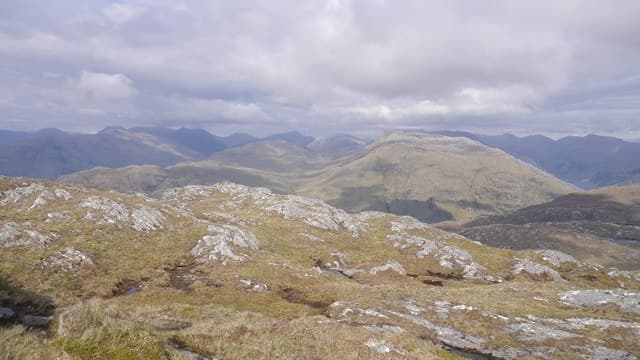
Beinn nan Cabar — the hill of the deer antlers — is a 574m summit on the rough peninsula between Loch Ailort and Loch Beoraid in northern Moidart. The view from the top runs from Eigg and Rum out west to the Knoydart skyline north.
Quick facts
- Height
- 574m/ 1883ft
- Prominence
- 198 m
- Grid ref
- NM 76534 86552
- Nearest city
- Fort William· 36km
- Dogs
- Dogs on lead required near livestockDog-friendly guide ↗
Height and prominence cross-checked against the Database of British and Irish Hills (CC BY).
No GPX track yet
Walked this route? Share your track to help other walkers.
Standard route
heather moorland 55% · rocky slopes 30% · grass slopes 15%
From the A861 near Glenuig, climb through scrubby birch and bracken onto open heather, then follow the broad south-west ridge to the cairn. There is no real path; the ground is the usual Moidart mosaic of slabby gneiss and wet hollows. Around 4 hours.
Terrain
Lewisian gneiss slabs interspersed with deep heather and bracken-filled hollows. The slabs give grippy walking in the dry but become slick and treacherous in the wet. Bog around the small lochans on the plateau.
In winter
A coastal Moidart hill at 574m. Snow comes and goes with the weather; the rock slabs glaze quickly and offer poor purchase under verglas. Spikes useful; full crampons rarely justified at this altitude.
This hill is in the Glen Coe SAIS forecast area. Check SAIS forecasts in winter (December–April).
Best time of year
Getting there
- Glasgow5h 35m
- Edinburgh7h 54m
OS maps: OS Landranger 40, OS Explorer 398W
Mobile signal: Patchy. Coastal masts at Glenuig give signal at the road end; the upper hill is mostly dead.
Current conditions
Daylight Today
- Sunrise
- 05:18
- Sunset
- 21:41
- Civil dawn
- 04:26
- Civil dusk
- 22:32
NOAA Solar Calculator · 30 July 2026
Around Beinn nan Cabar on the SCOT network
Getting there, basing yourself, and what to do off the hill.
Beinn nan Cabar — common questions
- How difficult is Beinn nan Cabar?
- Beinn nan Cabar carries a 2/5 (moderate) grade on the OutdoorSCOT scale. Ground conditions: Lewisian gneiss slabs interspersed with deep heather and bracken-filled hollows.
- How much drop does Beinn nan Cabar have?
- The drop is 198m: measured from the summit of Beinn nan Cabar down to the saddle joining it to higher terrain. Passing the 150m-drop threshold on all sides is exactly what makes it a Marilyn.
- What's the best month to climb Beinn nan Cabar?
- Aim for March, April, May, June, July, August, September, October on Beinn nan Cabar. In the remaining months treat it as a winter hill — full kit, solid navigation, and a look at the relevant SAIS avalanche forecast before you go.
- Can dogs go up Beinn nan Cabar?
- Dogs are fine on a lead. The route passes livestock or ground-nesting bird habitat, so keep them close throughout.
- Will I get phone signal on Beinn nan Cabar?
- Patchy. Coastal masts at Glenuig give signal at the road end; the upper hill is mostly dead.
- Is Beinn nan Cabar safe in winter?
- A coastal Moidart hill at 574m. Snow comes and goes with the weather; the rock slabs glaze quickly and offer poor purchase under verglas. Spikes useful; full crampons rarely justified at this altitude.
Get the OutdoorSCOT weekly
One email a week — new route, hill and bothy guides, seasonal conditions and the odd hard-won lesson. No spam, unsubscribe in one click.