Marilyn · Knoydart
Druim na Cluain-airighe
Druim na Cluain-airighe — the ridge of the shieling meadow — is a 517m hill on the western tip of the Knoydart peninsula, looking out across the Sound of Sleat to Skye. The position is everything: low altitude, but a horizon that spans the inner Hebrides.
Quick facts
- Height
- 517m/ 1696ft
- Prominence
- 382 m
- Grid ref
- NG 75164 03454
- Nearest city
- Fort William· 46km
- Dogs
- Dogs on lead required near livestockDog-friendly guide ↗
Height and prominence cross-checked against the Database of British and Irish Hills (CC BY).
No GPX track yet
Walked this route? Share your track to help other walkers.
Standard route
heather moorland 65% · grass slopes 25% · rocky summit 10%
Reached from Inverie after the Mallaig ferry: take the coastal track west toward Sandaig and break uphill onto open hillside. Heather and old grazing dykes underfoot. Around 3 hours up and down once you are off the boat.
Terrain
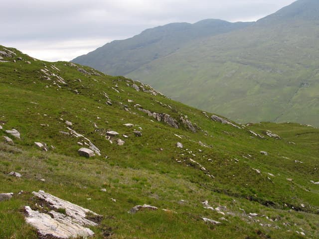
Soft coastal turf with bracken hollows and patches of bog. Old shieling walls and lazybeds testify to the cleared population of Knoydart. The bedrock breaks through as small Lewisian gneiss outcrops near the cairn.
In winter
A coastal 517m hill that almost never holds proper snow. Winter mainly means short daylight and changeable weather; the practical limit is fitting the walk between the morning and afternoon ferry sailings to Mallaig.
Kit for this: the winter Munro kit list · which boots take crampons
Best time of year
Getting there
- Glasgow5h 54m
- Edinburgh7h 8m
Ferry access
Mallaig → Inverie (Knoydart)
- Crossing time45 min
- Summer sailingsDaily: 4 return sailings Mon–Sat, 3 on Sunday (Apr–Oct, Western Isles Cruises 2026–27 timetable)
- Winter sailingsDaily: 4 Mon–Fri, 2 on Sat and Sun (Nov–Mar); no service 25–26 Dec or 1–2 Jan
- Last ferry backLast boat from Inverie 18:30, except winter Sundays (15:00). The first and last sailing each day must be booked online in advance; all sailings weather dependent
Knoydart is a roadless peninsula — not an island, but accessible only by ferry or a very long walk (18+ km over difficult terrain). Day trips to Sgùrr Coire Choinnichean are achievable in summer. For Ladhar Bheinn, base yourself overnight at Inverie.
Book on ferry operator ↗OS maps: OS Landranger 33, OS Explorer 413S
Mobile signal: Patchy. Reception across to Skye masts from the summit; Inverie has limited village signal.
Current conditions
Daylight Today
- Sunrise
- 07:24
- Sunset
- 16:49
- Civil dawn
- 06:44
- Civil dusk
- 17:30
NOAA Solar Calculator · 28 October 2026
Around Druim na Cluain-airighe on the SCOT network
Getting there, basing yourself, and what to do off the hill.
Druim na Cluain-airighe — common questions
- What difficulty is Druim na Cluain-airighe?
- On the OutdoorSCOT scale, Druim na Cluain-airighe comes in at 2/5 — moderate. Underfoot: Soft coastal turf with bracken hollows and patches of bog.
- What is Druim na Cluain-airighe's prominence?
- 382m of prominence. That's the vertical drop from the summit to the col that links Druim na Cluain-airighe to the next higher ground. That drop is what qualifies it as a Marilyn — a hill with at least 150m of descent on every side.
- When is the best time to climb Druim na Cluain-airighe?
- March, April, May, June, July, August, September, October give the most reliable conditions on Druim na Cluain-airighe. Beyond that window the high ground turns wintry: carry full mountain kit, be confident navigating, and check the SAIS avalanche forecast for the area.
- Is Druim na Cluain-airighe dog-friendly?
- Yes, but dogs must be kept on a lead — there is livestock or ground-nesting bird interest on the route.
- Is there mobile signal on Druim na Cluain-airighe?
- Patchy. Reception across to Skye masts from the summit; Inverie has limited village signal.
- How do I get the ferry to Druim na Cluain-airighe?
- Mallaig → Inverie (Knoydart). Daily: 4 return sailings Mon–Sat, 3 on Sunday (Apr–Oct, Western Isles Cruises 2026–27 timetable) in summer; Daily: 4 Mon–Fri, 2 on Sat and Sun (Nov–Mar); no service 25–26 Dec or 1–2 Jan in winter. Knoydart is a roadless peninsula — not an island, but accessible only by ferry or a very long walk (18+ km over difficult terrain). Day trips to Sgùrr Coire Choinnichean are achievable in summer. For Ladhar Bheinn, base yourself overnight at Inverie.
- Is Druim na Cluain-airighe safe in winter?
- A coastal 517m hill that almost never holds proper snow. Winter mainly means short daylight and changeable weather; the practical limit is fitting the walk between the morning and afternoon ferry sailings to Mallaig.
Get the OutdoorSCOT weekly
One email a week — new route, hill and bothy guides, seasonal conditions and the odd hard-won lesson. No spam, unsubscribe in one click.