Marilyn · Torridon
Seana Mheallan
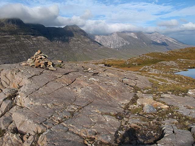
Seana Mheallan — the old little hill — rises to 437m at NG 928 551 directly south of Annat at the head of Loch Torridon. Despite the diminutive Gaelic name, the rocky knolls and lochans on its summit area give the kind of small-scale interest that the bigger Torridon hills lack.
Quick facts
- Height
- 437m/ 1434ft
- Prominence
- 242 m
- Grid ref
- NG 92884 55108
- Nearest city
- Inverness· 74km
- Dogs
- Dogs on lead required near livestockDog-friendly guide ↗
Height and prominence cross-checked against the Database of British and Irish Hills (CC BY).
No GPX track yet
Walked this route? Share your track to help other walkers.
Standard route
heather and bog 65% · grass slopes 25% · rocky summit 10%
Start from the Torridon Countryside Centre or the road south of Annat. A path leads onto the lower hillside; thereafter it is straightforward navigation by line of sight to the summit. Around 3 hours.
Terrain
Lewisian gneiss knolls everywhere — small rocky bumps with peat bogs and tarns between. Pick a line round the wettest hollows; the rock itself is grippy enough.
In winter
Sits below the snowline of the great Torridon peaks but inherits their wild weather. The knolly terrain becomes confusing when half-hidden under fresh snow. Daylight, route choice and a watchful eye on cloud are the keys.
This hill is in the Torridon SAIS forecast area. Check SAIS forecasts in winter (December–April).
Best time of year
Getting there
- Glasgow5h 21m
- Edinburgh7h 10m
OS maps: OS Landranger 25, OS Explorer 429, OS Explorer 433
Mobile signal: Poor. Remote Ross-shire/Sutherland; limited coverage.
Current conditions
Daylight Today
- Sunrise
- 05:13
- Sunset
- 21:44
- Civil dawn
- 04:20
- Civil dusk
- 22:37
NOAA Solar Calculator · 30 July 2026
Around Seana Mheallan on the SCOT network
Getting there, basing yourself, and what to do off the hill.
Seana Mheallan — common questions
- How hard is Seana Mheallan?
- We grade Seana Mheallan at 1/5, which puts it in easy territory. Terrain: Lewisian gneiss knolls everywhere — small rocky bumps with peat bogs and tarns between.
- How prominent is Seana Mheallan?
- Seana Mheallan has 242m of topographic prominence — the height of its summit above the highest col connecting it to higher ground. Marilyns are defined by that measure: at least 150m of drop on all sides.
- When should I climb Seana Mheallan?
- The standard good-weather months for Seana Mheallan are March, April, May, June, July, August, September, October. Outside those months, expect winter conditions on the high ground — full mountain kit, navigation skills, and a check of the SAIS avalanche forecast for the relevant region.
- Can I bring my dog up Seana Mheallan?
- On a lead only — the route crosses ground with livestock or nesting-bird interest.
- What's mobile reception like on Seana Mheallan?
- Poor. Remote Ross-shire/Sutherland; limited coverage.
- Is Seana Mheallan safe in winter?
- Sits below the snowline of the great Torridon peaks but inherits their wild weather. The knolly terrain becomes confusing when half-hidden under fresh snow. Daylight, route choice and a watchful eye on cloud are the keys.
Get the OutdoorSCOT weekly
One email a week — new route, hill and bothy guides, seasonal conditions and the odd hard-won lesson. No spam, unsubscribe in one click.