Marilyn · Torridon
Ben Shieldaig
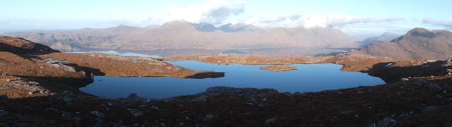
Ben Shieldaig stands at 534m at NG 833 524 directly above the village of Shieldaig on Loch Torridon. Its name borrows the Norse-origin word for the herring loch below, and the hill carries fragments of the largest native Scots pine wood in north-west Scotland on its flanks.
Quick facts
- Height
- 534m/ 1752ft
- Prominence
- 403 m
- Grid ref
- NG 83363 52393
- Nearest city
- Inverness· 83km
- Dogs
- Dogs on lead required near livestockDog-friendly guide ↗
Height and prominence cross-checked against the Database of British and Irish Hills (CC BY).
No GPX track yet
Walked this route? Share your track to help other walkers.
Standard route
Torridonian sandstone 40% · heather moorland 40% · rocky summit 20%
From the centre of Shieldaig, take the road south then bear east onto a stalkers' path that climbs through pine wood before opening onto heather slopes. The summit ridge gives one of the finest Torridon panoramas. Around 4 hours.
Terrain
Pine wood at the start gives way to terraced Torridonian sandstone steps, then short heather across the broad ridge. A few rocky steps near the highest point are easily picked through.
In winter
Lower than the Torridon Munros but on the same weather front — snow can plaster the summit slabs in days of north-westerly storm. The sandstone terraces become slippery when iced. Crampons sometimes useful on the upper ridge.
This hill is in the Torridon SAIS forecast area. Check SAIS forecasts in winter (December–April).
Best time of year
Getting there
- Glasgow6h 33m
- Edinburgh7h 28m
OS maps: OS Landranger 24, OS Explorer 428N
Mobile signal: Poor. Remote Torridon/Wester Ross; limited coverage.
Current conditions
Daylight Today
- Sunrise
- 05:14
- Sunset
- 21:44
- Civil dawn
- 04:21
- Civil dusk
- 22:37
NOAA Solar Calculator · 30 July 2026
Around Ben Shieldaig on the SCOT network
Getting there, basing yourself, and what to do off the hill.
Ben Shieldaig — common questions
- How difficult is Ben Shieldaig?
- Ben Shieldaig carries a 2/5 (moderate) grade on the OutdoorSCOT scale. Ground conditions: Pine wood at the start gives way to terraced Torridonian sandstone steps, then short heather across the broad ridge.
- How much drop does Ben Shieldaig have?
- The drop is 403m: measured from the summit of Ben Shieldaig down to the saddle joining it to higher terrain. Passing the 150m-drop threshold on all sides is exactly what makes it a Marilyn.
- What's the best month to climb Ben Shieldaig?
- Aim for March, April, May, June, July, August, September, October on Ben Shieldaig. In the remaining months treat it as a winter hill — full kit, solid navigation, and a look at the relevant SAIS avalanche forecast before you go.
- Can dogs go up Ben Shieldaig?
- Dogs are fine on a lead. The route passes livestock or ground-nesting bird habitat, so keep them close throughout.
- Will I get phone signal on Ben Shieldaig?
- Poor. Remote Torridon/Wester Ross; limited coverage.
- Is Ben Shieldaig safe in winter?
- Lower than the Torridon Munros but on the same weather front — snow can plaster the summit slabs in days of north-westerly storm. The sandstone terraces become slippery when iced. Crampons sometimes useful on the upper ridge.
Get the OutdoorSCOT weekly
One email a week — new route, hill and bothy guides, seasonal conditions and the odd hard-won lesson. No spam, unsubscribe in one click.