Marilyn · Arran
Sail Chalmadale
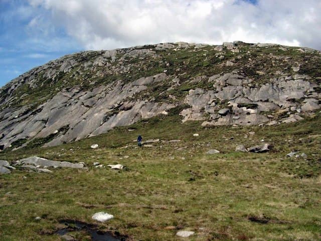
Heel of Chalmadale, a 480m granite spur on the wild north-western flank of Arran. The hill rises directly above Glen Catacol with an outlook across Kilbrannan Sound to Kintyre — a surprisingly remote feeling for an island summit.
Quick facts
- Height
- 479.7m/ 1574ft
- Prominence
- 151 m
- Grid ref
- NR 91434 40098
- Nearest city
- Glasgow· 72km
- Dogs
- Dogs on lead required near livestockDog-friendly guide ↗
Height and prominence cross-checked against the Database of British and Irish Hills (CC BY).
No GPX track yet
Walked this route? Share your track to help other walkers.
Standard route
heather moorland 50% · granite rock 35% · grass slopes 15%
From Catacol on the Lochranza-Pirnmill coast road, take the path up Glen Catacol then leave it to climb the broad south-west ridge. Around 10km return and 550m of ascent; four hours is enough at a steady pace.
Terrain
A clear glen path on the lower section gives way to trackless heather and granite boulder fields above. The summit ridge is rocky underfoot — turn an ankle and it is a long way home.
In winter
Snow drifts deep against the eastern crags from January and the upper slopes can hold ice for weeks. North-westerly winds funnel up Glen Catacol with surprising venom.
Best time of year
Getting there
- Glasgow3h 49m
- Edinburgh6h 34m
Ferry access
Ardrossan → Brodick
- Crossing time55 min
- Summer sailingsUp to 6 sailings daily (Apr–Oct)
- Winter sailings3–4 sailings daily (Nov–Mar)
- Book ahead7 days
- Last ferry backCheck CalMac timetable — last departure varies seasonally
Foot passengers welcome without booking. Book vehicle space well in advance in summer. A seasonal alternative runs Claonaig → Lochranza (30 min) in summer.
Book on CalMac ↗OS maps: OS Landranger 62, OS Landranger 69, OS Explorer 361N
Mobile signal: Poor. Arran interior; EE intermittent at best on this summit.
Current conditions
Daylight Today
- Sunrise
- 05:23
- Sunset
- 21:32
- Civil dawn
- 04:35
- Civil dusk
- 22:21
NOAA Solar Calculator · 30 July 2026
Around Sail Chalmadale on the SCOT network
Getting there, basing yourself, and what to do off the hill.
Getting there: Ardrossan Harbour station
Ferry to Brodick (Arran) — Goat Fell, Arran ridge
31km from the hill
tripscot.co.uk
On TripSCOTBase yourself in Brodick
Arran base — Goat Fell, Glen Rosa, the Arran ridge
11km from the hill
tripscot.co.uk
On TasteSCOTAfter the hill: Arran
Lochranza — northern Arran; revived in 1995; rich sherried releases
11km from the hill
tastescot.co.uk
Sail Chalmadale — common questions
- What difficulty is Sail Chalmadale?
- On the OutdoorSCOT scale, Sail Chalmadale comes in at 1/5 — easy. Underfoot: A clear glen path on the lower section gives way to trackless heather and granite boulder fields above.
- What is Sail Chalmadale's prominence?
- 151m of prominence. That's the vertical drop from the summit to the col that links Sail Chalmadale to the next higher ground. That drop is what qualifies it as a Marilyn — a hill with at least 150m of descent on every side.
- When is the best time to climb Sail Chalmadale?
- March, April, May, June, July, August, September, October give the most reliable conditions on Sail Chalmadale. Beyond that window the high ground turns wintry: carry full mountain kit, be confident navigating, and check the SAIS avalanche forecast for the area.
- Is Sail Chalmadale dog-friendly?
- Yes, but dogs must be kept on a lead — there is livestock or ground-nesting bird interest on the route.
- Is there mobile signal on Sail Chalmadale?
- Poor. Arran interior; EE intermittent at best on this summit.
- How do I get the ferry to Sail Chalmadale?
- Ardrossan → Brodick. Up to 6 sailings daily (Apr–Oct) in summer; 3–4 sailings daily (Nov–Mar) in winter. Book at least 7 days ahead. Foot passengers welcome without booking. Book vehicle space well in advance in summer. A seasonal alternative runs Claonaig → Lochranza (30 min) in summer.
- Is Sail Chalmadale safe in winter?
- Snow drifts deep against the eastern crags from January and the upper slopes can hold ice for weeks. North-westerly winds funnel up Glen Catacol with surprising venom.
Get the OutdoorSCOT weekly
One email a week — new route, hill and bothy guides, seasonal conditions and the odd hard-won lesson. No spam, unsubscribe in one click.