Sub-Marilyn · Arran
Beinn Tarsuinn
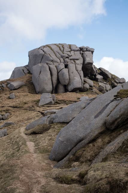
Transverse Hill, a 556m granite top forming the western wall of Glen Rosa on Arran. Despite sitting in the shadow of A'Chir and Cir Mhor, it offers one of the finest mid-grade summits on Arran with serious views of the Sleeping Warrior skyline.
Quick facts
- Height
- 555.9m/ 1824ft
- Prominence
- 149 m
- Grid ref
- NR 93072 45169
- Nearest city
- Glasgow· 69km
- Dogs
- Dogs on lead required near livestockDog-friendly guide ↗
Sub-Marilyn: 149m of drop — misses the 150m Marilyn cut by 1m. We keep it on the list as a near-miss.
Height and prominence cross-checked against the Database of British and Irish Hills (CC BY).
No GPX track yet
Walked this route? Share your track to help other walkers.
Standard route
heather moorland 50% · granite rock 35% · grass slopes 15%
From Glen Rosa, gain the col below Beinn a'Chliabhain, then follow the broad heather ridge north-west to the summit. Around 14km return with 800m of ascent; budget five to six hours and take care of the ankle-twisting boulders near the top.
Terrain
Glen Rosa's stalkers' path is excellent for the first few kilometres; thereafter rough granite slabs, heather and exposed bedrock. The summit area is awkward boulder-strewn ground.
In winter
A genuine winter outing — snow accumulates in the corries from December and ice forms readily on the granite. Ridge crossings can be exposed to north-westerly gales sweeping in from the Atlantic.
Best time of year
Getting there
- Glasgow3h 44m
- Edinburgh5h 29m
Ferry access
Ardrossan → Brodick
- Crossing time55 min
- Summer sailingsUp to 6 sailings daily (Apr–Oct)
- Winter sailings3–4 sailings daily (Nov–Mar)
- Book ahead7 days
- Last ferry backCheck CalMac timetable — last departure varies seasonally
Foot passengers welcome without booking. Book vehicle space well in advance in summer. A seasonal alternative runs Claonaig → Lochranza (30 min) in summer.
Book on CalMac ↗OS maps: OS Landranger 62, OS Landranger 69, OS Explorer 361N
Mobile signal: Poor. Glen Rosa loses signal quickly; the summit has no coverage. Plan accordingly.
Current conditions
Daylight Today
- Sunrise
- 05:23
- Sunset
- 21:33
- Civil dawn
- 04:34
- Civil dusk
- 22:21
NOAA Solar Calculator · 30 July 2026
Around Beinn Tarsuinn on the SCOT network
Getting there, basing yourself, and what to do off the hill.
Getting there: Ardrossan Harbour station
Ferry to Brodick (Arran) — Goat Fell, Arran ridge
29km from the hill
tripscot.co.uk
On TripSCOTBase yourself in Brodick
Arran base — Goat Fell, Glen Rosa, the Arran ridge
13km from the hill
tripscot.co.uk
On TasteSCOTAfter the hill: Arran
Lochranza — northern Arran; revived in 1995; rich sherried releases
6km from the hill
tastescot.co.uk
Beinn Tarsuinn — common questions
- How hard is Beinn Tarsuinn?
- We grade Beinn Tarsuinn at 2/5, which puts it in moderate territory. Underfoot: Glen Rosa's stalkers' path is excellent for the first few kilometres; thereafter rough granite slabs, heather and exposed bedrock.
- What is Beinn Tarsuinn's prominence?
- 149m of prominence. That's the vertical drop from the summit to the col that links Beinn Tarsuinn to the next higher ground. That leaves it 1m short of the 150m drop a Marilyn needs — DoBIH classes it a sub-Marilyn, a near-miss rather than a full Marilyn.
- When is the best time to climb Beinn Tarsuinn?
- March, April, May, June, July, August, September, October give the most reliable conditions on Beinn Tarsuinn. Beyond that window the high ground turns wintry: carry full mountain kit, be confident navigating, and check the SAIS avalanche forecast for the area.
- Is Beinn Tarsuinn dog-friendly?
- Yes, but dogs must be kept on a lead — there is livestock or ground-nesting bird interest on the route.
- Is there mobile signal on Beinn Tarsuinn?
- Poor. Glen Rosa loses signal quickly; the summit has no coverage. Plan accordingly.
- How do I get the ferry to Beinn Tarsuinn?
- Ardrossan → Brodick. Up to 6 sailings daily (Apr–Oct) in summer; 3–4 sailings daily (Nov–Mar) in winter. Book at least 7 days ahead. Foot passengers welcome without booking. Book vehicle space well in advance in summer. A seasonal alternative runs Claonaig → Lochranza (30 min) in summer.
- Is Beinn Tarsuinn safe in winter?
- A genuine winter outing — snow accumulates in the corries from December and ice forms readily on the granite. Ridge crossings can be exposed to north-westerly gales sweeping in from the Atlantic.
Get the OutdoorSCOT weekly
One email a week — new route, hill and bothy guides, seasonal conditions and the odd hard-won lesson. No spam, unsubscribe in one click.