Marilyn · Arran
Meall nan Damh
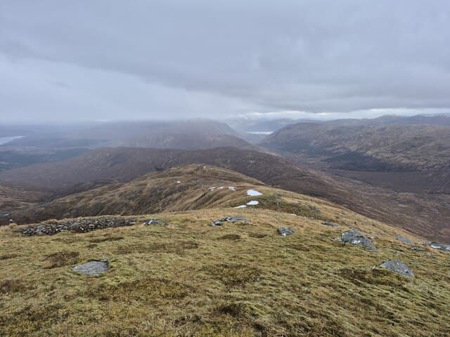
Hill of the Stags, the highest summit of the long Knapdale ridge looking eastward across Kilbrannan Sound to Arran. A quiet, little-walked hill that rewards the patient with a striking ridge skyline of granite peaks across the water.
Gaelic: “rounded hill, of the, stag” · Pronunciation: myowl nan dav
Quick facts
- Height
- 570m/ 1870ft
- Prominence
- 178 m
- Grid ref
- NR 91091 46897
- Nearest city
- Glasgow· 70km
- Dogs
- Dogs on lead required near livestockDog-friendly guide ↗
Height and prominence cross-checked against the Database of British and Irish Hills (CC BY).
No GPX track yet
Walked this route? Share your track to help other walkers.
Standard route
heather and bog 65% · grass slopes 25% · rocky summit 10%
Best approached from the B8024 west of Tarbert, following forestry tracks then breaking out onto open hillside on the south-east shoulder. Around 9km and 600m of ascent — three to four hours for a fit walker.
Terrain
Conifer plantation, felled blocks and deer fences on the lower slopes; trackless heather and tussock above. The summit area is bog and grass with a small cairn.
In winter
Snow rarely settles deep on the Knapdale tops but the forestry tracks ice quickly. The biggest hazard is the felled forestry — brash piles are treacherous when frozen.
Best time of year
Getting there
- Glasgow3h 49m
- Edinburgh6h 34m
Ferry access
Ardrossan → Brodick
- Crossing time55 min
- Summer sailingsUp to 6 sailings daily (Apr–Oct)
- Winter sailings3–4 sailings daily (Nov–Mar)
- Book ahead7 days
- Last ferry backCheck CalMac timetable — last departure varies seasonally
Foot passengers welcome without booking. Book vehicle space well in advance in summer. A seasonal alternative runs Claonaig → Lochranza (30 min) in summer.
Book on CalMac ↗OS maps: OS Landranger 62, OS Landranger 69, OS Explorer 361N
Mobile signal: Weak. no EE bars on this remote Knapdale hill; nearest coverage near Lochgilphead.
Current conditions
Daylight Today
- Sunrise
- 05:23
- Sunset
- 21:33
- Civil dawn
- 04:34
- Civil dusk
- 22:21
NOAA Solar Calculator · 30 July 2026
Around Meall nan Damh on the SCOT network
Getting there, basing yourself, and what to do off the hill.
Getting there: Largs station
Cumbrae ferry; Ayrshire coast; Nardini's
32km from the hill
tripscot.co.uk
On TripSCOTBase yourself in Brodick
Arran base — Goat Fell, Glen Rosa, the Arran ridge
15km from the hill
tripscot.co.uk
On TasteSCOTAfter the hill: Arran
Lochranza — northern Arran; revived in 1995; rich sherried releases
4km from the hill
tastescot.co.uk
Meall nan Damh — common questions
- What difficulty is Meall nan Damh?
- On the OutdoorSCOT scale, Meall nan Damh comes in at 2/5 — moderate. Terrain: Conifer plantation, felled blocks and deer fences on the lower slopes; trackless heather and tussock above.
- How prominent is Meall nan Damh?
- Meall nan Damh has 178m of topographic prominence — the height of its summit above the highest col connecting it to higher ground. Marilyns are defined by that measure: at least 150m of drop on all sides.
- When should I climb Meall nan Damh?
- The standard good-weather months for Meall nan Damh are March, April, May, June, July, August, September, October. Outside those months, expect winter conditions on the high ground — full mountain kit, navigation skills, and a check of the SAIS avalanche forecast for the relevant region.
- Can I bring my dog up Meall nan Damh?
- On a lead only — the route crosses ground with livestock or nesting-bird interest.
- What's mobile reception like on Meall nan Damh?
- Weak. no EE bars on this remote Knapdale hill; nearest coverage near Lochgilphead.
- How do I get the ferry to Meall nan Damh?
- Ardrossan → Brodick. Up to 6 sailings daily (Apr–Oct) in summer; 3–4 sailings daily (Nov–Mar) in winter. Book at least 7 days ahead. Foot passengers welcome without booking. Book vehicle space well in advance in summer. A seasonal alternative runs Claonaig → Lochranza (30 min) in summer.
- Is Meall nan Damh safe in winter?
- Snow rarely settles deep on the Knapdale tops but the forestry tracks ice quickly. The biggest hazard is the felled forestry — brash piles are treacherous when frozen.
Get the OutdoorSCOT weekly
One email a week — new route, hill and bothy guides, seasonal conditions and the odd hard-won lesson. No spam, unsubscribe in one click.