Marilyn · Arran
A' Chruach
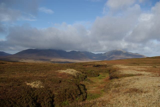
The Stack, the high point of southern Arran's rolling moorland country. Quite different in character to the granite peaks of north Arran — gentle moorland whalebacks here rather than rocky aretes — with sweeping panoramas over the Firth of Clyde to Ailsa Craig.
Quick facts
- Height
- 512.5m/ 1681ft
- Grid ref
- NR 96976 33546
- Nearest city
- Glasgow· 70km
- Dogs
- Dogs on lead required near livestockDog-friendly guide ↗
No GPX track yet
Walked this route? Share your track to help other walkers.
Standard route
rough grassland 55% · heather 30% · rocky summit 15%
Most parties start from the Ross Road and follow forestry roads inland before striking up the open moor to the summit trig. A relaxed half-day of around 10km return; an obvious objective to combine with a beach walk on the Arran south coast.
Terrain
Forestry road on the lower section is firm; thereafter open moorland with patches of bog. The summit gives short-cropped grass and easy walking once the heather is left behind.
In winter
Snow lies only briefly on these southern Arran moors but persistent rain leaves the bogs saturated for much of the winter. Pick a settled day and add gaiters.
Best time of year
Getting there
- Glasgow3h 38m
- Edinburgh5h 21m
Ferry access
Ardrossan → Brodick
- Crossing time55 min
- Summer sailingsUp to 6 sailings daily (Apr–Oct)
- Winter sailings3–4 sailings daily (Nov–Mar)
- Book ahead7 days
- Last ferry backCheck CalMac timetable — last departure varies seasonally
Foot passengers welcome without booking. Book vehicle space well in advance in summer. A seasonal alternative runs Claonaig → Lochranza (30 min) in summer.
Book on CalMac ↗OS maps: OS Landranger 68, OS Landranger 69, OS Explorer 361N, OS Explorer 361S
Mobile signal: Good. South Arran; EE reliable.
Current conditions
Daylight Today
- Sunrise
- 04:40
- Sunset
- 22:08
- Civil dawn
- 03:39
- Civil dusk
- 23:08
NOAA Solar Calculator · 27 June 2026
Around A' Chruach on the SCOT network
Getting there, basing yourself, and what to do off the hill.
Getting there: Ardrossan Harbour station
Ferry to Brodick (Arran) — Goat Fell, Arran ridge
27km from the hill
tripscot.co.uk
On TripSCOTBase yourself in Brodick
Arran base — Goat Fell, Glen Rosa, the Arran ridge
6km from the hill
tripscot.co.uk
On TasteSCOTAfter the hill: Arran
Lochranza — northern Arran; revived in 1995; rich sherried releases
18km from the hill
tastescot.co.uk
A' Chruach — common questions
- How hard is A' Chruach?
- A' Chruach is rated 2/5 (moderate) on the OutdoorSCOT scale. Terrain: Forestry road on the lower section is firm; thereafter open moorland with patches of bog.
- When is the best time to climb A' Chruach?
- The standard good-weather months for A' Chruach are March, April, May, June, July, August, September, October. Outside those months, expect winter conditions on the high ground — full mountain kit, navigation skills, and a check of the SAIS avalanche forecast for the relevant region.
- Can I bring my dog up A' Chruach?
- Yes, but dogs must be kept on a lead — there is livestock or ground-nesting bird interest on the route.
- Is there mobile signal on A' Chruach?
- Good. South Arran; EE reliable.
- How do I get the ferry to A' Chruach?
- Ardrossan → Brodick. Up to 6 sailings daily (Apr–Oct) in summer; 3–4 sailings daily (Nov–Mar) in winter. Book at least 7 days ahead. Foot passengers welcome without booking. Book vehicle space well in advance in summer. A seasonal alternative runs Claonaig → Lochranza (30 min) in summer.
- Is A' Chruach safe in winter?
- Snow lies only briefly on these southern Arran moors but persistent rain leaves the bogs saturated for much of the winter. Pick a settled day and add gaiters.
Get the OutdoorSCOT weekly
One email a week — new route, hill and bothy guides, seasonal conditions and the odd hard-won lesson. No spam, unsubscribe in one click.