Sub-Marilyn · Perthshire
Meall Uaine
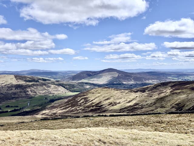
Meall Uaine — the green hill — is a 794m Marilyn in NO-square Atholl, perched above the Glen Brerachan road between Kirkmichael and Enochdhu. The summit looks south to Strathardle and north into the broad bowl of upper Glen Shee — a quiet, high outlier of the Mount Blair country.
Quick facts
- Height
- 794m/ 2605ft
- Prominence
- 147 m
- Grid ref
- NO 11061 67403
- Nearest city
- Perth· 44km
- Dogs
- Dogs on lead required near livestockDog-friendly guide ↗
Sub-Marilyn: 147m of drop — misses the 150m Marilyn cut by 3m. We keep it on the list as a near-miss.
Height and prominence cross-checked against the Database of British and Irish Hills (CC BY).
No GPX track yet
Walked this route? Share your track to help other walkers.
Standard route
heather moorland 60% · grass slopes 30% · rocky summit 10%
Start from the A924 north of Kirkmichael, parking near Enochdhu and following the estate track north over the watershed. A short pull on heather and short turf leads to the broad summit, a sloping bilberry shelf marked by a small cairn.
Terrain
Estate road for the in-walk, then well-burned heather giving way to bilberry and crowberry on the upper slopes. Dry underfoot — the granite floor of the area drains efficiently.
In winter
East-Highland snow lies dry and crisp on this side of the watershed. The summit gathers wind-loaded drifts off the north-west; spindrift over the gentle dome makes navigation tricky in stiff westerlies.
Best time of year
Getting there
- Glasgow3h 9m
- Edinburgh2h 16m
OS maps: OS Landranger 43, OS Explorer 052S, OS Explorer 387S
Mobile signal: Minimal. no EE bars on this remote Breadalbane hill; nearest coverage near Killin.
Current conditions
Daylight Today
- Sunrise
- 05:09
- Sunset
- 21:31
- Civil dawn
- 04:18
- Civil dusk
- 22:23
NOAA Solar Calculator · 30 July 2026
Around Meall Uaine on the SCOT network
Getting there, basing yourself, and what to do off the hill.
Getting there: Pitlochry station
Schiehallion, Ben Vrackie, Beinn a Ghlo, Edradour distillery
19km from the hill
tripscot.co.uk
On TripSCOTBase yourself in Pitlochry
Perthshire base — Schiehallion, Beinn a Ghlo, Ben Vrackie
19km from the hill
tripscot.co.uk
On TasteSCOTAfter the hill: Edradour
Pitlochry — until recently Scotland's smallest distillery; charming Perthshire setting
17km from the hill
tastescot.co.uk
Meall Uaine — common questions
- How difficult is Meall Uaine?
- Meall Uaine carries a 2/5 (moderate) grade on the OutdoorSCOT scale. Terrain: Estate road for the in-walk, then well-burned heather giving way to bilberry and crowberry on the upper slopes.
- How prominent is Meall Uaine?
- Meall Uaine has 147m of topographic prominence — the height of its summit above the highest col connecting it to higher ground. That leaves it 3m short of the 150m drop a Marilyn needs — DoBIH classes it a sub-Marilyn, a near-miss rather than a full Marilyn.
- When should I climb Meall Uaine?
- The standard good-weather months for Meall Uaine are April, May, June, September. Outside those months, expect winter conditions on the high ground — full mountain kit, navigation skills, and a check of the SAIS avalanche forecast for the relevant region.
- Can I bring my dog up Meall Uaine?
- On a lead only — the route crosses ground with livestock or nesting-bird interest.
- What's mobile reception like on Meall Uaine?
- Minimal. no EE bars on this remote Breadalbane hill; nearest coverage near Killin.
- Is Meall Uaine safe in winter?
- East-Highland snow lies dry and crisp on this side of the watershed. The summit gathers wind-loaded drifts off the north-west; spindrift over the gentle dome makes navigation tricky in stiff westerlies.
Get the OutdoorSCOT weekly
One email a week — new route, hill and bothy guides, seasonal conditions and the odd hard-won lesson. No spam, unsubscribe in one click.