Sub-Marilyn · Perthshire
Meall a' Choire Bhuidhe
Meall a' Choire Bhuidhe — the lump of the yellow corrie — is an 868m Marilyn in NO-square Atholl, set above the moorland north of Strath Tummel and west of Killiecrankie. The summit is a high outlier of the Beinn a' Ghlo range and looks south over the Tay valley to Schiehallion.
Gaelic: “rounded hill, of the, corrie” · Pronunciation: myowl uh chor-a bhuidhe
Quick facts
- Height
- 868m/ 2848ft
- Prominence
- 143 m
- Grid ref
- NO 06188 71032
- Nearest city
- Perth· 48km
- Dogs
- Dogs on lead required near livestockDog-friendly guide ↗
Sub-Marilyn: 143m of drop — misses the 150m Marilyn cut by 7m. We keep it on the list as a near-miss.
Height and prominence cross-checked against the Database of British and Irish Hills (CC BY).
No GPX track yet
Walked this route? Share your track to help other walkers.
Standard route
heather moorland 60% · grass slopes 30% · rocky summit 10%
A typical approach is from the small road end at Old Blair, taking the stalking path north past Loch Moraig and climbing west onto the hill's broad south flank. The summit cairn sits on a flattish plateau just south of the larger Beinn a' Ghlo Munro mass.
Terrain
Stalker path for the first few kilometres, then rough heather and bilberry over schist. The titular yellow corrie is north-facing and steep — best avoided on descent.
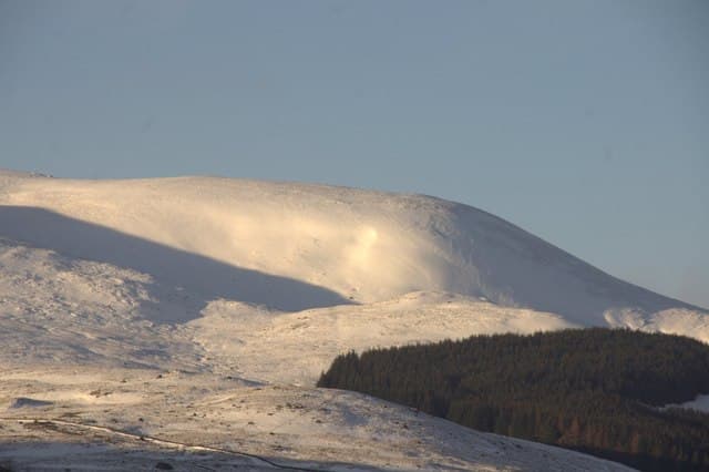
In winter
A genuine 868m mountain with a plateau that catches drifting snow. Cornices form on the north and east rims; the south approach stays much safer. Compass work is essential in cloud on the broad summit area.
Best time of year
Getting there
- Glasgow3h 5m
- Edinburgh2h 25m
OS maps: OS Landranger 43, OS Explorer 052N, OS Explorer 387N
Mobile signal: Poor. Remote Breadalbane glen; EE and Vodafone both blank. Killin is nearest coverage.
Current conditions
Daylight Today
- Sunrise
- 05:10
- Sunset
- 21:32
- Civil dawn
- 04:18
- Civil dusk
- 22:23
NOAA Solar Calculator · 30 July 2026
Around Meall a' Choire Bhuidhe on the SCOT network
Getting there, basing yourself, and what to do off the hill.
Getting there: Pitlochry station
Schiehallion, Ben Vrackie, Beinn a Ghlo, Edradour distillery
17km from the hill
tripscot.co.uk
On TripSCOTBase yourself in Pitlochry
Perthshire base — Schiehallion, Beinn a Ghlo, Ben Vrackie
17km from the hill
tripscot.co.uk
On TasteSCOTAfter the hill: Edradour
Pitlochry — until recently Scotland's smallest distillery; charming Perthshire setting
15km from the hill
tastescot.co.uk
Meall a' Choire Bhuidhe — common questions
- How difficult is Meall a' Choire Bhuidhe?
- Meall a' Choire Bhuidhe carries a 3/5 (moderately challenging) grade on the OutdoorSCOT scale. Underfoot: Stalker path for the first few kilometres, then rough heather and bilberry over schist.
- What is Meall a' Choire Bhuidhe's prominence?
- 143m of prominence. That's the vertical drop from the summit to the col that links Meall a' Choire Bhuidhe to the next higher ground. That leaves it 7m short of the 150m drop a Marilyn needs — DoBIH classes it a sub-Marilyn, a near-miss rather than a full Marilyn.
- When is the best time to climb Meall a' Choire Bhuidhe?
- April, May, June, September give the most reliable conditions on Meall a' Choire Bhuidhe. Beyond that window the high ground turns wintry: carry full mountain kit, be confident navigating, and check the SAIS avalanche forecast for the area.
- Is Meall a' Choire Bhuidhe dog-friendly?
- Yes, but dogs must be kept on a lead — there is livestock or ground-nesting bird interest on the route.
- Is there mobile signal on Meall a' Choire Bhuidhe?
- Poor. Remote Breadalbane glen; EE and Vodafone both blank. Killin is nearest coverage.
- Is Meall a' Choire Bhuidhe safe in winter?
- A genuine 868m mountain with a plateau that catches drifting snow. Cornices form on the north and east rims; the south approach stays much safer. Compass work is essential in cloud on the broad summit area.
Get the OutdoorSCOT weekly
One email a week — new route, hill and bothy guides, seasonal conditions and the odd hard-won lesson. No spam, unsubscribe in one click.