Marilyn · Fife & Perthshire
Hill of Persie
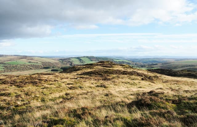
A grouse-moor 445m summit set between Blairgowrie and Glenshee, low enough for a short morning outing but with the prominence to deliver surprising views west to Schiehallion and north to the Glen Shee tops. The hill is part of a working sporting estate.
Quick facts
- Height
- 445.7m/ 1462ft
- Prominence
- 168 m
- Grid ref
- NO 12247 56049
- Nearest city
- Perth· 32km
- Dogs
- Dogs on lead required near livestockDog-friendly guide ↗
Height and prominence cross-checked against the Database of British and Irish Hills (CC BY).
No GPX track yet
Walked this route? Share your track to help other walkers.
Standard route
heather moorland 70% · grass slopes 20% · rocky summit 10%
From a layby on the minor road towards Bridge of Cally, an estate track climbs gently through managed heather strips before petering out onto open moor. Aim directly for the trig pillar; the round trip is about 5km and 1.5 to 2 hours.
Terrain
Firm muirburn-managed heather underfoot, with shooting butts dotted across the upper plateau. A single peaty depression on the eastern flank can be boggy in spring but is easily skirted.
In winter
Snow accumulation is variable on this fringe-of-the-Highlands hill — usually walkable in trail shoes between October and April. Avoid the area during the August-to-December grouse shoot.
Best time of year
Getting there
- Glasgow3h 0m
- Edinburgh2h 0m
OS maps: OS Landranger 53, OS Explorer 052S, OS Explorer 387S
Mobile signal: Moderate. EE sporadic up top; better toward Blairgowrie.
Current conditions
Daylight Today
- Sunrise
- 06:42
- Sunset
- 19:37
- Civil dawn
- 06:04
- Civil dusk
- 20:15
NOAA Solar Calculator · 14 September 2026
Around Hill of Persie on the SCOT network
Getting there, basing yourself, and what to do off the hill.
Getting there: Dunkeld & Birnam station
Birnam Hill, Hermitage walks, southern Perthshire gateway
16km from the hill
tripscot.co.uk
On TripSCOTBase yourself in Dunkeld
Southern Cairngorms gateway — Hermitage, Loch of the Lowes
16km from the hill
tripscot.co.uk
On TasteSCOTAfter the hill: Edradour
Pitlochry — until recently Scotland's smallest distillery; charming Perthshire setting
16km from the hill
tastescot.co.uk
Hill of Persie — common questions
- How difficult is Hill of Persie?
- Hill of Persie carries a 1/5 (easy) grade on the OutdoorSCOT scale. Terrain: Firm muirburn-managed heather underfoot, with shooting butts dotted across the upper plateau.
- How prominent is Hill of Persie?
- Hill of Persie has 168m of topographic prominence — the height of its summit above the highest col connecting it to higher ground. Marilyns are defined by that measure: at least 150m of drop on all sides.
- When should I climb Hill of Persie?
- The standard good-weather months for Hill of Persie are March, April, May, June, July, August, September, October. Outside those months, expect winter conditions on the high ground — full mountain kit, navigation skills, and a check of the SAIS avalanche forecast for the relevant region.
- Can I bring my dog up Hill of Persie?
- On a lead only — the route crosses ground with livestock or nesting-bird interest.
- What's mobile reception like on Hill of Persie?
- Moderate. EE sporadic up top; better toward Blairgowrie.
- Is Hill of Persie safe in winter?
- Snow accumulation is variable on this fringe-of-the-Highlands hill — usually walkable in trail shoes between October and April. Avoid the area during the August-to-December grouse shoot.
Get the OutdoorSCOT weekly
One email a week — new route, hill and bothy guides, seasonal conditions and the odd hard-won lesson. No spam, unsubscribe in one click.