Sub-Marilyn · Perthshire
Creag an t-Sithein
Creag an t-Sithein — the fairy crag — is a 634m Marilyn in NO-square Perthshire, set on the moorland between Strath Tummel and Strath Tay north of Aberfeldy. The summit looks south to the wooded ridge of Farragon and east toward the Tay falling away to Grandtully.
Quick facts
- Height
- 634.4m/ 2081ft
- Prominence
- 148 m
- Grid ref
- NO 03186 65823
- Nearest city
- Perth· 43km
- Dogs
- Dogs on lead required near livestockDog-friendly guide ↗
Sub-Marilyn: 148m of drop — misses the 150m Marilyn cut by 2m. We keep it on the list as a near-miss.
Height and prominence cross-checked against the Database of British and Irish Hills (CC BY).
No GPX track yet
Walked this route? Share your track to help other walkers.
Standard route
heather moorland 55% · rocky slopes 30% · grass slopes 15%
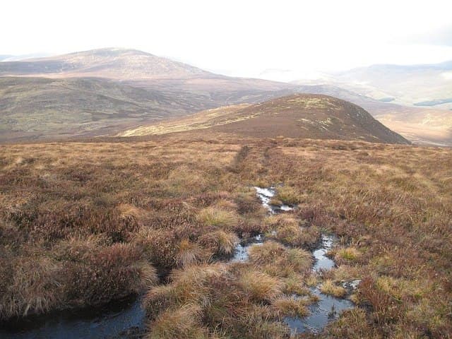
The usual start is from the minor road past Tullypowrie north of Strathtay, climbing the estate track to the upper sheilings before turning west onto open moor. The summit is a rocky knot in a sea of heather, marked by a small cairn perched on a slab of mica-schist.
Terrain
Estate track through birch and old pasture, then well-managed grouse moor on the upper slopes. The summit slabs are slippery when wet but otherwise the going is comfortable underfoot.
In winter
A 634m hill on the gentler east side of the watershed — snow comes and goes through winter but rarely stays long below 500m. Ice on the summit slabs is the standard hazard; spikes more useful than crampons.
Best time of year
Getting there
- Glasgow3h 55m
- Edinburgh2h 22m
OS maps: OS Landranger 43, OS Explorer 052S, OS Explorer 387S
Mobile signal: Expect little. coverage drops during the approach; remote Perthshire glen gives zero coverage.
Current conditions
Daylight Today
- Sunrise
- 05:10
- Sunset
- 21:32
- Civil dawn
- 04:19
- Civil dusk
- 22:23
NOAA Solar Calculator · 30 July 2026
Around Creag an t-Sithein on the SCOT network
Getting there, basing yourself, and what to do off the hill.
Getting there: Pitlochry station
Schiehallion, Ben Vrackie, Beinn a Ghlo, Edradour distillery
11km from the hill
tripscot.co.uk
On TripSCOTBase yourself in Pitlochry
Perthshire base — Schiehallion, Beinn a Ghlo, Ben Vrackie
11km from the hill
tripscot.co.uk
On TasteSCOTAfter the hill: Edradour
Pitlochry — until recently Scotland's smallest distillery; charming Perthshire setting
9km from the hill
tastescot.co.uk
Creag an t-Sithein — common questions
- How difficult is Creag an t-Sithein?
- Creag an t-Sithein carries a 2/5 (moderate) grade on the OutdoorSCOT scale. Terrain: Estate track through birch and old pasture, then well-managed grouse moor on the upper slopes.
- How prominent is Creag an t-Sithein?
- Creag an t-Sithein has 148m of topographic prominence — the height of its summit above the highest col connecting it to higher ground. That leaves it 2m short of the 150m drop a Marilyn needs — DoBIH classes it a sub-Marilyn, a near-miss rather than a full Marilyn.
- When should I climb Creag an t-Sithein?
- The standard good-weather months for Creag an t-Sithein are March, April, May, June, July, August, September, October. Outside those months, expect winter conditions on the high ground — full mountain kit, navigation skills, and a check of the SAIS avalanche forecast for the relevant region.
- Can I bring my dog up Creag an t-Sithein?
- On a lead only — the route crosses ground with livestock or nesting-bird interest.
- What's mobile reception like on Creag an t-Sithein?
- Expect little. coverage drops during the approach; remote Perthshire glen gives zero coverage.
- Is Creag an t-Sithein safe in winter?
- A 634m hill on the gentler east side of the watershed — snow comes and goes through winter but rarely stays long below 500m. Ice on the summit slabs is the standard hazard; spikes more useful than crampons.
Get the OutdoorSCOT weekly
One email a week — new route, hill and bothy guides, seasonal conditions and the odd hard-won lesson. No spam, unsubscribe in one click.