Marilyn · Perthshire
Meall Gainmheich
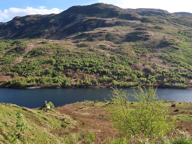
Meall Gainmheich — the sandy hill — is a 566m grassy dome on the Trossachs ridge north of Loch Katrine, at NN 509 095. It lies between Ben Venue and Stob a' Choin, and the name comes from the granite-sand crests near the summit. The view south takes in the entire length of Loch Katrine and across to Ben Lomond.
Quick facts
- Height
- 566m/ 1857ft
- Prominence
- 223 m
- Grid ref
- NN 50959 09512
- Nearest city
- Stirling· 33km
- Dogs
- Dogs on lead required near livestockDog-friendly guide ↗
Height and prominence cross-checked against the Database of British and Irish Hills (CC BY).
No GPX track yet
Walked this route? Share your track to help other walkers.
Standard route
heather moorland 65% · grass slopes 25% · sandy outcrops 10%
The usual approach is from Ledard Farm on the north shore of Loch Ard. Follow the Allt a' Choire Bhain path past the falls, then strike west off the main path onto the south-east ridge, climbing through bracken and heather to the open summit.
Terrain
Bracken and birch wood on the lower hill, opening to deep heather and sphagnum bog on the broad south-east ridge. The summit cap is sandy grass dotted with weather-bleached schist blocks — the source of the hill name.
In winter
A modest Trossachs top where wet snow rarely lasts more than days; the boggy plateau freezes into a useful firmer surface in cold weather. Visibility on the broad summit is the main concern — compass work is essential in cloud.
Best time of year
Getting there
- Glasgow1h 6m
- Edinburgh3h 15m
OS maps: OS Landranger 57, OS Explorer 046S, OS Explorer 365S
Mobile signal: Poor. Remote Glen Garry/Loch Quoich area; very limited coverage.
Current conditions
Daylight Today
- Sunrise
- 05:16
- Sunset
- 21:32
- Civil dawn
- 04:26
- Civil dusk
- 22:22
NOAA Solar Calculator · 30 July 2026
Around Meall Gainmheich on the SCOT network
Getting there, basing yourself, and what to do off the hill.
Getting there: Crianlarich station
Crianlarich Munros — Ben More, Stob Binnein, Ben Lui, Cruach Ardrain
20km from the hill
tripscot.co.uk
On TripSCOTBase yourself in Callander
Trossachs gateway — Ben Ledi, Stuc a Chroin, Rob Roy Way
12km from the hill
tripscot.co.uk
On TasteSCOTAfter the hill: Deanston
Doune — converted cotton mill; floral, honeyed Perthshire distillery
23km from the hill
tastescot.co.uk
Meall Gainmheich — common questions
- Is Meall Gainmheich a hard climb?
- Meall Gainmheich is rated 2/5 (moderate) on the OutdoorSCOT scale. Ground conditions: Bracken and birch wood on the lower hill, opening to deep heather and sphagnum bog on the broad south-east ridge.
- How much drop does Meall Gainmheich have?
- The drop is 223m: measured from the summit of Meall Gainmheich down to the saddle joining it to higher terrain. Passing the 150m-drop threshold on all sides is exactly what makes it a Marilyn.
- What's the best month to climb Meall Gainmheich?
- Aim for March, April, May, June, July, August, September, October on Meall Gainmheich. In the remaining months treat it as a winter hill — full kit, solid navigation, and a look at the relevant SAIS avalanche forecast before you go.
- Can dogs go up Meall Gainmheich?
- Dogs are fine on a lead. The route passes livestock or ground-nesting bird habitat, so keep them close throughout.
- Will I get phone signal on Meall Gainmheich?
- Poor. Remote Glen Garry/Loch Quoich area; very limited coverage.
- Is Meall Gainmheich safe in winter?
- A modest Trossachs top where wet snow rarely lasts more than days; the boggy plateau freezes into a useful firmer surface in cold weather. Visibility on the broad summit is the main concern — compass work is essential in cloud.
Get the OutdoorSCOT weekly
One email a week — new route, hill and bothy guides, seasonal conditions and the odd hard-won lesson. No spam, unsubscribe in one click.