Marilyn · Perthshire
Beinn an t-Sidhein
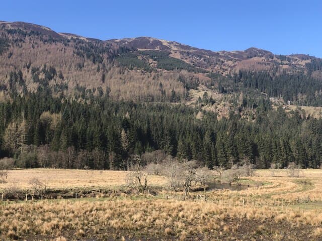
Beinn an t-Sidhein — the fairy hill — is the 572m guardian peak of Strathyre, rising directly above the village at NN 547 178. Tradition says the fairies of Loch Lubnaig lived on its summit. The hill's eastern flank drops steeply through Sitka spruce to the river; the Forestry Commission maintains a network of waymarked paths up its lower slopes.
Quick facts
- Height
- 572m/ 1877ft
- Prominence
- 287 m
- Grid ref
- NN 54699 17854
- Nearest city
- Stirling· 35km
- Dogs
- Dogs on lead required near livestockDog-friendly guide ↗
Height and prominence cross-checked against the Database of British and Irish Hills (CC BY).
No GPX track yet
Walked this route? Share your track to help other walkers.
Standard route
heather moorland 60% · grass slopes 30% · rocky summit 10%
Cross the footbridge over the Balvaig at Strathyre and follow the green waymarkers past the old croft of Laggan, climbing the forestry track to the upper deer fence. From there a clear path follows the south-east ridge through outcrops to the summit cairn.
Terrain
Sitka spruce plantation on the lower hill (often muddy on the forest road), then a clear stony ridge path on the open hill above the fence. A couple of short rocky steps on the summit ridge but no exposure.
In winter
Wet snow on the upper ridge in cold spells; rime ice on the deer fence is sometimes the only landmark in cloud. The forest road below freezes into ice slicks. Microspikes are useful from December through February.
Best time of year
Getting there
- Glasgow1h 14m
- Edinburgh3h 9m
OS maps: OS Landranger 57, OS Explorer 046N, OS Explorer 365N
Mobile signal: Poor. Remote Perthshire/Stirlingshire edge; limited coverage.
Current conditions
Daylight Today
- Sunrise
- 05:15
- Sunset
- 21:32
- Civil dawn
- 04:25
- Civil dusk
- 22:22
NOAA Solar Calculator · 30 July 2026
Around Beinn an t-Sidhein on the SCOT network
Getting there, basing yourself, and what to do off the hill.
Getting there: Crianlarich station
Crianlarich Munros — Ben More, Stob Binnein, Ben Lui, Cruach Ardrain
18km from the hill
tripscot.co.uk
On TripSCOTBase yourself in Callander
Trossachs gateway — Ben Ledi, Stuc a Chroin, Rob Roy Way
13km from the hill
tripscot.co.uk
On TasteSCOTAfter the hill: Deanston
Doune — converted cotton mill; floral, honeyed Perthshire distillery
25km from the hill
tastescot.co.uk
Beinn an t-Sidhein — common questions
- What difficulty is Beinn an t-Sidhein?
- On the OutdoorSCOT scale, Beinn an t-Sidhein comes in at 2/5 — moderate. Underfoot: Sitka spruce plantation on the lower hill (often muddy on the forest road), then a clear stony ridge path on the open hill above the fence.
- What is Beinn an t-Sidhein's prominence?
- 287m of prominence. That's the vertical drop from the summit to the col that links Beinn an t-Sidhein to the next higher ground. That drop is what qualifies it as a Marilyn — a hill with at least 150m of descent on every side.
- When is the best time to climb Beinn an t-Sidhein?
- March, April, May, June, July, August, September, October give the most reliable conditions on Beinn an t-Sidhein. Beyond that window the high ground turns wintry: carry full mountain kit, be confident navigating, and check the SAIS avalanche forecast for the area.
- Is Beinn an t-Sidhein dog-friendly?
- Yes, but dogs must be kept on a lead — there is livestock or ground-nesting bird interest on the route.
- Is there mobile signal on Beinn an t-Sidhein?
- Poor. Remote Perthshire/Stirlingshire edge; limited coverage.
- Is Beinn an t-Sidhein safe in winter?
- Wet snow on the upper ridge in cold spells; rime ice on the deer fence is sometimes the only landmark in cloud. The forest road below freezes into ice slicks. Microspikes are useful from December through February.
Get the OutdoorSCOT weekly
One email a week — new route, hill and bothy guides, seasonal conditions and the odd hard-won lesson. No spam, unsubscribe in one click.