Sub-Marilyn · Perthshire
Meall Cala
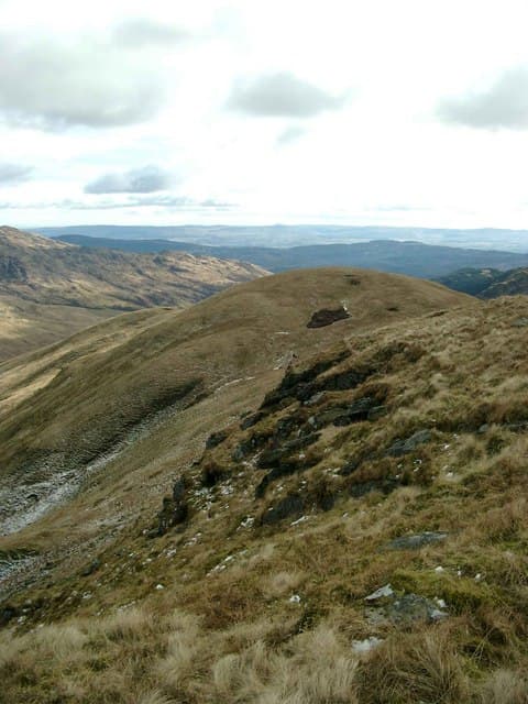
Meall Cala stands at 674m above the south shore of Loch Tay in the Glen Lochay foothills — NN 508 127. The hill takes its name from the lumpy outcrops at its top and forms a long heather ridge between the Tarmachan group and Glen Dochart. From the summit cairn the Ben Lawers range fills the northern sky and Loch Tay glints away east towards Killin.
Quick facts
- Height
- 674m/ 2211ft
- Prominence
- 149 m
- Grid ref
- NN 50831 12767
- Nearest city
- Stirling· 35km
- Dogs
- Dogs on lead required near livestockDog-friendly guide ↗
Sub-Marilyn: 149m of drop — misses the 150m Marilyn cut by 1m. We keep it on the list as a near-miss.
Height and prominence cross-checked against the Database of British and Irish Hills (CC BY).
No GPX track yet
Walked this route? Share your track to help other walkers.
Standard route
heather moorland 65% · grass slopes 25% · rocky summit 10%
Park beside the lochside layby east of Tarmachan track at NN 614 379 or use the Glen Lochay road. The shortest line climbs the rough flank from the unclassified road at NN 525 137 up the east shoulder over Creag a' Mhadaidh; allow a longer day for a circuit via the Tarmachan watershed.
Terrain
Deep heather and bog myrtle on the lower flanks giving way to wind-clipped grass and broken schist around the summit. There is no continuous path — expect heavy going for the first 200m of ascent.
In winter
At 674m the top regularly sits in cloud and accumulates snow drifts in the lee of the east shoulder. Treat as a serious hill day in winter: full kit, ice axe and a clear plan if cloud descends, as the summit ridge has few landmarks.
Best time of year
Getting there
- Glasgow1h 10m
- Edinburgh3h 16m
OS maps: OS Landranger 57, OS Explorer 046S, OS Explorer 365S
Mobile signal: Expect little. Remote north Perthshire; only patchy coverage here.
Current conditions
Daylight Today
- Sunrise
- 05:16
- Sunset
- 21:32
- Civil dawn
- 04:26
- Civil dusk
- 22:22
NOAA Solar Calculator · 30 July 2026
Around Meall Cala on the SCOT network
Getting there, basing yourself, and what to do off the hill.
Getting there: Crianlarich station
Crianlarich Munros — Ben More, Stob Binnein, Ben Lui, Cruach Ardrain
18km from the hill
tripscot.co.uk
On TripSCOTBase yourself in Callander
Trossachs gateway — Ben Ledi, Stuc a Chroin, Rob Roy Way
13km from the hill
tripscot.co.uk
On TasteSCOTAfter the hill: Deanston
Doune — converted cotton mill; floral, honeyed Perthshire distillery
25km from the hill
tastescot.co.uk
Meall Cala — common questions
- Is Meall Cala a hard climb?
- Meall Cala is rated 2/5 (moderate) on the OutdoorSCOT scale. Underfoot: Deep heather and bog myrtle on the lower flanks giving way to wind-clipped grass and broken schist around the summit.
- What is Meall Cala's prominence?
- 149m of prominence. That's the vertical drop from the summit to the col that links Meall Cala to the next higher ground. That leaves it 1m short of the 150m drop a Marilyn needs — DoBIH classes it a sub-Marilyn, a near-miss rather than a full Marilyn.
- When is the best time to climb Meall Cala?
- March, April, May, June, July, August, September, October give the most reliable conditions on Meall Cala. Beyond that window the high ground turns wintry: carry full mountain kit, be confident navigating, and check the SAIS avalanche forecast for the area.
- Is Meall Cala dog-friendly?
- Yes, but dogs must be kept on a lead — there is livestock or ground-nesting bird interest on the route.
- Is there mobile signal on Meall Cala?
- Expect little. Remote north Perthshire; only patchy coverage here.
- Is Meall Cala safe in winter?
- At 674m the top regularly sits in cloud and accumulates snow drifts in the lee of the east shoulder. Treat as a serious hill day in winter: full kit, ice axe and a clear plan if cloud descends, as the summit ridge has few landmarks.
Get the OutdoorSCOT weekly
One email a week — new route, hill and bothy guides, seasonal conditions and the odd hard-won lesson. No spam, unsubscribe in one click.