Marilyn · Perthshire
Beinn Dearg
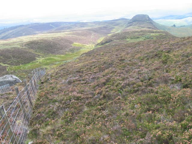
Beinn Dearg — the red hill — at 427m is a quiet heather summit in the Menteith Hills south-east of Loch Katrine, at NN 588 037. The hill takes its name from the red-tinged peat and bracken that flushes the slopes in autumn. From the top you look south across the Carse of Stirling and north into the broken Trossachs ridges.
Gaelic: “mountain, red” · Pronunciation: bine jerr-ak
Quick facts
- Height
- 427m/ 1401ft
- Prominence
- 212 m
- Grid ref
- NN 58881 03785
- Nearest city
- Stirling· 23km
- Dogs
- Dogs on lead required near livestockDog-friendly guide ↗
Height and prominence cross-checked against the Database of British and Irish Hills (CC BY).
No GPX track yet
Walked this route? Share your track to help other walkers.
Standard route
heather moorland 65% · grass slopes 25% · rocky summit 10%
Park at the small forestry lay-by on the A81 east of Loch Achray and follow the Menteith Hills track that links Aberfoyle and Callander, leaving the path on the high col south of Lochan Allt a' Chip Dhuibh to climb due east up open heather to the cairn.
Terrain
A clear forest track for most of the approach; the off-track section is short but on tussocky heather and minor peat hags. The summit area is firm grass with a small cairn on a low rocky knoll.
In winter
A low Menteith hill where snow is mostly thin and short-lived. Frozen peat hags make the off-track section easier in cold weather; ice on the forestry track and slumped lay-by mud are the principal nuisances.
Best time of year
Getting there
- Glasgow1h 53m
- Edinburgh3h 53m
OS maps: OS Landranger 57, OS Explorer 046S, OS Explorer 365S
Mobile signal: Poor. Remote Perthshire/Loch Lyon area; limited coverage.
Current conditions
Daylight Today
- Sunrise
- 05:16
- Sunset
- 21:31
- Civil dawn
- 04:26
- Civil dusk
- 22:21
NOAA Solar Calculator · 30 July 2026
Around Beinn Dearg on the SCOT network
Getting there, basing yourself, and what to do off the hill.
Getting there: Dunblane station
Stirling-area; Sheriffmuir; gateway north
19km from the hill
tripscot.co.uk
On TripSCOTBase yourself in Callander
Trossachs gateway — Ben Ledi, Stuc a Chroin, Rob Roy Way
6km from the hill
tripscot.co.uk
On TasteSCOTAfter the hill: Deanston
Doune — converted cotton mill; floral, honeyed Perthshire distillery
14km from the hill
tastescot.co.uk
Beinn Dearg — common questions
- What difficulty is Beinn Dearg?
- On the OutdoorSCOT scale, Beinn Dearg comes in at 1/5 — easy. Underfoot: A clear forest track for most of the approach; the off-track section is short but on tussocky heather and minor peat hags.
- What is Beinn Dearg's prominence?
- 212m of prominence. That's the vertical drop from the summit to the col that links Beinn Dearg to the next higher ground. That drop is what qualifies it as a Marilyn — a hill with at least 150m of descent on every side.
- When is the best time to climb Beinn Dearg?
- March, April, May, June, July, August, September, October give the most reliable conditions on Beinn Dearg. Beyond that window the high ground turns wintry: carry full mountain kit, be confident navigating, and check the SAIS avalanche forecast for the area.
- Is Beinn Dearg dog-friendly?
- Yes, but dogs must be kept on a lead — there is livestock or ground-nesting bird interest on the route.
- Is there mobile signal on Beinn Dearg?
- Poor. Remote Perthshire/Loch Lyon area; limited coverage.
- Is Beinn Dearg safe in winter?
- A low Menteith hill where snow is mostly thin and short-lived. Frozen peat hags make the off-track section easier in cold weather; ice on the forestry track and slumped lay-by mud are the principal nuisances.
Get the OutdoorSCOT weekly
One email a week — new route, hill and bothy guides, seasonal conditions and the odd hard-won lesson. No spam, unsubscribe in one click.