Sub-Marilyn · Central Highlands
Marg na Craige
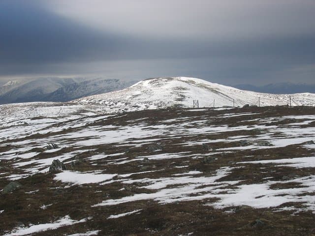
A remote 833m hill at the western end of the Monadhliath plateau, looking down on Loch Crunachdan and the Corrieyairack pass. The Gaelic Marg na Craige translates loosely as the table of the crag, referring to the flattish summit ringed by small cliffs on its southern face.
Quick facts
- Height
- 833.6m/ 2735ft
- Prominence
- 149 m
- Grid ref
- NN 62072 97321
- Nearest city
- Inverness· 48km
- Dogs
- Dogs on lead required near livestockDog-friendly guide ↗
Sub-Marilyn: 149m of drop — misses the 150m Marilyn cut by 1m. We keep it on the list as a near-miss.
Height and prominence cross-checked against the Database of British and Irish Hills (CC BY).
No GPX track yet
Walked this route? Share your track to help other walkers.
Standard route
heather moorland 65% · rocky slopes 25% · grass slopes 10%
A long approach from Sherrabeg in Glen Banchor, following a stalkers path up Allt Fionndrigh before striking up Mhargs broad eastern slopes. Allow 6 hours for the 18km return; navigation is the key skill required.
Terrain
Wet peat and tussock for the lower glen, drying to short turf and bouldery ground on the upper hill. The southern crags are loose and best avoided; descend the way you came up.
In winter
Significant winter mountain despite its modest elevation. Cornices form on the southern lip and the long approach demands genuine endurance in deep snow. Avalanche awareness essential on the south-facing crag rim.
This hill is in the Creag Meagaidh SAIS forecast area. Check SAIS forecasts in winter (December–April).
Best time of year
Getting there
- Glasgow3h 4m
- Edinburgh4h 59m
OS maps: OS Landranger 35, OS Explorer 056, OS Explorer 402
Mobile signal: Poor. Remote Strathspey/Badenoch; limited coverage.
Current conditions
Daylight Today
- Sunrise
- 05:11
- Sunset
- 21:36
- Civil dawn
- 04:19
- Civil dusk
- 22:28
NOAA Solar Calculator · 30 July 2026
Around Marg na Craige on the SCOT network
Getting there, basing yourself, and what to do off the hill.
Getting there: Dalwhinnie station
Highest mainline station; Drumochter Munros; Ben Alder approach
12km from the hill
tripscot.co.uk
On TripSCOTBase yourself in Aviemore
Cairngorms base — Strathspey valley, ski centre, train
32km from the hill
tripscot.co.uk
On TasteSCOTAfter the hill: Dalwhinnie
Dalwhinnie — Scotland's highest distillery on the Drumochter pass
12km from the hill
tastescot.co.uk
Marg na Craige — common questions
- Is Marg na Craige a hard climb?
- Marg na Craige is rated 3/5 (moderately challenging) on the OutdoorSCOT scale. Terrain: Wet peat and tussock for the lower glen, drying to short turf and bouldery ground on the upper hill.
- How prominent is Marg na Craige?
- Marg na Craige has 149m of topographic prominence — the height of its summit above the highest col connecting it to higher ground. That leaves it 1m short of the 150m drop a Marilyn needs — DoBIH classes it a sub-Marilyn, a near-miss rather than a full Marilyn.
- When should I climb Marg na Craige?
- The standard good-weather months for Marg na Craige are April, May, June, September. Outside those months, expect winter conditions on the high ground — full mountain kit, navigation skills, and a check of the SAIS avalanche forecast for the relevant region.
- Can I bring my dog up Marg na Craige?
- On a lead only — the route crosses ground with livestock or nesting-bird interest.
- What's mobile reception like on Marg na Craige?
- Poor. Remote Strathspey/Badenoch; limited coverage.
- Is Marg na Craige safe in winter?
- Significant winter mountain despite its modest elevation. Cornices form on the southern lip and the long approach demands genuine endurance in deep snow. Avalanche awareness essential on the south-facing crag rim.
Get the OutdoorSCOT weekly
One email a week — new route, hill and bothy guides, seasonal conditions and the odd hard-won lesson. No spam, unsubscribe in one click.