Sub-Marilyn · Central Highlands
Beinn Eilde
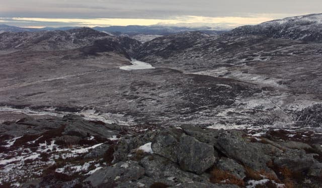
Beinn Eilde — the hill of the hinds — is a 674m Marilyn in NN-square Badenoch, set above the north end of Loch Ericht east of Dalwhinnie. The summit looks west across the long loch to Ben Alder and east into the Drumochter Munros, with the A9 humming faintly far below.
Quick facts
- Height
- 674m/ 2211ft
- Prominence
- 147 m
- Grid ref
- NN 56356 85031
- Nearest city
- Fort William· 47km
- Dogs
- Dogs on lead required near livestockDog-friendly guide ↗
Sub-Marilyn: 147m of drop — misses the 150m Marilyn cut by 3m. We keep it on the list as a near-miss.
Height and prominence cross-checked against the Database of British and Irish Hills (CC BY).
No GPX track yet
Walked this route? Share your track to help other walkers.
Standard route
heather moorland 65% · grass slopes 25% · rocky summit 10%
The standard line is from Dalwhinnie via the Loch Ericht estate road, leaving the track after a few kilometres and climbing east onto the broad heather flank. The summit is a low rise on a peaty plateau marked by a small cairn — easy walking once altitude is gained.
Terrain
Grouse-shot heather and well-burned strips on the lower slope, with bilberry, crowberry and peat hags above. The plateau is firm in dry weather but the hags hold water indefinitely.
In winter
Central Highland snow rather than maritime — drier, deeper and prone to forming wind-sculpted dunes on the plateau. The featureless top is a serious navigation exercise in cloud; bearings off the cairn fan out across a flat kilometre.
This hill is in the Creag Meagaidh SAIS forecast area. Check SAIS forecasts in winter (December–April).
Best time of year
Getting there
- Glasgow3h 47m
- Edinburgh4h 57m
OS maps: OS Landranger 42, OS Explorer 050, OS Explorer 393
Mobile signal: Poor. Remote Loch Ericht area; limited coverage.
Current conditions
Daylight Today
- Sunrise
- 05:12
- Sunset
- 21:36
- Civil dawn
- 04:21
- Civil dusk
- 22:27
NOAA Solar Calculator · 30 July 2026
Around Beinn Eilde on the SCOT network
Getting there, basing yourself, and what to do off the hill.
Beinn Eilde — common questions
- What difficulty is Beinn Eilde?
- On the OutdoorSCOT scale, Beinn Eilde comes in at 2/5 — moderate. Underfoot: Grouse-shot heather and well-burned strips on the lower slope, with bilberry, crowberry and peat hags above.
- What is Beinn Eilde's prominence?
- 147m of prominence. That's the vertical drop from the summit to the col that links Beinn Eilde to the next higher ground. That leaves it 3m short of the 150m drop a Marilyn needs — DoBIH classes it a sub-Marilyn, a near-miss rather than a full Marilyn.
- When is the best time to climb Beinn Eilde?
- March, April, May, June, July, August, September, October give the most reliable conditions on Beinn Eilde. Beyond that window the high ground turns wintry: carry full mountain kit, be confident navigating, and check the SAIS avalanche forecast for the area.
- Is Beinn Eilde dog-friendly?
- Yes, but dogs must be kept on a lead — there is livestock or ground-nesting bird interest on the route.
- Is there mobile signal on Beinn Eilde?
- Poor. Remote Loch Ericht area; limited coverage.
- Is Beinn Eilde safe in winter?
- Central Highland snow rather than maritime — drier, deeper and prone to forming wind-sculpted dunes on the plateau. The featureless top is a serious navigation exercise in cloud; bearings off the cairn fan out across a flat kilometre.
Get the OutdoorSCOT weekly
One email a week — new route, hill and bothy guides, seasonal conditions and the odd hard-won lesson. No spam, unsubscribe in one click.