Marilyn · Central Highlands
Creag a' Chliabhain
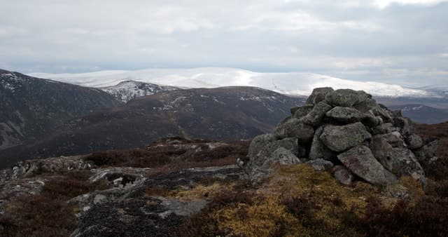
Creag a Chliabhain — the crag of the wicker creel — is a 519m heather summit in the Stratherrick uplands above the head of Loch Mhor. It is one of a cluster of broad Monadhliath outliers that fill the country between Whitebridge and Garrogie Lodge.
Quick facts
- Height
- 519m/ 1703ft
- Prominence
- 208 m
- Grid ref
- NH 57588 20570
- Nearest city
- Inverness· 26km
- Dogs
- Dogs on lead required near livestockDog-friendly guide ↗
Height and prominence cross-checked against the Database of British and Irish Hills (CC BY).
No GPX track yet
Walked this route? Share your track to help other walkers.
Standard route
heather moorland 60% · rocky slopes 25% · grass slopes 15%
A short route from the B862 near Loch Mhor or from the Garrogie estate track to the south. Either way the walking is mostly across rough heather pasture with a scattering of small lochans; the cairn marks a flat top rather than a sharp peak. Three hours or so out and back.
Terrain
Tussocky heather and bog-grass across an undulating plateau, with a few short outcrops of schist near the named crag. Drainage is poor where peat overlies the bedrock, so the ground squelches well into summer.
In winter
A modest 519m summit east of the main watershed. Snow lies in patches rather than blankets and the route is usually walkable through winter. Watch for thinly iced peat hags hidden under a dusting; an axe is rarely needed.
This hill is in the Creag Meagaidh SAIS forecast area. Check SAIS forecasts in winter (December–April).
Best time of year
Getting there
- Glasgow4h 37m
- Edinburgh5h 32m
OS maps: OS Landranger 26, OS Landranger 35, OS Explorer 417
Mobile signal: Patchy. EE and Vodafone come and go; signal returns reliably back at the B862.
Current conditions
Daylight Today
- Sunrise
- 05:10
- Sunset
- 21:37
- Civil dawn
- 04:18
- Civil dusk
- 22:30
NOAA Solar Calculator · 30 July 2026
Around Creag a' Chliabhain on the SCOT network
Getting there, basing yourself, and what to do off the hill.
Getting there: Inverness station
Highland capital — Cairngorms east side, Affric, Far North via bus/car
27km from the hill
tripscot.co.uk
On TripSCOTBase yourself in Inverness
Highland capital — gateway to Cairngorms, Affric, Far North
26km from the hill
tripscot.co.uk
On TasteSCOTAfter the hill: Tomatin
Tomatin — large Highland distillery just off the A9, south of Inverness
23km from the hill
tastescot.co.uk
Creag a' Chliabhain — common questions
- What difficulty is Creag a' Chliabhain?
- On the OutdoorSCOT scale, Creag a' Chliabhain comes in at 2/5 — moderate. Underfoot: Tussocky heather and bog-grass across an undulating plateau, with a few short outcrops of schist near the named crag.
- What is Creag a' Chliabhain's prominence?
- 208m of prominence. That's the vertical drop from the summit to the col that links Creag a' Chliabhain to the next higher ground. That drop is what qualifies it as a Marilyn — a hill with at least 150m of descent on every side.
- When is the best time to climb Creag a' Chliabhain?
- March, April, May, June, July, August, September, October give the most reliable conditions on Creag a' Chliabhain. Beyond that window the high ground turns wintry: carry full mountain kit, be confident navigating, and check the SAIS avalanche forecast for the area.
- Is Creag a' Chliabhain dog-friendly?
- Yes, but dogs must be kept on a lead — there is livestock or ground-nesting bird interest on the route.
- Is there mobile signal on Creag a' Chliabhain?
- Patchy. EE and Vodafone come and go; signal returns reliably back at the B862.
- Is Creag a' Chliabhain safe in winter?
- A modest 519m summit east of the main watershed. Snow lies in patches rather than blankets and the route is usually walkable through winter. Watch for thinly iced peat hags hidden under a dusting; an axe is rarely needed.
Get the OutdoorSCOT weekly
One email a week — new route, hill and bothy guides, seasonal conditions and the odd hard-won lesson. No spam, unsubscribe in one click.