Marilyn · Central Highlands
Creag nan Clag
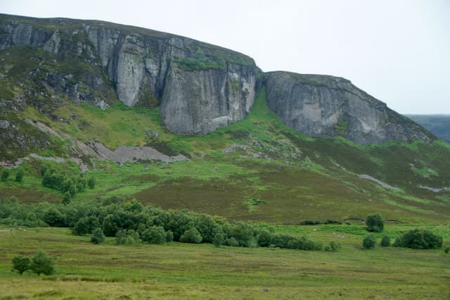
Creag nan Clag — the crag of the bells, an old reference to the parish church below — stands at 407m on the northern lip of the Monadhliath above Farr and Inverarnie. Despite the modest height it is a real summit with a panoramic outlook over the Beauly Firth to the Black Isle.
Quick facts
- Height
- 407m/ 1335ft
- Prominence
- 168 m
- Grid ref
- NH 59754 28342
- Nearest city
- Inverness· 18km
- Dogs
- Dogs on lead required near livestockDog-friendly guide ↗
Height and prominence cross-checked against the Database of British and Irish Hills (CC BY).
No GPX track yet
Walked this route? Share your track to help other walkers.
Standard route
heather moorland 55% · rocky slopes 30% · grass slopes 15%
A short pull up from the minor road past Farr, taking forestry tracks and then heather to the top. Easy underfoot once the plantation is cleared. Allow 2 hours including time on the airy summit.
Terrain
Forestry plantation low down, then a short heathery slope to a small crag. The summit ground is dry schist with crowberry and bilberry mat.
In winter
A low hill close to Inverness with no significant snow problems most years. Frozen forestry tracks and a few icy step-ups at the rocky brow are the only issues; spikes useful but axe unnecessary.
This hill is in the Creag Meagaidh SAIS forecast area. Check SAIS forecasts in winter (December–April).
Best time of year
Getting there
- Glasgow4h 47m
- Edinburgh5h 37m
OS maps: OS Landranger 26, OS Landranger 35, OS Explorer 417
Mobile signal: Reasonable. Good signal on the summit, with the Beauly Firth transmitters in line of sight.
Current conditions
Daylight Today
- Sunrise
- 05:10
- Sunset
- 21:38
- Civil dawn
- 04:17
- Civil dusk
- 22:31
NOAA Solar Calculator · 30 July 2026
Around Creag nan Clag on the SCOT network
Getting there, basing yourself, and what to do off the hill.
Getting there: Inverness station
Highland capital — Cairngorms east side, Affric, Far North via bus/car
18km from the hill
tripscot.co.uk
On TripSCOTBase yourself in Inverness
Highland capital — gateway to Cairngorms, Affric, Far North
18km from the hill
tripscot.co.uk
On TasteSCOTAfter the hill: Tomatin
Tomatin — large Highland distillery just off the A9, south of Inverness
19km from the hill
tastescot.co.uk
Creag nan Clag — common questions
- What difficulty is Creag nan Clag?
- On the OutdoorSCOT scale, Creag nan Clag comes in at 1/5 — easy. Underfoot: Forestry plantation low down, then a short heathery slope to a small crag.
- What is Creag nan Clag's prominence?
- 168m of prominence. That's the vertical drop from the summit to the col that links Creag nan Clag to the next higher ground. That drop is what qualifies it as a Marilyn — a hill with at least 150m of descent on every side.
- When is the best time to climb Creag nan Clag?
- March, April, May, June, July, August, September, October give the most reliable conditions on Creag nan Clag. Beyond that window the high ground turns wintry: carry full mountain kit, be confident navigating, and check the SAIS avalanche forecast for the area.
- Is Creag nan Clag dog-friendly?
- Yes, but dogs must be kept on a lead — there is livestock or ground-nesting bird interest on the route.
- Is there mobile signal on Creag nan Clag?
- Reasonable. Good signal on the summit, with the Beauly Firth transmitters in line of sight.
- Is Creag nan Clag safe in winter?
- A low hill close to Inverness with no significant snow problems most years. Frozen forestry tracks and a few icy step-ups at the rocky brow are the only issues; spikes useful but axe unnecessary.
Get the OutdoorSCOT weekly
One email a week — new route, hill and bothy guides, seasonal conditions and the odd hard-won lesson. No spam, unsubscribe in one click.