Marilyn · Argyll & Bute
Creachan Mor
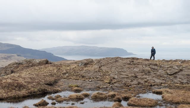
Creachan Mor stands 331m on the Ross of Mull granite, the high point of the peninsula's rolling moor. Unlike the basalt north of the island, this is pink granite country — pink boulders, pale grasses, and a long western horizon out to Iona and the Atlantic.
Gaelic: “big” · Pronunciation: creachan more
Quick facts
- Height
- 331m/ 1086ft
- Prominence
- 165 m
- Grid ref
- NM 49620 19565
- Nearest city
- Oban· 38km
- Dogs
- Dogs on lead required near livestockDog-friendly guide ↗
Height and prominence cross-checked against the Database of British and Irish Hills (CC BY).
No GPX track yet
Walked this route? Share your track to help other walkers.
Standard route
heather and bog 65% · grass slopes 25% · rocky summit 10%
Park near the head of Loch Beg on the A849 and follow the verge before striking south-west across the moor to the summit. There is no path and the moorland is rough, but the climb is short. Allow 3 hours return.
Terrain
Lumpy granite moor with peaty hollows between knolls. The going is uneven, with frequent small boulders concealed by heather — pick lines along the drier ridges where possible.
In winter
Open to weather from the Atlantic with nothing in the way to break the wind. Snow rarely amounts to more than a dusting but exposure is the real winter consideration here.
Best time of year
Getting there
- Glasgow5h 47m
- Edinburgh7h 27m
Ferry access
Oban → Craignure
- Crossing time45 min
- Summer sailingsUp to 8 sailings daily (Apr–Oct)
- Winter sailings4–5 sailings daily (Nov–Mar)
- Book ahead7 days
- Last ferry backCheck CalMac timetable — sailings run until ~21:00 in peak summer
Foot passengers can usually turn up without booking. Book vehicle spaces in advance. The Lochaline → Fishnish crossing (15 min) is shorter but serves east Mull only.
Book on CalMac ↗OS maps: OS Landranger 48, OS Explorer 373
Mobile signal: Poor. Little reliable signal; EE fails away from Craignure and Tobermory.
Current conditions
Daylight Today
- Sunrise
- 05:22
- Sunset
- 21:39
- Civil dawn
- 04:32
- Civil dusk
- 22:29
NOAA Solar Calculator · 30 July 2026
Around Creachan Mor on the SCOT network
Getting there, basing yourself, and what to do off the hill.
Creachan Mor — common questions
- How difficult is Creachan Mor?
- Creachan Mor carries a 1/5 (easy) grade on the OutdoorSCOT scale. Ground conditions: Lumpy granite moor with peaty hollows between knolls.
- How much drop does Creachan Mor have?
- The drop is 165m: measured from the summit of Creachan Mor down to the saddle joining it to higher terrain. Passing the 150m-drop threshold on all sides is exactly what makes it a Marilyn.
- What's the best month to climb Creachan Mor?
- Aim for March, April, May, June, July, August, September, October on Creachan Mor. In the remaining months treat it as a winter hill — full kit, solid navigation, and a look at the relevant SAIS avalanche forecast before you go.
- Can dogs go up Creachan Mor?
- Dogs are fine on a lead. The route passes livestock or ground-nesting bird habitat, so keep them close throughout.
- Will I get phone signal on Creachan Mor?
- Poor. Little reliable signal; EE fails away from Craignure and Tobermory.
- How do I get the ferry to Creachan Mor?
- Oban → Craignure. Up to 8 sailings daily (Apr–Oct) in summer; 4–5 sailings daily (Nov–Mar) in winter. Book at least 7 days ahead. Foot passengers can usually turn up without booking. Book vehicle spaces in advance. The Lochaline → Fishnish crossing (15 min) is shorter but serves east Mull only.
- Is Creachan Mor safe in winter?
- Open to weather from the Atlantic with nothing in the way to break the wind. Snow rarely amounts to more than a dusting but exposure is the real winter consideration here.
Get the OutdoorSCOT weekly
One email a week — new route, hill and bothy guides, seasonal conditions and the odd hard-won lesson. No spam, unsubscribe in one click.