Marilyn · Argyll & Bute
Beinn na Sreine
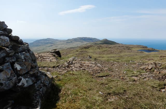
Beinn na Sreine — the Hill of the Bridle — is a 521m summit on Mull's wild Ardmeanach peninsula, set back from the cliffs of the Wilderness. It is a quietly worthwhile top, well placed for views down Loch Scridain and across to the Treshnish Isles.
Quick facts
- Height
- 521m/ 1709ft
- Prominence
- 376 m
- Grid ref
- NM 45644 30396
- Nearest city
- Oban· 40km
- Dogs
- Dogs on lead required near livestockDog-friendly guide ↗
Height and prominence cross-checked against the Database of British and Irish Hills (CC BY).
No GPX track yet
Walked this route? Share your track to help other walkers.
Standard route
heather and bog 60% · grass and deer sedge 25% · rocky summit 15%
Drive the single-track road to Tiroran on Loch Scridain and walk in north along the estate track before turning up onto open hillside. There is no path on the climb, just sheep-tracks angling between basalt benches. Allow 4 hours for the round trip.
Terrain
Heather banks and damp grass on the approach, with terraced basalt benches higher up. The benches are easily linked in good visibility but bewildering in mist.
In winter
Snow is uncommon at this altitude but the Ardmeanach peninsula is famously wet. Expect saturated ground from October until well into spring and consider gaiters at any time of year.
Best time of year
Getting there
- Glasgow5h 2m
- Edinburgh8h 41m
Ferry access
Oban → Craignure
- Crossing time45 min
- Summer sailingsUp to 8 sailings daily (Apr–Oct)
- Winter sailings4–5 sailings daily (Nov–Mar)
- Book ahead7 days
- Last ferry backCheck CalMac timetable — sailings run until ~21:00 in peak summer
Foot passengers can usually turn up without booking. Book vehicle spaces in advance. The Lochaline → Fishnish crossing (15 min) is shorter but serves east Mull only.
Book on CalMac ↗OS maps: OS Landranger 48, OS Explorer 373, OS Explorer 375W
Mobile signal: Expect little. EE missing; first coverage near Craighouse pier.
Current conditions
Daylight Today
- Sunrise
- 05:22
- Sunset
- 21:40
- Civil dawn
- 04:32
- Civil dusk
- 22:30
NOAA Solar Calculator · 30 July 2026
Around Beinn na Sreine on the SCOT network
Getting there, basing yourself, and what to do off the hill.
Getting there: Oban station
Argyll ferry hub; Mull, Lismore, Coll, Tiree, Barra connections
40km from the hill
tripscot.co.uk
On TripSCOTBase yourself in Tobermory
Mull base — Ben More, Treshnish, ferry to Iona
25km from the hill
tripscot.co.uk
On TasteSCOTAfter the hill: Tobermory
Mull — colourful harbour-front distillery making both unpeated and peated (Ledaig) whisky
25km from the hill
tastescot.co.uk
Beinn na Sreine — common questions
- How hard is Beinn na Sreine?
- We grade Beinn na Sreine at 2/5, which puts it in moderate territory. Terrain: Heather banks and damp grass on the approach, with terraced basalt benches higher up.
- How prominent is Beinn na Sreine?
- Beinn na Sreine has 376m of topographic prominence — the height of its summit above the highest col connecting it to higher ground. Marilyns are defined by that measure: at least 150m of drop on all sides.
- When should I climb Beinn na Sreine?
- The standard good-weather months for Beinn na Sreine are March, April, May, June, July, August, September, October. Outside those months, expect winter conditions on the high ground — full mountain kit, navigation skills, and a check of the SAIS avalanche forecast for the relevant region.
- Can I bring my dog up Beinn na Sreine?
- On a lead only — the route crosses ground with livestock or nesting-bird interest.
- What's mobile reception like on Beinn na Sreine?
- Expect little. EE missing; first coverage near Craighouse pier.
- How do I get the ferry to Beinn na Sreine?
- Oban → Craignure. Up to 8 sailings daily (Apr–Oct) in summer; 4–5 sailings daily (Nov–Mar) in winter. Book at least 7 days ahead. Foot passengers can usually turn up without booking. Book vehicle spaces in advance. The Lochaline → Fishnish crossing (15 min) is shorter but serves east Mull only.
- Is Beinn na Sreine safe in winter?
- Snow is uncommon at this altitude but the Ardmeanach peninsula is famously wet. Expect saturated ground from October until well into spring and consider gaiters at any time of year.
Get the OutdoorSCOT weekly
One email a week — new route, hill and bothy guides, seasonal conditions and the odd hard-won lesson. No spam, unsubscribe in one click.