Sub-Marilyn · Perthshire
Carn an Fhidhleir Lorgaidh
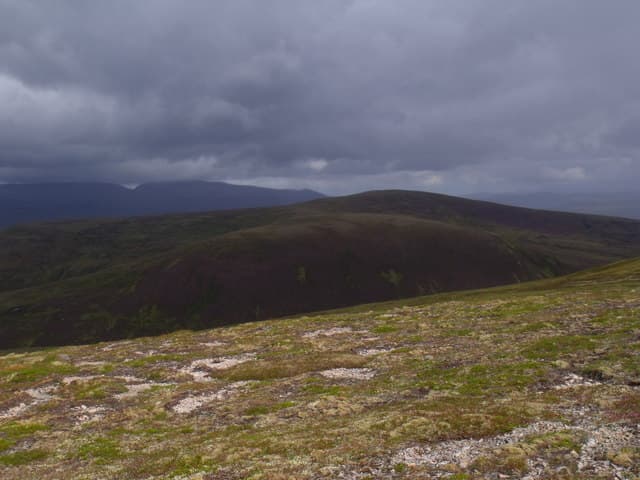
Carn an Fhidhleir Lorgaidh — the fiddler's cairn of Lorgaidh — is an 848m Marilyn in NN-square Atholl, deep in the remote Gaick pass between Glen Tromie and Glen Tilt. The summit is one of the most committing Marilyns in the central Highlands, with the empty plateaux of Tarf and Bynack stretching away in every direction.
Quick facts
- Height
- 848.6m/ 2784ft
- Prominence
- 142 m
- Grid ref
- NN 85624 87477
- Nearest city
- Inverness· 61km
- Dogs
- Dogs on lead required near livestockDog-friendly guide ↗
Sub-Marilyn: 142m of drop — misses the 150m Marilyn cut by 8m. We keep it on the list as a near-miss.
Height and prominence cross-checked against the Database of British and Irish Hills (CC BY).
No GPX track yet
Walked this route? Share your track to help other walkers.
Standard route
heather moorland 65% · grass slopes 25% · rocky summit 10%
The standard route uses the locked estate road south from Tromie Bridge into the Gaick, with bicycle giving the only sensible chance of a day return. From the watershed near Loch an Duin a long pathless climb on heather and stone leads up the south flank to the summit cairn.
Terrain
Tarmac then estate road for the in-walk, with peat hags and boulder fields on the upper hill. The summit ridge is fractured Cairngorm-style granite — the cairn sits on top of a small rise above bilberry shelves.
In winter
A genuinely committing winter hill — long in-walk by bicycle, then full snow conditions on the upper plateau. Avalanche-prone slopes flank both sides of the south ridge after wind-loading. Plan an alternative bothy night in case of weather.
Best time of year
Getting there
- Glasgow3h 0m
- Edinburgh3h 10m
OS maps: OS Landranger 43, OS Explorer 051E, OS Explorer 057S, OS Explorer 394E, OS Explorer 403S
Mobile signal: Poor. Remote Cairngorms edge; limited coverage.
Current conditions
Daylight Today
- Sunrise
- 05:10
- Sunset
- 21:34
- Civil dawn
- 04:18
- Civil dusk
- 22:26
NOAA Solar Calculator · 30 July 2026
Around Carn an Fhidhleir Lorgaidh on the SCOT network
Getting there, basing yourself, and what to do off the hill.
Getting there: Kingussie station
Cairngorms south side; Glen Feshie; Insh Marshes; Monadhliath access
17km from the hill
tripscot.co.uk
On TripSCOTBase yourself in Aviemore
Cairngorms base — Strathspey valley, ski centre, train
26km from the hill
tripscot.co.uk
On TasteSCOTAfter the hill: Dalwhinnie
Dalwhinnie — Scotland's highest distillery on the Drumochter pass
22km from the hill
tastescot.co.uk
Carn an Fhidhleir Lorgaidh — common questions
- How hard is Carn an Fhidhleir Lorgaidh?
- We grade Carn an Fhidhleir Lorgaidh at 3/5, which puts it in moderately challenging territory. Ground conditions: Tarmac then estate road for the in-walk, with peat hags and boulder fields on the upper hill.
- How much drop does Carn an Fhidhleir Lorgaidh have?
- The drop is 142m: measured from the summit of Carn an Fhidhleir Lorgaidh down to the saddle joining it to higher terrain. That leaves it 8m short of the 150m drop a Marilyn needs — DoBIH classes it a sub-Marilyn, a near-miss rather than a full Marilyn.
- What's the best month to climb Carn an Fhidhleir Lorgaidh?
- Aim for April, May, June, September on Carn an Fhidhleir Lorgaidh. In the remaining months treat it as a winter hill — full kit, solid navigation, and a look at the relevant SAIS avalanche forecast before you go.
- Can dogs go up Carn an Fhidhleir Lorgaidh?
- Dogs are fine on a lead. The route passes livestock or ground-nesting bird habitat, so keep them close throughout.
- Will I get phone signal on Carn an Fhidhleir Lorgaidh?
- Poor. Remote Cairngorms edge; limited coverage.
- Is Carn an Fhidhleir Lorgaidh safe in winter?
- A genuinely committing winter hill — long in-walk by bicycle, then full snow conditions on the upper plateau. Avalanche-prone slopes flank both sides of the south ridge after wind-loading. Plan an alternative bothy night in case of weather.
Get the OutdoorSCOT weekly
One email a week — new route, hill and bothy guides, seasonal conditions and the odd hard-won lesson. No spam, unsubscribe in one click.