Marilyn · Glen Coe & Lochaber
Ben Hiant
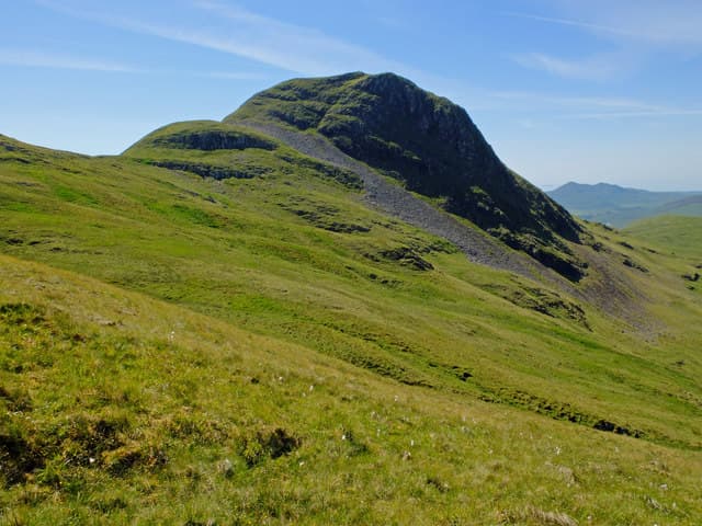
Ben Hiant — the Holy Mountain — is the most striking hill on Ardnamurchan, rising in a shapely double-headed cone above the Sound of Mull. Although only 528m, it is the eroded core of a Tertiary volcano, and the ascent picks its way through dykes and lava cliffs. The summit view is one of the most expansive in the western Highlands, taking in Mull, Coll, Tiree, Rum and Eigg.
Quick facts
- Height
- 528m/ 1732ft
- Prominence
- 463 m
- Grid ref
- NM 53769 63255
- Nearest city
- Oban· 46km
- Dogs
- Dogs on lead required near livestockDog-friendly guide ↗
Height and prominence cross-checked against the Database of British and Irish Hills (CC BY).
No GPX track yet
Walked this route? Share your track to help other walkers.
Standard route
heather and bog 50% · igneous rock 35% · grass slopes 15%
Start from the small layby at MacLean's Nose on the B8007 and follow the obvious grassy ramp eastwards onto the broad south ridge. A faint path threads up between basalt outcrops to the trig point. Around three hours up and down at a steady pace.
Terrain
A mix of cropped turf, exposed slabs of dark basalt and occasional volcanic scree. The path is intermittent but route-finding is easy in clear weather. Grass can be greasy after rain on the steeper rock steps.
In winter
Light snow cover is possible but rarely lasts. The greater hazard is wind — Ben Hiant's isolated profile catches Atlantic gales head on, and wet grass on the volcanic ramps becomes treacherous when frozen.
This hill is in the Glen Coe SAIS forecast area. Check SAIS forecasts in winter (December–April).
Best time of year
Getting there
- Glasgow5h 4m
- Edinburgh8h 35m
OS maps: OS Landranger 47, OS Explorer 390W
Mobile signal: Poor. Remote Ardnamurchan tip; limited coverage.
Current conditions
Daylight Today
- Sunrise
- 05:20
- Sunset
- 21:41
- Civil dawn
- 04:29
- Civil dusk
- 22:32
NOAA Solar Calculator · 30 July 2026
Around Ben Hiant on the SCOT network
Getting there, basing yourself, and what to do off the hill.
Getting there: Morar station
Silver Sands, Knoydart approach, Loch Morar
32km from the hill
tripscot.co.uk
On TripSCOTBase yourself in Tobermory
Mull base — Ben More, Treshnish, ferry to Iona
8km from the hill
tripscot.co.uk
On TasteSCOTAfter the hill: Tobermory
Mull — colourful harbour-front distillery making both unpeated and peated (Ledaig) whisky
8km from the hill
tastescot.co.uk
Ben Hiant — common questions
- How difficult is Ben Hiant?
- Ben Hiant carries a 2/5 (moderate) grade on the OutdoorSCOT scale. Ground conditions: A mix of cropped turf, exposed slabs of dark basalt and occasional volcanic scree.
- How much drop does Ben Hiant have?
- The drop is 463m: measured from the summit of Ben Hiant down to the saddle joining it to higher terrain. Passing the 150m-drop threshold on all sides is exactly what makes it a Marilyn.
- What's the best month to climb Ben Hiant?
- Aim for March, April, May, June, July, August, September, October on Ben Hiant. In the remaining months treat it as a winter hill — full kit, solid navigation, and a look at the relevant SAIS avalanche forecast before you go.
- Can dogs go up Ben Hiant?
- Dogs are fine on a lead. The route passes livestock or ground-nesting bird habitat, so keep them close throughout.
- Will I get phone signal on Ben Hiant?
- Poor. Remote Ardnamurchan tip; limited coverage.
- Is Ben Hiant safe in winter?
- Light snow cover is possible but rarely lasts. The greater hazard is wind — Ben Hiant's isolated profile catches Atlantic gales head on, and wet grass on the volcanic ramps becomes treacherous when frozen.
Get the OutdoorSCOT weekly
One email a week — new route, hill and bothy guides, seasonal conditions and the odd hard-won lesson. No spam, unsubscribe in one click.