Marilyn · Glen Coe & Lochaber
Beinn na Seilg
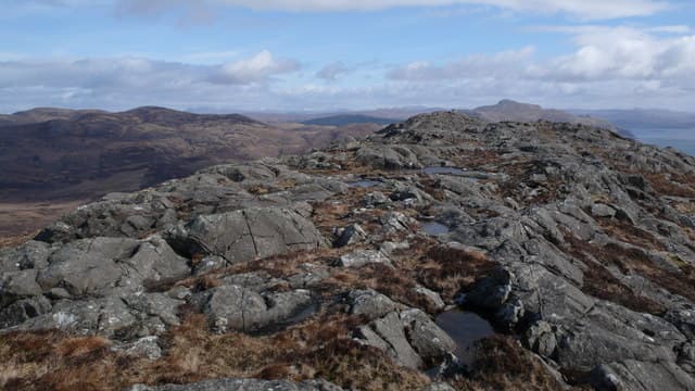
Beinn na Seilg — the Hunting Hill — is the highest point of the far western tip of Ardnamurchan, only 344m but commanding a panorama that takes in the entire Inner Hebrides on a clear evening. The rugged top of pink granitic rock looks far more mountainous than its height suggests, and the sunsets from here are among the finest on the British mainland.
Quick facts
- Height
- 344m/ 1129ft
- Prominence
- 278 m
- Grid ref
- NM 45836 64177
- Dogs
- Dogs on lead required near livestockDog-friendly guide ↗
Height and prominence cross-checked against the Database of British and Irish Hills (CC BY).
No GPX track yet
Walked this route? Share your track to help other walkers.
Standard route
heather and bog 60% · rocky slopes 25% · grass slopes 15%
Park at Sanna or near Achosnich on the B8007 and follow open hillside east across the moor. There is no path of consequence; aim for the rocky knolls of the summit ridge. About two to three hours return depending on starting point.
Terrain
Short heather and tussocky grass over knobbly volcanic bedrock. Plenty of small lochans dot the moor and tracks of any kind are absent. Drier than most local hills.
In winter
A genuinely winter-friendly hill thanks to the low altitude and proximity to the sea — snow rarely settles. The hazard is exposure: when Atlantic gales sweep across this western promontory there is nowhere to shelter.
This hill is in the Glen Coe SAIS forecast area. Check SAIS forecasts in winter (December–April).
Best time of year
Getting there
- Glasgow5h 23m
- Edinburgh8h 55m
OS maps: OS Landranger 47, OS Explorer 390W
Mobile signal: Poor. Remote Moidart/Ardnamurchan; limited coverage.
Current conditions
Daylight Today
- Sunrise
- 05:21
- Sunset
- 21:42
- Civil dawn
- 04:30
- Civil dusk
- 22:33
NOAA Solar Calculator · 30 July 2026
Around Beinn na Seilg on the SCOT network
Getting there, basing yourself, and what to do off the hill.
Getting there: Morar station
Silver Sands, Knoydart approach, Loch Morar
35km from the hill
tripscot.co.uk
On TripSCOTBase yourself in Tobermory
Mull base — Ben More, Treshnish, ferry to Iona
10km from the hill
tripscot.co.uk
On TasteSCOTAfter the hill: Tobermory
Mull — colourful harbour-front distillery making both unpeated and peated (Ledaig) whisky
10km from the hill
tastescot.co.uk
Beinn na Seilg — common questions
- Is Beinn na Seilg a hard climb?
- Beinn na Seilg is rated 1/5 (easy) on the OutdoorSCOT scale. Ground conditions: Short heather and tussocky grass over knobbly volcanic bedrock.
- How much drop does Beinn na Seilg have?
- The drop is 278m: measured from the summit of Beinn na Seilg down to the saddle joining it to higher terrain. Passing the 150m-drop threshold on all sides is exactly what makes it a Marilyn.
- What's the best month to climb Beinn na Seilg?
- Aim for March, April, May, June, July, August, September, October on Beinn na Seilg. In the remaining months treat it as a winter hill — full kit, solid navigation, and a look at the relevant SAIS avalanche forecast before you go.
- Can dogs go up Beinn na Seilg?
- Dogs are fine on a lead. The route passes livestock or ground-nesting bird habitat, so keep them close throughout.
- Will I get phone signal on Beinn na Seilg?
- Poor. Remote Moidart/Ardnamurchan; limited coverage.
- Is Beinn na Seilg safe in winter?
- A genuinely winter-friendly hill thanks to the low altitude and proximity to the sea — snow rarely settles. The hazard is exposure: when Atlantic gales sweep across this western promontory there is nowhere to shelter.
Get the OutdoorSCOT weekly
One email a week — new route, hill and bothy guides, seasonal conditions and the odd hard-won lesson. No spam, unsubscribe in one click.