Marilyn · Argyll & Bute
'S Airde Beinn
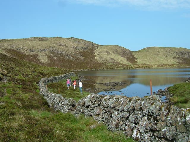
'S Airde Beinn — the Highest Hill — is a striking 295m volcanic crater hill north of Tobermory, with a deep crater lochan filling the summit cone. It is the most geologically dramatic small hill on Mull, the relic of an ancient eruption now ringed by a near-perfect circular ridge.
Quick facts
- Height
- 295m/ 968ft
- Prominence
- 153 m
- Grid ref
- NM 47094 53654
- Nearest city
- Oban· 45km
- Dogs
- Dogs on lead required near livestockDog-friendly guide ↗
Height and prominence cross-checked against the Database of British and Irish Hills (CC BY).
No GPX track yet
Walked this route? Share your track to help other walkers.
Standard route
heather and bog 65% · grass slopes 25% · rocky summit 10%
Park at the small lay-by on the B8073 just south of Loch a' Chumhainn and follow a faint path east up the heathery flank to the crater rim, then walk the circuit around the lochan. The full round is about 2 hours.
Terrain
Boggy heather on the approach, then a firm grassy crater rim with rocky sections where the volcanic neck breaks through. The rim path is sometimes wet on the eastern arc.
In winter
Low enough to be all but free of snow, even in hard winters. The crater rim can be slippery and exposed in a strong wind — keep below the crest if needed.
Best time of year
Getting there
- Glasgow5h 13m
- Edinburgh8h 47m
Ferry access
Oban → Craignure
- Crossing time45 min
- Summer sailingsUp to 8 sailings daily (Apr–Oct)
- Winter sailings4–5 sailings daily (Nov–Mar)
- Book ahead7 days
- Last ferry backCheck CalMac timetable — sailings run until ~21:00 in peak summer
Foot passengers can usually turn up without booking. Book vehicle spaces in advance. The Lochaline → Fishnish crossing (15 min) is shorter but serves east Mull only.
Book on CalMac ↗OS maps: OS Landranger 47, OS Explorer 374E
Mobile signal: Poor. A blackspot on every network on this remote Mull hill.
Current conditions
Daylight Today
- Sunrise
- 05:21
- Sunset
- 21:41
- Civil dawn
- 04:30
- Civil dusk
- 22:32
NOAA Solar Calculator · 30 July 2026
Around 'S Airde Beinn on the SCOT network
Getting there, basing yourself, and what to do off the hill.
Getting there: Morar station
Silver Sands, Knoydart approach, Loch Morar
43km from the hill
tripscot.co.uk
On TripSCOTBase yourself in Tobermory
Mull base — Ben More, Treshnish, ferry to Iona
4km from the hill
tripscot.co.uk
On TasteSCOTAfter the hill: Tobermory
Mull — colourful harbour-front distillery making both unpeated and peated (Ledaig) whisky
4km from the hill
tastescot.co.uk
'S Airde Beinn — common questions
- What difficulty is 'S Airde Beinn?
- On the OutdoorSCOT scale, 'S Airde Beinn comes in at 1/5 — easy. Terrain: Boggy heather on the approach, then a firm grassy crater rim with rocky sections where the volcanic neck breaks through.
- How prominent is 'S Airde Beinn?
- 'S Airde Beinn has 153m of topographic prominence — the height of its summit above the highest col connecting it to higher ground. Marilyns are defined by that measure: at least 150m of drop on all sides.
- When should I climb 'S Airde Beinn?
- The standard good-weather months for 'S Airde Beinn are March, April, May, June, July, August, September, October. Outside those months, expect winter conditions on the high ground — full mountain kit, navigation skills, and a check of the SAIS avalanche forecast for the relevant region.
- Can I bring my dog up 'S Airde Beinn?
- On a lead only — the route crosses ground with livestock or nesting-bird interest.
- What's mobile reception like on 'S Airde Beinn?
- Poor. A blackspot on every network on this remote Mull hill.
- How do I get the ferry to 'S Airde Beinn?
- Oban → Craignure. Up to 8 sailings daily (Apr–Oct) in summer; 4–5 sailings daily (Nov–Mar) in winter. Book at least 7 days ahead. Foot passengers can usually turn up without booking. Book vehicle spaces in advance. The Lochaline → Fishnish crossing (15 min) is shorter but serves east Mull only.
- Is 'S Airde Beinn safe in winter?
- Low enough to be all but free of snow, even in hard winters. The crater rim can be slippery and exposed in a strong wind — keep below the crest if needed.
Get the OutdoorSCOT weekly
One email a week — new route, hill and bothy guides, seasonal conditions and the odd hard-won lesson. No spam, unsubscribe in one click.