Marilyn · Argyll & Bute
Beinn na Drise
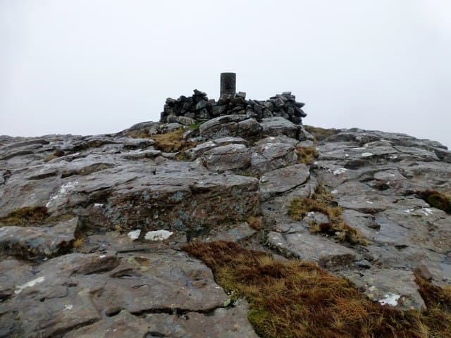
Beinn na Drise — the Hill of the Brambles — is a 424m top set above Loch Frisa on the north arm of Mull. The hill is unmistakable from the Tobermory road, a shapely cone of basalt steps with a small pointed summit.
Quick facts
- Height
- 424m/ 1391ft
- Prominence
- 347 m
- Grid ref
- NM 47518 42710
- Nearest city
- Oban· 40km
- Dogs
- Dogs on lead required near livestockDog-friendly guide ↗
Height and prominence cross-checked against the Database of British and Irish Hills (CC BY).
No GPX track yet
Walked this route? Share your track to help other walkers.
Standard route
heather and bog 65% · grass slopes 25% · rocky summit 10%
Start from the Forestry road end above Aros and follow the gravel track south, cutting up onto the open hillside once the trees are passed. The summit cone gives a short, steeper finish on grass and rock. Round trip is around 3.5 hours.
Terrain
Forestry tracks for the walk-in, then open heather and bracken. The summit cone is firm underfoot, with small rock outcrops to weave between near the top.
In winter
Sheltered by the Glengorm peninsula to the north, this hill often holds settled conditions when the south of Mull is in cloud. Snow is uncommon below the summit cone.
Best time of year
Getting there
- Glasgow5h 5m
- Edinburgh8h 41m
Ferry access
Oban → Craignure
- Crossing time45 min
- Summer sailingsUp to 8 sailings daily (Apr–Oct)
- Winter sailings4–5 sailings daily (Nov–Mar)
- Book ahead7 days
- Last ferry backCheck CalMac timetable — sailings run until ~21:00 in peak summer
Foot passengers can usually turn up without booking. Book vehicle spaces in advance. The Lochaline → Fishnish crossing (15 min) is shorter but serves east Mull only.
Book on CalMac ↗OS maps: OS Landranger 47, OS Landranger 48, OS Explorer 374E, OS Explorer 375W
Mobile signal: Poor. Every network fails on this isolated Mull hill.
Current conditions
Daylight Today
- Sunrise
- 05:22
- Sunset
- 21:40
- Civil dawn
- 04:31
- Civil dusk
- 22:31
NOAA Solar Calculator · 30 July 2026
Around Beinn na Drise on the SCOT network
Getting there, basing yourself, and what to do off the hill.
Getting there: Oban station
Argyll ferry hub; Mull, Lismore, Coll, Tiree, Barra connections
40km from the hill
tripscot.co.uk
On TripSCOTBase yourself in Tobermory
Mull base — Ben More, Treshnish, ferry to Iona
13km from the hill
tripscot.co.uk
On TasteSCOTAfter the hill: Tobermory
Mull — colourful harbour-front distillery making both unpeated and peated (Ledaig) whisky
13km from the hill
tastescot.co.uk
Beinn na Drise — common questions
- What difficulty is Beinn na Drise?
- On the OutdoorSCOT scale, Beinn na Drise comes in at 1/5 — easy. Ground conditions: Forestry tracks for the walk-in, then open heather and bracken.
- How much drop does Beinn na Drise have?
- The drop is 347m: measured from the summit of Beinn na Drise down to the saddle joining it to higher terrain. Passing the 150m-drop threshold on all sides is exactly what makes it a Marilyn.
- What's the best month to climb Beinn na Drise?
- Aim for March, April, May, June, July, August, September, October on Beinn na Drise. In the remaining months treat it as a winter hill — full kit, solid navigation, and a look at the relevant SAIS avalanche forecast before you go.
- Can dogs go up Beinn na Drise?
- Dogs are fine on a lead. The route passes livestock or ground-nesting bird habitat, so keep them close throughout.
- Will I get phone signal on Beinn na Drise?
- Poor. Every network fails on this isolated Mull hill.
- How do I get the ferry to Beinn na Drise?
- Oban → Craignure. Up to 8 sailings daily (Apr–Oct) in summer; 4–5 sailings daily (Nov–Mar) in winter. Book at least 7 days ahead. Foot passengers can usually turn up without booking. Book vehicle spaces in advance. The Lochaline → Fishnish crossing (15 min) is shorter but serves east Mull only.
- Is Beinn na Drise safe in winter?
- Sheltered by the Glengorm peninsula to the north, this hill often holds settled conditions when the south of Mull is in cloud. Snow is uncommon below the summit cone.
Get the OutdoorSCOT weekly
One email a week — new route, hill and bothy guides, seasonal conditions and the odd hard-won lesson. No spam, unsubscribe in one click.