Marilyn · Argyll & Bute
Beinn a' Ghraig
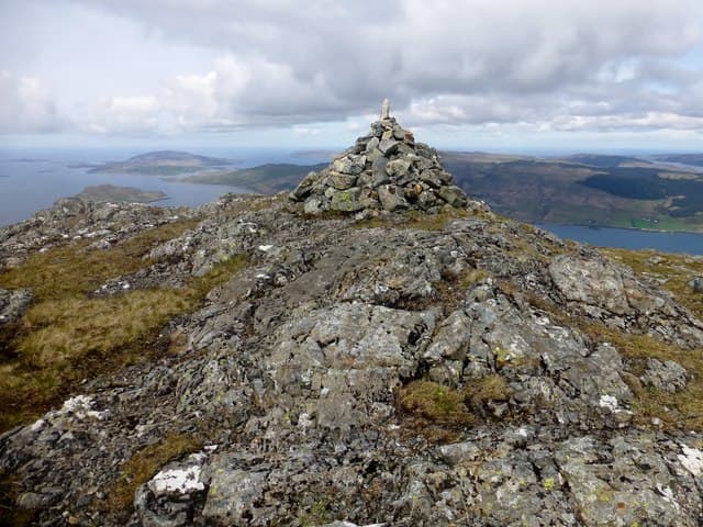
Beinn a' Ghraig stands 591m above the head of Loch na Keal on the north side of Mull, looking directly across to Ben More. Despite its proximity to the island's only Munro it sees very few boots, and the summit terraces of basalt offer a quiet, panoramic stage for the whole Mull skyline.
Quick facts
- Height
- 591m/ 1939ft
- Prominence
- 186 m
- Grid ref
- NM 54169 37263
- Nearest city
- Oban· 32km
- Dogs
- Dogs on lead required near livestockDog-friendly guide ↗
Height and prominence cross-checked against the Database of British and Irish Hills (CC BY).
No GPX track yet
Walked this route? Share your track to help other walkers.
Standard route
heather and bog 65% · grass slopes 25% · rocky summit 10%
Start from the verge near Knock on the B8035 below Loch Ba and head north up the slopes onto the broad shoulder. The line is pathless but the gradient is steady, threading between basalt step crags. Reckon on 3 to 4 hours return for the 591m summit.
Terrain
Stepped basalt terraces interleaved with damp heather and grass benches. Route-finding involves picking weaknesses between the small crags, easy in good weather but awkward in mist.
In winter
The Mull basalt holds water rather than snow, so the main winter problem is greasy rock on the terraces. A clear cold day with frozen turf is the best time to attempt the upper slopes.
Best time of year
Getting there
- Glasgow5h 46m
- Edinburgh7h 22m
Ferry access
Oban → Craignure
- Crossing time45 min
- Summer sailingsUp to 8 sailings daily (Apr–Oct)
- Winter sailings4–5 sailings daily (Nov–Mar)
- Book ahead7 days
- Last ferry backCheck CalMac timetable — sailings run until ~21:00 in peak summer
Foot passengers can usually turn up without booking. Book vehicle spaces in advance. The Lochaline → Fishnish crossing (15 min) is shorter but serves east Mull only.
Book on CalMac ↗OS maps: OS Landranger 47, OS Landranger 48, OS Explorer 374E, OS Explorer 375W
Mobile signal: Poor. No reliable signal; Mull's remote interior gives very limited coverage.
Current conditions
Daylight Today
- Sunrise
- 05:21
- Sunset
- 21:40
- Civil dawn
- 04:31
- Civil dusk
- 22:30
NOAA Solar Calculator · 30 July 2026
Around Beinn a' Ghraig on the SCOT network
Getting there, basing yourself, and what to do off the hill.
Getting there: Oban station
Argyll ferry hub; Mull, Lismore, Coll, Tiree, Barra connections
32km from the hill
tripscot.co.uk
On TripSCOTBase yourself in Tobermory
Mull base — Ben More, Treshnish, ferry to Iona
18km from the hill
tripscot.co.uk
On TasteSCOTAfter the hill: Tobermory
Mull — colourful harbour-front distillery making both unpeated and peated (Ledaig) whisky
18km from the hill
tastescot.co.uk
Beinn a' Ghraig — common questions
- Is Beinn a' Ghraig a hard climb?
- Beinn a' Ghraig is rated 2/5 (moderate) on the OutdoorSCOT scale. Ground conditions: Stepped basalt terraces interleaved with damp heather and grass benches.
- How much drop does Beinn a' Ghraig have?
- The drop is 186m: measured from the summit of Beinn a' Ghraig down to the saddle joining it to higher terrain. Passing the 150m-drop threshold on all sides is exactly what makes it a Marilyn.
- What's the best month to climb Beinn a' Ghraig?
- Aim for March, April, May, June, July, August, September, October on Beinn a' Ghraig. In the remaining months treat it as a winter hill — full kit, solid navigation, and a look at the relevant SAIS avalanche forecast before you go.
- Can dogs go up Beinn a' Ghraig?
- Dogs are fine on a lead. The route passes livestock or ground-nesting bird habitat, so keep them close throughout.
- Will I get phone signal on Beinn a' Ghraig?
- Poor. No reliable signal; Mull's remote interior gives very limited coverage.
- How do I get the ferry to Beinn a' Ghraig?
- Oban → Craignure. Up to 8 sailings daily (Apr–Oct) in summer; 4–5 sailings daily (Nov–Mar) in winter. Book at least 7 days ahead. Foot passengers can usually turn up without booking. Book vehicle spaces in advance. The Lochaline → Fishnish crossing (15 min) is shorter but serves east Mull only.
- Is Beinn a' Ghraig safe in winter?
- The Mull basalt holds water rather than snow, so the main winter problem is greasy rock on the terraces. A clear cold day with frozen turf is the best time to attempt the upper slopes.
Get the OutdoorSCOT weekly
One email a week — new route, hill and bothy guides, seasonal conditions and the odd hard-won lesson. No spam, unsubscribe in one click.