Sub-Marilyn · Argyll & Bute
Cruach Torr an Lochain
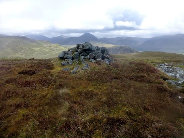
Cruach Torr an Lochain — the Stack of the Lochan Mound — is a 347m hill north of Loch Ba on Mull, hidden between the Salen road and the foot of Beinn Talaidh. Its name comes from the small lochan tucked just below the summit, a quiet pool that catches the reflection of the Ben More group.
Gaelic: “stack, the, small loch” · Pronunciation: kroo-ach torr an loch-een
Quick facts
- Height
- 347.7m/ 1141ft
- Prominence
- 149 m
- Grid ref
- NM 56413 40269
- Nearest city
- Oban· 31km
- Dogs
- Dogs on lead required near livestockDog-friendly guide ↗
Sub-Marilyn: 149m of drop — misses the 150m Marilyn cut by 1m. We keep it on the list as a near-miss.
Height and prominence cross-checked against the Database of British and Irish Hills (CC BY).
No GPX track yet
Walked this route? Share your track to help other walkers.
Standard route
heather and bog 65% · lochside bog 20% · rocky summit 15%
Park near Knock on the B8035 and head north-east across the road end to find a fishermen's path along the lochan shore, then climb the short rocky cone to the top. Round trip is under 3 hours.
Terrain
Boggy heather close to the lochan gives way to short basalt benches on the summit cone. The line is short and the rough ground does not last long.
In winter
A useful sheltered winter outing — the surrounding hills break the prevailing wind. The lochan margin can be slippery when frozen and refrozen.
Best time of year
Getting there
- Glasgow5h 43m
- Edinburgh7h 18m
Ferry access
Oban → Craignure
- Crossing time45 min
- Summer sailingsUp to 8 sailings daily (Apr–Oct)
- Winter sailings4–5 sailings daily (Nov–Mar)
- Book ahead7 days
- Last ferry backCheck CalMac timetable — sailings run until ~21:00 in peak summer
Foot passengers can usually turn up without booking. Book vehicle spaces in advance. The Lochaline → Fishnish crossing (15 min) is shorter but serves east Mull only.
Book on CalMac ↗OS maps: OS Landranger 47, OS Landranger 48, OS Explorer 374E, OS Explorer 375E, OS Explorer 375W
Mobile signal: Poor. No mobile signal on summit. Carry a paper map and compass.
Current conditions
Daylight Today
- Sunrise
- 05:21
- Sunset
- 21:40
- Civil dawn
- 04:30
- Civil dusk
- 22:30
NOAA Solar Calculator · 30 July 2026
Around Cruach Torr an Lochain on the SCOT network
Getting there, basing yourself, and what to do off the hill.
Getting there: Oban station
Argyll ferry hub; Mull, Lismore, Coll, Tiree, Barra connections
31km from the hill
tripscot.co.uk
On TripSCOTBase yourself in Tobermory
Mull base — Ben More, Treshnish, ferry to Iona
16km from the hill
tripscot.co.uk
On TasteSCOTAfter the hill: Tobermory
Mull — colourful harbour-front distillery making both unpeated and peated (Ledaig) whisky
16km from the hill
tastescot.co.uk
Cruach Torr an Lochain — common questions
- Is Cruach Torr an Lochain a hard climb?
- Cruach Torr an Lochain is rated 1/5 (easy) on the OutdoorSCOT scale. Underfoot: Boggy heather close to the lochan gives way to short basalt benches on the summit cone.
- What is Cruach Torr an Lochain's prominence?
- 149m of prominence. That's the vertical drop from the summit to the col that links Cruach Torr an Lochain to the next higher ground. That leaves it 1m short of the 150m drop a Marilyn needs — DoBIH classes it a sub-Marilyn, a near-miss rather than a full Marilyn.
- When is the best time to climb Cruach Torr an Lochain?
- March, April, May, June, July, August, September, October give the most reliable conditions on Cruach Torr an Lochain. Beyond that window the high ground turns wintry: carry full mountain kit, be confident navigating, and check the SAIS avalanche forecast for the area.
- Is Cruach Torr an Lochain dog-friendly?
- Yes, but dogs must be kept on a lead — there is livestock or ground-nesting bird interest on the route.
- Is there mobile signal on Cruach Torr an Lochain?
- Poor. No mobile signal on summit. Carry a paper map and compass.
- How do I get the ferry to Cruach Torr an Lochain?
- Oban → Craignure. Up to 8 sailings daily (Apr–Oct) in summer; 4–5 sailings daily (Nov–Mar) in winter. Book at least 7 days ahead. Foot passengers can usually turn up without booking. Book vehicle spaces in advance. The Lochaline → Fishnish crossing (15 min) is shorter but serves east Mull only.
- Is Cruach Torr an Lochain safe in winter?
- A useful sheltered winter outing — the surrounding hills break the prevailing wind. The lochan margin can be slippery when frozen and refrozen.
Get the OutdoorSCOT weekly
One email a week — new route, hill and bothy guides, seasonal conditions and the odd hard-won lesson. No spam, unsubscribe in one click.