Marilyn · Argyll & Bute
Beinn na Duatharach
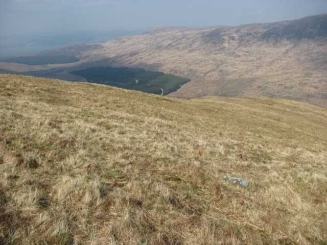
Beinn na Duatharach — the Hill of the Shadow — sits at 456m in the central uplands of Mull, set back from Loch Spelve and the head of Glen More. It is a hill that catches walkers by surprise: from the lay-bys on the A849 it looks unremarkable, but the summit view of Ben More across Loch Ba is one of the finest on the island.
Quick facts
- Height
- 456m/ 1496ft
- Prominence
- 305 m
- Grid ref
- NM 60471 36332
- Nearest city
- Oban· 26km
- Dogs
- Dogs on lead required near livestockDog-friendly guide ↗
Height and prominence cross-checked against the Database of British and Irish Hills (CC BY).
No GPX track yet
Walked this route? Share your track to help other walkers.
Standard route
heather and bog 65% · grass slopes 25% · rocky summit 10%
Park near the bend at the foot of Glen More on the A849 and head north up the broad grassy slopes, contouring left to avoid the worst of the bog. The ridge narrows pleasantly toward the cairn. Allow 3 hours return.
Terrain
Grass and short heather on the lower slopes, with extensive peat hags in the col between subsidiary tops. The summit ridge itself is dry and pleasant underfoot.
In winter
A reliable winter outing in the absence of significant snow cover, but the peat hags freeze and thaw unpredictably and can be deeply boot-soaking on a mild day after frost.
Best time of year
Getting there
- Glasgow5h 31m
- Edinburgh7h 6m
Ferry access
Oban → Craignure
- Crossing time45 min
- Summer sailingsUp to 8 sailings daily (Apr–Oct)
- Winter sailings4–5 sailings daily (Nov–Mar)
- Book ahead7 days
- Last ferry backCheck CalMac timetable — sailings run until ~21:00 in peak summer
Foot passengers can usually turn up without booking. Book vehicle spaces in advance. The Lochaline → Fishnish crossing (15 min) is shorter but serves east Mull only.
Book on CalMac ↗OS maps: OS Landranger 49, OS Explorer 375E
Mobile signal: Poor. No coverage on summit or approach; Ross of Mull is a known dead zone.
Current conditions
Daylight Today
- Sunrise
- 05:21
- Sunset
- 21:39
- Civil dawn
- 04:30
- Civil dusk
- 22:30
NOAA Solar Calculator · 30 July 2026
Around Beinn na Duatharach on the SCOT network
Getting there, basing yourself, and what to do off the hill.
Getting there: Oban station
Argyll ferry hub; Mull, Lismore, Coll, Tiree, Barra connections
26km from the hill
tripscot.co.uk
On TripSCOTBase yourself in Tobermory
Mull base — Ben More, Treshnish, ferry to Iona
21km from the hill
tripscot.co.uk
On TasteSCOTAfter the hill: Tobermory
Mull — colourful harbour-front distillery making both unpeated and peated (Ledaig) whisky
21km from the hill
tastescot.co.uk
Beinn na Duatharach — common questions
- How difficult is Beinn na Duatharach?
- Beinn na Duatharach carries a 1/5 (easy) grade on the OutdoorSCOT scale. Underfoot: Grass and short heather on the lower slopes, with extensive peat hags in the col between subsidiary tops.
- What is Beinn na Duatharach's prominence?
- 305m of prominence. That's the vertical drop from the summit to the col that links Beinn na Duatharach to the next higher ground. That drop is what qualifies it as a Marilyn — a hill with at least 150m of descent on every side.
- When is the best time to climb Beinn na Duatharach?
- March, April, May, June, July, August, September, October give the most reliable conditions on Beinn na Duatharach. Beyond that window the high ground turns wintry: carry full mountain kit, be confident navigating, and check the SAIS avalanche forecast for the area.
- Is Beinn na Duatharach dog-friendly?
- Yes, but dogs must be kept on a lead — there is livestock or ground-nesting bird interest on the route.
- Is there mobile signal on Beinn na Duatharach?
- Poor. No coverage on summit or approach; Ross of Mull is a known dead zone.
- How do I get the ferry to Beinn na Duatharach?
- Oban → Craignure. Up to 8 sailings daily (Apr–Oct) in summer; 4–5 sailings daily (Nov–Mar) in winter. Book at least 7 days ahead. Foot passengers can usually turn up without booking. Book vehicle spaces in advance. The Lochaline → Fishnish crossing (15 min) is shorter but serves east Mull only.
- Is Beinn na Duatharach safe in winter?
- A reliable winter outing in the absence of significant snow cover, but the peat hags freeze and thaw unpredictably and can be deeply boot-soaking on a mild day after frost.
Get the OutdoorSCOT weekly
One email a week — new route, hill and bothy guides, seasonal conditions and the odd hard-won lesson. No spam, unsubscribe in one click.