Marilyn · Perthshire
Beinn Uamha
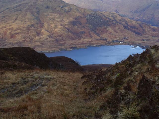
Beinn Uamha — the hill of the cave — rises to 596m above Glen Finglas, well inside the Trossachs at NN 386 069. It sits on the wild Mell ridge between Brig o' Turk and the head of Glen Finglas reservoir, looking south to the Loch Katrine watershed and west to Stob a' Choin. The "cave" of the name is a deep cleft on its eastern face.
Quick facts
- Height
- 596.8m/ 1958ft
- Prominence
- 265 m
- Grid ref
- NN 38647 06900
- Nearest city
- Stirling· 43km
- Dogs
- Dogs on lead required near livestockDog-friendly guide ↗
Height and prominence cross-checked against the Database of British and Irish Hills (CC BY).
No GPX track yet
Walked this route? Share your track to help other walkers.
Standard route
heather and bog 60% · rocky slopes 25% · grass slopes 15%
Start at the Glen Finglas car park at Brig o' Turk (NN 533 064) and follow the reservoir track north for around 5km, then strike west up a rough grassy spur onto the ridge. The summit lies at the south-western end of the ridge above the lonely waters of Loch nan Eun.
Terrain
Reservoir track then rough trackless moor — deep tussock and bog hags in the lower glen, more grassy and broken rock on the ridge crest. The cave-side cleft drops sharply on the east; keep well clear of the lip.
In winter
A wet, Atlantic-facing hill where rime ice builds on the east crags and verglas glazes the reservoir track. Snow lies in patches above 400m through January and February. Carry crampons if the freezing level drops below 500m.
Best time of year
Getting there
- Glasgow1h 19m
- Edinburgh4h 43m
OS maps: OS Landranger 56, OS Explorer 0039S, OS Explorer 364S
Mobile signal: Poor. Remote Argyll; faint on most networks.
Current conditions
Daylight Today
- Sunrise
- 05:17
- Sunset
- 21:33
- Civil dawn
- 04:27
- Civil dusk
- 22:23
NOAA Solar Calculator · 30 July 2026
Around Beinn Uamha on the SCOT network
Getting there, basing yourself, and what to do off the hill.
Beinn Uamha — common questions
- Is Beinn Uamha a hard climb?
- Beinn Uamha is rated 2/5 (moderate) on the OutdoorSCOT scale. Underfoot: Reservoir track then rough trackless moor — deep tussock and bog hags in the lower glen, more grassy and broken rock on the ridge crest.
- What is Beinn Uamha's prominence?
- 265m of prominence. That's the vertical drop from the summit to the col that links Beinn Uamha to the next higher ground. That drop is what qualifies it as a Marilyn — a hill with at least 150m of descent on every side.
- When is the best time to climb Beinn Uamha?
- March, April, May, June, July, August, September, October give the most reliable conditions on Beinn Uamha. Beyond that window the high ground turns wintry: carry full mountain kit, be confident navigating, and check the SAIS avalanche forecast for the area.
- Is Beinn Uamha dog-friendly?
- Yes, but dogs must be kept on a lead — there is livestock or ground-nesting bird interest on the route.
- Is there mobile signal on Beinn Uamha?
- Poor. Remote Argyll; faint on most networks.
- Is Beinn Uamha safe in winter?
- A wet, Atlantic-facing hill where rime ice builds on the east crags and verglas glazes the reservoir track. Snow lies in patches above 400m through January and February. Carry crampons if the freezing level drops below 500m.
Get the OutdoorSCOT weekly
One email a week — new route, hill and bothy guides, seasonal conditions and the odd hard-won lesson. No spam, unsubscribe in one click.