Marilyn · Argyll
Beinn Ghlas
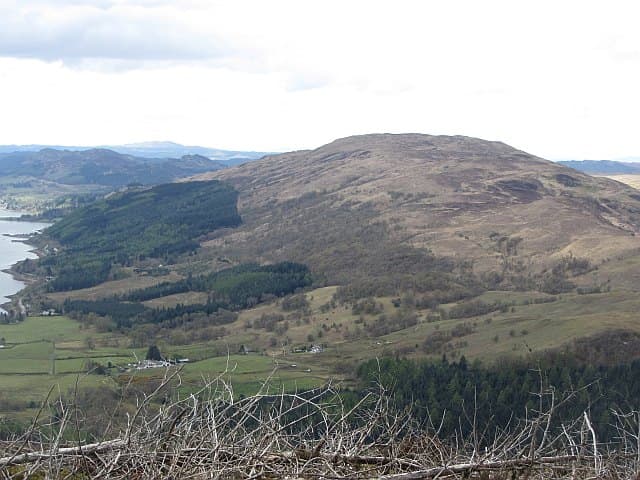
This lower Beinn Ghlas (Green-grey Hill) is the 420m high point of the long Kintyre ridge above Tarbert. From its crown you see Arran rising across Kilbrannan Sound and, on clear days, Antrim across the North Channel.
Gaelic: “mountain, grey-green” · Pronunciation: bine glass
Quick facts
- Height
- 420m/ 1378ft
- Grid ref
- NR 98930 99275
- Nearest city
- Oban· 33km
- Dogs
- Dogs on lead required near livestockDog-friendly guide ↗
No GPX track yet
Walked this route? Share your track to help other walkers.
Standard route
heather moorland 55% · grass slopes 30% · rocky summit 15%
A favourite line begins at Tarbert and follows farm tracks up onto the ridge, then a heather-and-grass crest north-east to the summit. Around 3 hours sees you up and back if conditions are dry.
Terrain
A pleasing mix of farm track, sheep-cropped grass and short heather. The ridge is broad enough to be safe in most conditions but narrow enough to keep direction obvious.
In winter
Mild Atlantic conditions are normal but rime ice forms on the trig pillar and ridge fenceposts in cold snaps. The exposed crest catches every gale that blows up the Kintyre peninsula.
Best time of year
Getting there
- Glasgow3h 39m
- Edinburgh5h 19m
OS maps: OS Landranger 55, OS Explorer 360S
Mobile signal: Moderate. Kintyre; reasonable coverage on eastern side.
Current conditions
Daylight Today
- Sunrise
- 04:35
- Sunset
- 22:13
- Civil dawn
- 03:32
- Civil dusk
- 23:16
NOAA Solar Calculator · 27 June 2026
Around Beinn Ghlas on the SCOT network
Getting there, basing yourself, and what to do off the hill.
Beinn Ghlas — common questions
- How hard is Beinn Ghlas?
- Beinn Ghlas is rated 1/5 (easy) on the OutdoorSCOT scale. Terrain: A pleasing mix of farm track, sheep-cropped grass and short heather.
- When is the best time to climb Beinn Ghlas?
- The standard good-weather months for Beinn Ghlas are March, April, May, June, July, August, September, October. Outside those months, expect winter conditions on the high ground — full mountain kit, navigation skills, and a check of the SAIS avalanche forecast for the relevant region.
- Can I bring my dog up Beinn Ghlas?
- Yes, but dogs must be kept on a lead — there is livestock or ground-nesting bird interest on the route.
- Is there mobile signal on Beinn Ghlas?
- Moderate. Kintyre; reasonable coverage on eastern side.
- Is Beinn Ghlas safe in winter?
- Mild Atlantic conditions are normal but rime ice forms on the trig pillar and ridge fenceposts in cold snaps. The exposed crest catches every gale that blows up the Kintyre peninsula.
Get the OutdoorSCOT weekly
One email a week — new route, hill and bothy guides, seasonal conditions and the odd hard-won lesson. No spam, unsubscribe in one click.