Marilyn · Argyll
Dun Leacainn
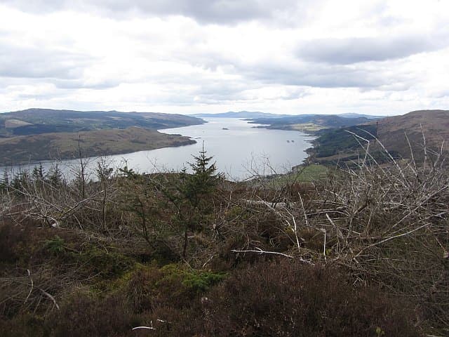
Dun Leacainn — the Fort of the Flat Slope — is a 360m hill rising directly above Furnace on Loch Fyne. The rocky knot at its summit gives a sudden view down the loch toward Inveraray.
Quick facts
- Height
- 360m/ 1181ft
- Prominence
- 272 m
- Grid ref
- NN 03359 01614
- Nearest city
- Oban· 33km
- Dogs
- Dogs on lead required near livestockDog-friendly guide ↗
Height and prominence cross-checked against the Database of British and Irish Hills (CC BY).
No GPX track yet
Walked this route? Share your track to help other walkers.
Standard route
heather moorland 60% · grass slopes 25% · rocky summit 15%
A direct ascent from the A83 at Furnace climbs steeply through hazel woodland before reaching open hillside above. The line is short but unrelentingly uphill; allow 2 to 3 hours return.
Terrain
Lower slopes are mixed woodland and steep grass. Above the trees the going is short heather, with bare slabs at the rocky summit knoll. The gradient is the chief obstacle.
In winter
A short hill but the steep grass slopes can be greasy in rain or treacherous when frozen. Avoid the direct approach in icy conditions.
Best time of year
Getting there
- Glasgow3h 30m
- Edinburgh5h 9m
OS maps: OS Landranger 55, OS Explorer 360S
Mobile signal: Very poor. No mobile signal on this remote hill; carry a PLB.
Current conditions
Daylight Today
- Sunrise
- 05:20
- Sunset
- 21:35
- Civil dawn
- 04:30
- Civil dusk
- 22:24
NOAA Solar Calculator · 30 July 2026
Around Dun Leacainn on the SCOT network
Getting there, basing yourself, and what to do off the hill.
Dun Leacainn — common questions
- How hard is Dun Leacainn?
- We grade Dun Leacainn at 1/5, which puts it in easy territory. Ground conditions: Lower slopes are mixed woodland and steep grass.
- How much drop does Dun Leacainn have?
- The drop is 272m: measured from the summit of Dun Leacainn down to the saddle joining it to higher terrain. Passing the 150m-drop threshold on all sides is exactly what makes it a Marilyn.
- What's the best month to climb Dun Leacainn?
- Aim for March, April, May, June, July, August, September, October on Dun Leacainn. In the remaining months treat it as a winter hill — full kit, solid navigation, and a look at the relevant SAIS avalanche forecast before you go.
- Can dogs go up Dun Leacainn?
- Dogs are fine on a lead. The route passes livestock or ground-nesting bird habitat, so keep them close throughout.
- Will I get phone signal on Dun Leacainn?
- Very poor. No mobile signal on this remote hill; carry a PLB.
- Is Dun Leacainn safe in winter?
- A short hill but the steep grass slopes can be greasy in rain or treacherous when frozen. Avoid the direct approach in icy conditions.
Get the OutdoorSCOT weekly
One email a week — new route, hill and bothy guides, seasonal conditions and the odd hard-won lesson. No spam, unsubscribe in one click.